Welcome to Sentosa, a Tropical island in the Singapore Strait, part of the majestic Pacific Ocean. This guide offers a comprehensive overview of what makes Sentosa unique – from its geography and climate to its population, infrastructure, and beyond. Dive into the details:
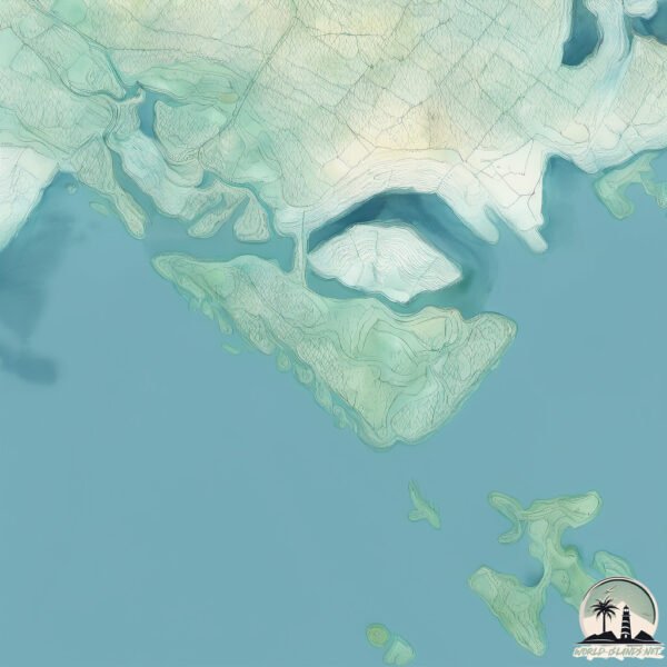
Geography and size of Sentosa
Size: 6.02 km²
Coastline: 20.2 km
Ocean: Pacific Ocean
Sea: Singapore Strait
Continent: Asia
Sentosa is a Small Island spanning 6 km² with a coastline of 20.2 km.
Archipel: Greater Sunda Islands – A group of large islands in Southeast Asia, including Borneo, Sumatra, Java, and Sulawesi, known for their rich biodiversity and cultural diversity.
Tectonic Plate: Molucca Sea – A small tectonic plate in the Molucca Sea in Indonesia, characterized by complex interactions with the surrounding Pacific, Eurasian, and Australian plates. Known for seismic activity and the formation of volcanic arcs.
The geographic heart of the island is pinpointed at these coordinates:
Latitude: 1.25166441 / Longitude: 103.83087699
Climate and weather of Sentosa
Climate Zone: Tropical
Climate Details: Tropical Rainforest Climate
Temperature: Hot
Climate Characteristics: This climate is typified by heavy rainfall throughout the year, high humidity, and consistently high temperatures, leading to lush rainforests and rich biodiversity. Seasonal temperature variations are minimal.
Topography and nature of Sentosa
Timezone: UTC+08:00
Timezone places: Australia/Perth
Max. Elevation: 20 m
Mean Elevation: 14 m
Vegetation: Agricultural Mosaic
Tree Coverage: 70%
The mean elevation is 14 m. The highest elevation on the island reaches approximately 20 meters above sea level. The island is characterized by Plains: Flat, low-lying lands characterized by a maximum elevation of up to 200 meters. On islands, plains are typically coastal lowlands or central flat areas.
Dominating Vegetation: Agricultural Mosaic
A mix of cropland and natural vegetation, often seen in rural landscapes where agricultural fields are interspersed with patches of natural habitats. Sentosa has a tree cover of 70 %.
Vegetation: 10 vegetation zones – Very Highly Diverse Island
Islands in this range are ecological powerhouses, showcasing a wide array of vegetation zones. Each zone, from lush rainforests to arid scrublands, coastal mangroves to mountainous regions, contributes to a complex and interdependent ecosystem. These islands are often hotspots of biodiversity, supporting numerous species and intricate ecological processes.
Infrastructure and Travelling to Sentosa
Does the island have a public airport? no.
There is no public and scheduled airport on Sentosa. The nearest airport is Seletar Airport, located 17 km away.
Does the island have a major port? no.
There are no major ports on Sentosa. The closest major port is KEPPEL – (EAST SINGAPORE), approximately 3 km away.
The mean population of Sentosa is 5013 per km². Sentosa is Densely Populated. The island belongs to Malaysia.
Continuing your journey, Singapore is the next notable island, situated merely km away.
12 BEST Things To Do In Sentosa Island Singapore
12 BEST Things To Do In Sentosa Island Singapore - Singapore Travel Guide Sentosa Island is a paradise in Singapore.12 BEST Things To Do In Sentosa Island Singapore
12 BEST Things To Do In Sentosa Island Singapore - Singapore Travel ...
12 BEST Things To Do In Sentosa Island Singapore - Singapore Travel Guide Sentosa Island is a paradise in Singapore.
Sentosa Island Singapore - An Informative City Guide in 2024
here's my Sentosa Island Singapore - An Informative City Guide in 2024 ...
here's my Sentosa Island Singapore - An Informative City Guide in 2024 Contact us via email:
ytmediabrands@gmail.com ...
Spent a day at Sentosa island #singapore #sentosasingapore #dailyshorts #viralshort #touristspot
Sentosa Singapore: Top 28 Things to Do and AVOID!!
Wanna have FUN in Sentosa without going BROKE? Watch this video! Get ...
Wanna have FUN in Sentosa without going BROKE? Watch this video! Get the ULTIMATE bookmarks for your SG trip: ...
Best Beaches of Singapore | Sentosa Island
When travelling to Singapore I thought I was going to be exploring the ...
When travelling to Singapore I thought I was going to be exploring the city every day but surprisingly enough they have some ...
How To Sped a Day In Sentosa Island 🏝️🇸🇬 #singapore #singaporevlog #travel #wanderingminds
A day on Sentosa island #singapore #dailyshorts #travel #indianinsingapore
Don't miss visiting Sentosa Island when in Singapore ! #sentosa #mustvisitplaces
24 Hours in Singapore Sentosa Island! #singapore #singaporetravel
How we spent 24 hours in Singapore Sentosa Island We checked in to The ...
How we spent 24 hours in Singapore Sentosa Island We checked in to The Outpost Hotel located inside Sentosa then ...
Where to Stay in Sentosa Island 🇸🇬 | Top 8 Luxury Hotels & Resorts
Best Hotels in Sentosa Island, Singapore ➡️ 1. Village Hotel Sentosa ...
Best Hotels in Sentosa Island, Singapore ➡️ 1. Village Hotel Sentosa Booking.com ...
Top 5 Luxury Resorts on Sentosa Island, Singapore
In this video discover the top 5 luxury resorts on Sentosa Island in ...
In this video discover the top 5 luxury resorts on Sentosa Island in Singapore. From beachside luxury, to tranquil pool escapes, ...
10 Things To Do At Sentosa! 🏝️
This is your Ultimate Family Travel Guide to Sentosa! Looking for an ...
This is your Ultimate Family Travel Guide to Sentosa! Looking for an unforgettable family day out? Here are 10 things you can do ...
‼️Don’t miss this budget hack for Singapore 🇸🇬 #singapore #travel
DO NOT buy the $4 Sentosa express ticket in Singapore ✓ Instead do ...
DO NOT buy the $4 Sentosa express ticket in Singapore ✓ Instead do this: Take the Sentosa Boardwalk from Vivocity Mall to ...
10 Best Things To Do in Sentosa, Singapore
Viator, a leading online platform and a subsidiary of TripAdvisor, ...
Viator, a leading online platform and a subsidiary of TripAdvisor, specializes in booking tours, activities, and travel experiences ...
Sentosa Island - I day itinerary from Singapore 🇸🇬 #sentosa #sentosasingapore #sentosaisland
Day trip around Sentosa Island, Singapore | Getaway
BEST 3 Days Sentosa Itinerary - By a Local Singaporean
Here's 3 days step-by-step itinerary for BEST experience in Sentosa ...
Here's 3 days step-by-step itinerary for BEST experience in Sentosa Singapore! Get a discount for eSims from Holafly: ...
Sentosa: Singapore’s Most Luxurious ‘Neighbourhood'? | Singapore Hour
Sentosa is a quick getaway destination for most, but for an exclusive ...
Sentosa is a quick getaway destination for most, but for an exclusive few, it's home. With boats docked at your doorstep and ...
No one told you this about SENTOSA Island in Singapore 🏖️🦚
Best things to do in sentosa island Singapore beyond resorts world and ...
Best things to do in sentosa island Singapore beyond resorts world and universal studios #singapore #sentosa #traveltips.
Best 9 Things to DO in Sentosa Island Singapore 1.0 | Singapore Travel Guide 2024
Best 9 Things To Do at Sentosa Island 1.0 Singapore Travel Guide. ...
Best 9 Things To Do at Sentosa Island 1.0 Singapore Travel Guide. Looking for the ultimate Sentosa Island experience? Look no ...
🏝️ Sentosa Island Singapore 2026 Tour | Siloso Beach To VivoCity CNY Market🧧🏞️🛍️
Sentosa Island Singapore 2026 Tour | Siloso Beach To VivoCity CNY ...
Sentosa Island Singapore 2026 Tour | Siloso Beach To VivoCity CNY Market Sentosa Island ushers in Chinese New Year 2026 ...
20 Best Things to Do in Sentosa Island Singapore
20 BEST Things to Do in Sentosa Island Singapore - Singapore Travel ...
20 BEST Things to Do in Sentosa Island Singapore - Singapore Travel Guide Are you looking for something fun to do in Sentosa, ...
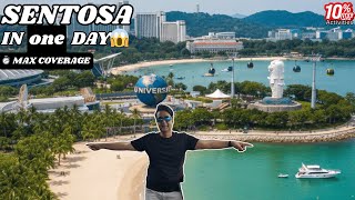
Sentosa Island in One Day | Max Coverage Itinerary + 10% OFF Activities
Sentosa Singapore in 1 Day: The Smartest Way to Explore! Planning to ...
Sentosa Singapore in 1 Day: The Smartest Way to Explore! Planning to visit Sentosa but only have one day? Don't worry—we've ...
🏝️Ultimate guide to Sentosa Island Singapore 🇸🇬 #singapore #sentosa
Ultimate Guide to Sentosa Island Singapore - Spend atleast 2 days - ...
Ultimate Guide to Sentosa Island Singapore - Spend atleast 2 days - Day 1️⃣ Universal Studios, Wings of time - Day 2️⃣ ...
Malaysia is classified as Developing region: Regions characterized by lower income levels, with economies in the process of industrialization and modernization. The level of income is Upper middle income.
News – Latest Updates and Headlines from Sentosa
Stay informed with the most recent news and important headlines from Sentosa. Here’s a roundup of the latest developments.
Loading...
Please note: The data used here has been primarily extracted from satellite readings. Deviations from exact values may occur, particularly regarding the height of elevations and population density. Land area and coastline measurements refer to average values at mean high tide.