Welcome to Shikotan, a Continental island in the Sea of Okhotsk, part of the majestic Pacific Ocean. This guide offers a comprehensive overview of what makes Shikotan unique – from its geography and climate to its population, infrastructure, and beyond. Dive into the details:
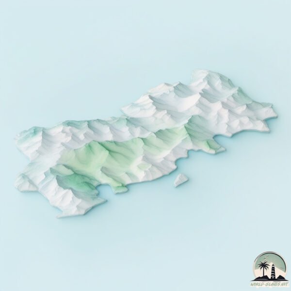
Geography and size of Shikotan
Size: 244.2 km²
Coastline: 194.3 km
Ocean: Pacific Ocean
Sea: Sea of Okhotsk
Continent: Asia
Shikotan is a Large Island spanning 244 km² with a coastline of 194 km.
Archipel: Kuril Islands – A volcanic archipelago stretching from Japan to Russia, known for their rugged landscapes and abundant marine life.
Tectonic Plate: North America – Covers North America and parts of the Atlantic and Arctic Oceans, characterized by diverse geological features and varying levels of seismic activity.
The geographic heart of the island is pinpointed at these coordinates:
Latitude: 43.80136863 / Longitude: 146.7390639
Climate and weather of Shikotan
Climate Zone: Continental
Climate Details: Warm-Summer Humid Continental Climate
Temperature: Warm Summer
Climate Characteristics: Features warm summers and cold winters with consistent precipitation, common in higher latitudes.
Topography and nature of Shikotan
Timezone: UTC+11:00
Timezone places: Asia/Vladivostok
Max. Elevation: 299 m
Mean Elevation: 95 m
Vegetation: Deciduous Broadleaf Forest
Tree Coverage: 47%
The mean elevation is 95 m. The highest elevation on the island reaches approximately 299 meters above sea level. The island is characterized by Hills: Gently sloping landforms with rounded tops, having a maximum elevation between 200 and 500 meters. Hills contribute to a varied landscape on islands.
Dominating Vegetation: Deciduous Broadleaf Forest
Composed of broadleaf trees that shed their leaves seasonally. These forests are commonly found in temperate zones and experience distinct seasonal changes. Shikotan has a tree cover of 47 %.
Vegetation: 10 vegetation zones – Very Highly Diverse Island
Islands in this range are ecological powerhouses, showcasing a wide array of vegetation zones. Each zone, from lush rainforests to arid scrublands, coastal mangroves to mountainous regions, contributes to a complex and interdependent ecosystem. These islands are often hotspots of biodiversity, supporting numerous species and intricate ecological processes.
Infrastructure and Travelling to Shikotan
Does the island have a public airport? no.
There is no public and scheduled airport on Shikotan. The nearest airport is Nakashibetsu Airport, located 182 km away.
Does the island have a major port? yes.
Shikotan is home to a major port. The following ports are situated on the island: SHAKOTAN.
The mean population of Shikotan is 5 per km². Shikotan is Gently Populated. The island belongs to Russia.
Continuing your journey, Taraku-jima is the next notable island, situated merely km away.
Sakhalin&Kuril Island: The Most Amazing Place You've Never Heard(1)
Sakhalin and the Kuril Islands: The Historical Disputes between Japan & Russia Two East Asian powerhouses, Japan and Russia ...Sakhalin&Kuril Island: The Most Amazing Place You've Never Heard(1)
Sakhalin and the Kuril Islands: The Historical Disputes between Japan ...
Sakhalin and the Kuril Islands: The Historical Disputes between Japan & Russia Two East Asian powerhouses, Japan and Russia ...
Shikotan Island
A small video about the trip to Shikotan island in autumn 2019. Filmed ...
A small video about the trip to Shikotan island in autumn 2019. Filmed with mavic 2 pro Music: Alx Beats - Everything would be ...
The islands of Kunashir and Shikotan, we go to the island of Iturup. Russia
The Kurils
This video is about the Kuril Island chain, some of my favorite ...
This video is about the Kuril Island chain, some of my favorite islands. This video tries to be complete in information but ...
Остров Шикотан / The Island Of Shikotan - 1972
Остров Шикотан Курильские о-ва Фотографии Юрий Садовников 1972 г. The ...
Остров Шикотан Курильские о-ва Фотографии Юрий Садовников 1972 г. The Island Of Shikotan Kuril Islands Photographs by ...
Sakhalin&Kuril Island: The Most Amazing Place You've Never Heard
Sakhalin and the Kuril Islands: The Historical Disputes between Japan ...
Sakhalin and the Kuril Islands: The Historical Disputes between Japan & Russia Two East Asian powerhouses, Japan and Russia ...
Одиночный поход по острову Шикотан / Solo trip to Shikotan Island
Закончился день, сижу у костра и думаю о родных, друзьях, о работе. ...
Закончился день, сижу у костра и думаю о родных, друзьях, о работе. Соскучился. Так много преодолел, чтобы попасть ...
Why Russia Won’t Give Up the Kuril Islands
Kuril Islands #japan #russia #war #disputedterritory #usa #worldwar2 ...
Kuril Islands #japan #russia #war #disputedterritory #usa #worldwar2 #geopolitics #mapanimation #worldconflict #globalconflict ...
Russia: Japanese heritage still visible across Shikotan *EXCLUSIVE*
W/S Japanese gravestones C/U Japanese gravestone C/U Japanese ...
W/S Japanese gravestones C/U Japanese gravestone C/U Japanese gravestone, text reads (Russian): "This is a grave, don't ...
Fog vibe from Shikotan island Russia 🇷🇺
Shikotan Island #shortvideo #top #top10 #travel #island #tiktok#paradise
You've definitely never been here! The most beautiful place on the ...
You've definitely never been here! The most beautiful place on the planet: Shikotan Island.
Металлолом/Остров Шикотан/Shikotan Island/色丹島/4k/16.11.2021 13:00
Металлолом/Остров Шикотан/Shikotan Island/色丹島/4k/16.11.2021 13:00.
Металлолом/Остров Шикотан/Shikotan Island/色丹島/4k/16.11.2021 13:00.
Shikotan. Kuril Islands. Solo Trip at May
Так я провел неделю на курильском острове Шикотан в мае 2024. Там есть ...
Так я провел неделю на курильском острове Шикотан в мае 2024. Там есть что посмотреть и дло сезона.
Dimitrovo Bay, Shikotan Island #seascapes
The painting depicts a seascape with a view of a small wave and rocks, ...
The painting depicts a seascape with a view of a small wave and rocks, painted with oil paint in a quiet bay, Shikotan Island, ...
Кафе в Малокурильске/Остров Шикотан/Shikotan Island/色丹島/4k/09.11.2021 09:30
Шикотан #ОстровШикотан #Малокурильск #Крабозаводск #ShikotanIsland ...
Шикотан #ОстровШикотан #Малокурильск #Крабозаводск #ShikotanIsland #KurileIslands #Theendoftheworld #シコタン島 ...
Разлом/Остров Шикотан/Shikotan Island/色丹島/4k/20.11.2021 16:00
Разлом/Остров Шикотан/Shikotan Island/色丹島/4k/20.11.2021 16:00.
Разлом/Остров Шикотан/Shikotan Island/色丹島/4k/20.11.2021 16:00.
Спорт Арена/Остров Шикотан/Shikotan Island/色丹島/4k/13.11.2021 10:00
Спортивный центр на Шикотане.
Спортивный центр на Шикотане.
Trip to Shikotan Island
2018.7.19~2018.7.23 ビザなし交流で色丹島に訪問してきました。 スマホで撮った動画をまとめただけの動画です。
2018.7.19~2018.7.23 ビザなし交流で色丹島に訪問してきました。 スマホで撮った動画をまとめただけの動画です。
б. Канатка/Остров Шикотан/Shikotan Island/色丹島/4k/07.11.2021 13:00
б. Канатка/Остров Шикотан/Shikotan Island/色丹島/4k/07.11.2021 13:00 ...
б. Канатка/Остров Шикотан/Shikotan Island/色丹島/4k/07.11.2021 13:00 #Шикотан #ОстровШикотан #Малокурильск ...
р. Отрада/Остров Шикотан/Shikotan Island/色丹島/4k/09.11.2021 09:40
Шикотан #ОстровШикотан #Малокурильск #Крабозаводск #ShikotanIsland ...
Шикотан #ОстровШикотан #Малокурильск #Крабозаводск #ShikotanIsland #KurileIslands #Theendoftheworld #シコタン島 ...
Russia is classified as Emerging region: BRIC: Brazil, Russia, India, and China – Economies noted for their rapid growth and increasing influence on global affairs. The level of income is Upper middle income.
News – Latest Updates and Headlines from Shikotan
Stay informed with the most recent news and important headlines from Shikotan. Here’s a roundup of the latest developments.
Loading...
Please note: The data used here has been primarily extracted from satellite readings. Deviations from exact values may occur, particularly regarding the height of elevations and population density. Land area and coastline measurements refer to average values at mean high tide.