Welcome to Shirley, a Tropical island in the Indian Ocean, part of the majestic Indian Ocean. This guide offers a comprehensive overview of what makes Shirley unique – from its geography and climate to its population, infrastructure, and beyond. Dive into the details:
Geography and size of Shirley
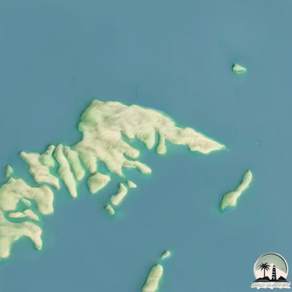
Size: 2.129 km²
Coastline: 10.2 km
Ocean: Indian Ocean
Sea: Indian Ocean
Continent: Oceania
Shirley is a Small Island spanning 2.1 km² with a coastline of 10.2 km.
Archipel: –
Tectonic Plate: Australia – A major tectonic plate covering Australia, New Zealand, and parts of the Indian and Pacific Oceans, known for its relative stability and occasional seismic activity.
The geographic heart of the island is pinpointed at these coordinates:
Latitude: -16.26891235 / Longitude: 123.4442778
Climate and weather of Shirley
Climate Zone: Tropical
Climate Details: Tropical Savanna, Wet
Temperature: Hot
Climate Characteristics: Defined by distinct wet and dry seasons with high temperatures year-round. Pronounced rainfall occurs during the wet season, while the dry season is marked by drought.
Topography and nature of Shirley
Timezone: UTC+08:00
Timezone places: Australia/Perth
Max. Elevation: 15 m
Mean Elevation: 15 m
Vegetation: Herbaceous Cover
Tree Coverage: 19%
The mean elevation is 15 m. The highest elevation on the island reaches approximately 15 meters above sea level. The island is characterized by Plains: Flat, low-lying lands characterized by a maximum elevation of up to 200 meters. On islands, plains are typically coastal lowlands or central flat areas.
Dominating Vegetation: Herbaceous Cover
Comprising mainly of grasses, herbs, and ferns, these areas are common in prairies, meadows, and savannas, and can vary widely in species composition. Shirley has a tree cover of 19 %.
Vegetation: 3 vegetation zones – Moderately Diverse Island
These islands start to show a broader range of ecological niches. With three vegetation zones, they may offer a mix of ecosystems like coastal areas, inland woods, and perhaps a distinct wetland or dry area. This diversity supports a wider range of flora and fauna, making these islands more ecologically complex than those with minimal diversity.
Infrastructure and Travelling to Shirley
Does the island have a public airport? no.
There is no public and scheduled airport on Shirley. The nearest airport is Broome International Airport, located 229 km away.
Does the island have a major port? no.
There are no major ports on Shirley. The closest major port is BROOME, approximately 231 km away.
The mean population of Shirley is per km². Shirley is . The island belongs to Australia.
Continuing your journey, Hidden is the next notable island, situated merely km away.
The Siege Of Shirley Island | Community
Shirley Island is attacked by the chairwalkers...I'm still haunted by this day. #Community #Lava #Chairs Watch Community Now: ...The Siege Of Shirley Island | Community
Shirley Island is attacked by the chairwalkers...I'm still haunted by ...
Shirley Island is attacked by the chairwalkers...I'm still haunted by this day. #Community #Lava #Chairs Watch Community Now: ...
Community | Welcome To Shirley Island! | Daily Laugh
This game of Hot Lava is getting intense! From Season 5 Episode 5, ...
This game of Hot Lava is getting intense! From Season 5 Episode 5, 'Geothermal Escapism', As a going-away present to Troy ...
Cheap Lunch: Shirley's Island Cuisine
✨Shirley Horn- The island🎷
Welcome to Jazz Odyssey ✨Embark on a musical journey with "Jazz ...
Welcome to Jazz Odyssey ✨Embark on a musical journey with "Jazz Odyssey," your ultimate destination for exploring the rich ...
Shirley is dol op nep 🙄 | Eating with my Ex: Going Dutch
Dat is niet zo lief om te zeggen hè, Damian... Lees alles over het ...
Dat is niet zo lief om te zeggen hè, Damian... Lees alles over het derde seizoen van 'Eating with my Ex: Going Dutch' op ...
Antarctica Vlog Ep. 4: Wildlife on Shirley Island
Come with me to Shirley Island, Antarctica as we observe the penguins ...
Come with me to Shirley Island, Antarctica as we observe the penguins and seals in their natural habitat.
Roy Shirley - Music Island
Public PRE JA.
Public PRE JA.
Adelie penguins at Shirley Island
Adelies are quite curious birds and will come up to investigate human ...
Adelies are quite curious birds and will come up to investigate human expeditioners when we pop over for a visit.
Robin Hood Island Shirley: Right Turn ( very easy )
Learn how to make a right turn at the Robin Hood Island in Shirley ...
Learn how to make a right turn at the Robin Hood Island in Shirley with this easy tutorial. For inquiry e-mail ...
Meet Frankie, The New Shirley | Community
The Save Greendale Committee discuss the frisbee incident in the study ...
The Save Greendale Committee discuss the frisbee incident in the study room. Dean Pelton interrupts the meeting to introduce a ...
Shirley Dies In D&D | Community
Shirley hands in her character sheet during a Dungeons and Dragons ...
Shirley hands in her character sheet during a Dungeons and Dragons game. #Shirley #DND #Community Watch Community ...
Shirley Island Penguin Colony: Antarctica
We arrived at Casey Station and received a warm welcome from the ...
We arrived at Casey Station and received a warm welcome from the winterer's and shown around station. One winterer Cliff took ...
KiteBoarding Shirley Island Jul 2011
Shirley Heights isn’t just one of the best views in Antigua 🇦🇬 #antiguaandbarbuda #thingstodo
Shirley Heights isn't just one of the best views in Antigua it's a ...
Shirley Heights isn't just one of the best views in Antigua it's a full experience that blends history, nature, and culture all in ...
COMMUNITY - #Storytime with Shirley/ Island Bazaar
We love our authorized Ohana dealers. We are proud to boast about our ...
We love our authorized Ohana dealers. We are proud to boast about our dealers who are movers and shakers in their own uke ...
Surely Shirley - Honeymoon Island (Official Music Video)
Surely Shirley's debut single 'Honeymoon Island' DOP Tas Wilson Edit ...
Surely Shirley's debut single 'Honeymoon Island' DOP Tas Wilson Edit Tas Wilson Grade Tas Wilson Directed Tas Wilson, Anisha ...
😯😅 Shirley (Ex On The Beach) haar afknappers bij mannen #shirley #exonthebeach #interview
JEFFERY EPSTEIN’S DARK SECRETS REVEALED
Shroom Safari to Waterfall at Funky Forest on Vancouver Island in Shirley, BC, Canada
Shirley Driving Test Center -Route-Lesson 01- How to take 5th Exit at Robin hood roundabout
Shirley Driving Test Center -Route-Lesson 01, This short video would ...
Shirley Driving Test Center -Route-Lesson 01, This short video would show you how to take 5th exit at Robin hood roundabout ...
The Horrifying Final Moments Of Shirley Durdin: EATEN ALIVE
The Following Story is known as the most brutal shark attacks in ...
The Following Story is known as the most brutal shark attacks in recorded history... This terrifying attack took place just off the ...
Curly Top (1935) Full Movie | Shirley Temple | Family Musical
Watch the full movie 'Curly Top' (1935), a delightful classic family ...
Watch the full movie 'Curly Top' (1935), a delightful classic family musical starring the beloved Shirley Temple. Directed by Irving ...
Celebrity Silhouette Pt.6 - Antigua, Scenic Island & Beach Tour, Shirley Heights, Nelson's Dockyard
Welcome to Antigua! We're off on a ship excursion to discover parts of ...
Welcome to Antigua! We're off on a ship excursion to discover parts of the island that we haven't seen before such as Shirley ...
The BEST VIEW of Antigua - Shirley Heights Sunday Nights!
The absolute best sunset views are at Shirley Heights in Antigua. ...
The absolute best sunset views are at Shirley Heights in Antigua. Every Sunday night there is a BBQ party with steel drums, rum ...
Top 10 Places On The Aeolian Islands - Travel Guide
I recently returned from sailing around the Aeolian Islands and I want ...
I recently returned from sailing around the Aeolian Islands and I want to share with you my favorite places. Located off of Sicily's ...
Australia is classified as Developed region: nonG7: Developed economies outside of the Group of Seven, characterized by high income and advanced economic structures. The level of income is High income: OECD.
News – Latest Updates and Headlines from Shirley
Stay informed with the most recent news and important headlines from Shirley. Here’s a roundup of the latest developments.
Loading...
Please note: The data used here has been primarily extracted from satellite readings. Deviations from exact values may occur, particularly regarding the height of elevations and population density. Land area and coastline measurements refer to average values at mean high tide.