Welcome to Siberut, a Tropical island in the Indian Ocean, part of the majestic Indian Ocean. This guide offers a comprehensive overview of what makes Siberut unique – from its geography and climate to its population, infrastructure, and beyond. Dive into the details:
Geography and size of Siberut
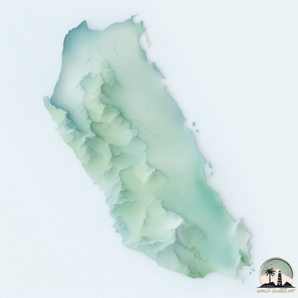
Size: 3848 km²
Coastline: 470 km
Ocean: Indian Ocean
Sea: Indian Ocean
Continent: Asia
Siberut is a Very Large Island spanning 3848 km² with a coastline of 470 km.
Archipel: Malay Archipelago – The world’s largest archipelago, located between mainland Southeast Asia and Australia, known for its immense biodiversity and cultural diversity.
Tectonic Plate: Sunda – Extends across Southeast Asia, encompassing parts of the Sunda Shelf, known for its interaction with the Australian Plate, contributing to volcanic activity in Indonesia.
The geographic heart of the island is pinpointed at these coordinates:
Latitude: -1.37433895 / Longitude: 98.92751675
Climate and weather of Siberut
Climate Zone: Tropical
Climate Details: Tropical Rainforest Climate
Temperature: Hot
Climate Characteristics: This climate is typified by heavy rainfall throughout the year, high humidity, and consistently high temperatures, leading to lush rainforests and rich biodiversity. Seasonal temperature variations are minimal.
Topography and nature of Siberut
Timezone: UTC+07:00
Timezone places: Asia/Jakarta
Max. Elevation: 315 m
Mean Elevation: 86 m
Vegetation: Evergreen Broadleaf Forest
Tree Coverage: 75%
The mean elevation is 86 m. The highest elevation on the island reaches approximately 315 meters above sea level. The island is characterized by Hills: Gently sloping landforms with rounded tops, having a maximum elevation between 200 and 500 meters. Hills contribute to a varied landscape on islands.
Dominating Vegetation: Evergreen Broadleaf Forest
Characterized by dense, lush canopies of broadleaf trees that retain their leaves year-round. These forests are typically found in tropical and subtropical regions and are known for their high biodiversity. Siberut has a tree cover of 75 %.
Vegetation: 12 vegetation zones – Exceptionally Diverse Island
Islands with more than ten vegetation zones are among the most ecologically rich and varied in the world. These islands are akin to miniature continents, boasting an incredible array of ecosystems. The sheer range of habitats, from high peaks to deep valleys, rainforests to deserts, creates a mosaic of life that is unparalleled. They are crucial for conservation and ecological studies.
Infrastructure and Travelling to Siberut
Does the island have a public airport? no.
There is no public and scheduled airport on Siberut. The nearest airport is Lasondre Airport, located 112 km away.
Does the island have a major port? no.
There are no major ports on Siberut. The closest major port is TELUK BAYUR, approximately 139 km away.
The mean population of Siberut is 14 per km². Siberut is Gently Populated. The island belongs to Indonesia.
The name of the island resonates across different cultures and languages. Here is how it is known around the world: Arabic: سيبروت; German: Siberut; Spanish: Siberut; French: Siberut; Portuguese: Siberut; Russian: Сиберут; Chinese: 西比路島
Continuing your journey, Pulau Masokut is the next notable island, situated merely km away.
Living With The Mentawai Tribe of Indonesia - 2,000 Year Old Jungle Tribe
Come travel with me deep into the Indonesian jungle to live with the Mentawai Tribe — one of the world's oldest, most isolated ...Living With The Mentawai Tribe of Indonesia - 2,000 Year Old Jungle Tribe
Come travel with me deep into the Indonesian jungle to live with the ...
Come travel with me deep into the Indonesian jungle to live with the Mentawai Tribe — one of the world's oldest, most isolated ...
LIVING 6 DAYS with MENTAWAI TRIBE in Siberut Island, Indonesia
In today's episode I dive deep into the Tribe life of the Mentawai ...
In today's episode I dive deep into the Tribe life of the Mentawai people on Siberut Island, located off the coast of Padang, West ...
Discover Indonesia's Hidden Paradise Siberut Island, Mentawai (Part 1)
Through this video, you will get introduced to the seven magical ...
Through this video, you will get introduced to the seven magical elements in Mentawai Archipelago, namely (1) surfing one of the ...
LIVING 5 DAYS with MENTAWAI TRIBE in Siberut Island, Indonesia
In today's episode I'm going to be diving deep into the tribe life of ...
In today's episode I'm going to be diving deep into the tribe life of the Mentawai people on Siberut island across from Padang ...
LIVING with a 2,000 Year Old Tribe in Sumatra - MENTAWAI, Indonesia 🇮🇩
MENTAWAI ISLANDS 4K ADVENTURE-CINEMATIC
Welcome to our YouTube channel, where we take you on an exhilarating ...
Welcome to our YouTube channel, where we take you on an exhilarating journey to the exotic Mentawai Islands. Here is all about ...
Uncovering An EPIC Hidden Gem: The Mentawai Islands, Indonesia
We had the most amazing time uncovering an EPIC hidden Gem. The ...
We had the most amazing time uncovering an EPIC hidden Gem. The Mentawai Islands in Indonesia are a beautiful remote ...
What Life Is Really Like on Siberut Island (Indonesia’s Forgotten Island)
We travel from Padang to Siberut Island, one of the most remote places ...
We travel from Padang to Siberut Island, one of the most remote places in Indonesia, to discover what daily life is like for the locals ...
Mentawai Siberut ısland shaman living deep inside of the jungle #mentawaiisland #exploreindonesia
The Mentawai people of Siberut Island, which is part of the Mentawai ...
The Mentawai people of Siberut Island, which is part of the Mentawai Archipelago off the west coast of Sumatra, are renowned for ...
SURVIVING 5 Days with the Mentawai Tribe on a REMOTE Island 🇮🇩
Change video quality to 2160p, sit back and enjoy this episode. If you ...
Change video quality to 2160p, sit back and enjoy this episode. If you want to come and say hi: Instagram: ...
The TRUTH About The MENTAWAI Tribe In Indonesia (Part 1)
In this four-part series, we're taking you deep into the jungle, to ...
In this four-part series, we're taking you deep into the jungle, to spend five days living with the Mentawai Tribe The Mentawai ...
Sumatra - Siberut 2022
The journey to western Sumatra and 6-days trip on Siberut island to ...
The journey to western Sumatra and 6-days trip on Siberut island to Mentawai tribe.
🏄♂️🌴 Dive into Paradise at Sabbit Mentawai Surf Camp! 🌊☀️
Prepare to be mesmerized by an idyllic island oasis surrounded by the ...
Prepare to be mesmerized by an idyllic island oasis surrounded by the kind of blue water that'll make you question if you're in ...
EP2 മെന്തവായി ദ്വീപിലെ കാട്ട് മനുഷ്യരെ തേടി ഞങ്ങളൊരുമിച്ച് കാട്ടിലേക്ക് Traveling To Mentawai Island
A Journey into the Mentawai Tribal Lands The decision to travel to ...
A Journey into the Mentawai Tribal Lands The decision to travel to Mentawai began with a story I once heard about an ancient ...
How To Get to the Mentawai Islands! | Full Guide
The Northern Mentawai Islands are a remote paradise. Oscar sits down ...
The Northern Mentawai Islands are a remote paradise. Oscar sits down with you to explain everything you need to know about ...
How to Visit the Mentawai Tribes in Indonesia 🇮🇩
Would you live with the Mentawai? 🏝️ I Was shocked that I was able to ...
Would you live with the Mentawai? 🏝️ I Was shocked that I was able to get passable service, in the most remote place I ...
The MOST BEAUTIFUL Islands In INDONESIA [Episode 26]
As always, before starting our activities, we arm ourselves with ...
As always, before starting our activities, we arm ourselves with Enervon Active to keep our bodies active and ...
Crossed From Bali To Mentawai To Live With A 2,000 Year Old Tribe
The moment we were waiting for after 3 months of traveling! 2 Girls, 1 ...
The moment we were waiting for after 3 months of traveling! 2 Girls, 1 Dog, 1 Motorbike. Crossing all the way from Bali to ...
Mengenal Pulau Siberut, Provinsi Sumatera Barat.
Pulau Siberut adalah sebuah Pulau terbesar di provinsi Sumatera Barat.
Pulau Siberut adalah sebuah Pulau terbesar di provinsi Sumatera Barat.
REMOTE AREAS : Exploring Remote Areas of Siberut (Part1)
Located in the Mentawai Islands, Indonesia, Siberut is the largest ...
Located in the Mentawai Islands, Indonesia, Siberut is the largest island in the archipelago. Despite its size, many areas remain ...
Living with Mentawai tribe 🫶🏻#mentawai #sumatra #siberut #indo #travelvlogs #indonesiatravel
Living with a tribe in Indonesia #shorts #mentawaiisland #travel
Living with a tribe can be an incredible and enriching experience. It ...
Living with a tribe can be an incredible and enriching experience. It offers the chance to immerse yourself in a culture and lifestyle ...
Indonesia: Returning to Siberut Island after 30 years
World Bank biodiversity specialist Tony Whitten returns to Siberut ...
World Bank biodiversity specialist Tony Whitten returns to Siberut more than 30 years after conducting wildlife research on the ...
travel adventure jungle treking Siberut mentawai island
travel adventure jungle treking Siberut mentawai island journey starts ...
travel adventure jungle treking Siberut mentawai island journey starts from the city of Padang with Mentawai fast boat we made a ...
Exploring Siberut Island, an island in Mentawai Islands Regency off the coast of Sumatra, Indonesia.
After finishing an exploration somewhere in Padang, Sumatra, ...
After finishing an exploration somewhere in Padang, Sumatra, Indonesia, we decided to take a 3-hour ferry trip from Padang to ...
Indonesia is classified as Emerging region: MIKT: Mexico, Indonesia, South Korea, and Turkey – Economies recognized for their development potential and emerging market status. The level of income is Lower middle income.
News – Latest Updates and Headlines from Siberut
Stay informed with the most recent news and important headlines from Siberut. Here’s a roundup of the latest developments.
Loading...
Social Media Posts about Siberut
Loading...
Please note: The data used here has been primarily extracted from satellite readings. Deviations from exact values may occur, particularly regarding the height of elevations and population density. Land area and coastline measurements refer to average values at mean high tide.


![The MOST BEAUTIFUL Islands In INDONESIA [Episode 26]](https://i.ytimg.com/vi/QYVUy8uiMVM/mqdefault.jpg)


