Sibuyan
Welcome to Sibuyan, a Tropical island in the Philippine Sea, part of the majestic Pacific Ocean. This guide offers a comprehensive overview of what makes Sibuyan unique – from its geography and climate to its population, infrastructure, and beyond. Dive into the details:
- Geography and Size: Explore the island’s size and location.
- Climate and Weather: Weather patterns and temperature.
- Topography and Nature: Uncover the natural wonders of the island.
- Infrastructure and Travelling: Insights on reaching, staying, and making the most of your visit.
- News and Headlines: Latest News.
Geography and size of Sibuyan
Size: 455.4 km²
Coastline: 104.5 km
Ocean: Pacific Ocean
Sea: Philippine Sea
Continent: Asia
Sibuyan is a Large Island spanning 455 km² with a coastline of 104 km.
Archipel: Malay Archipelago – The world’s largest archipelago, located between mainland Southeast Asia and Australia, known for its immense biodiversity and cultural diversity.
Tectonic Plate: Sunda – Extends across Southeast Asia, encompassing parts of the Sunda Shelf, known for its interaction with the Australian Plate, contributing to volcanic activity in Indonesia.
The geographic heart of the island is pinpointed at these coordinates:
Latitude: 12.40813581 / Longitude: 122.57620438
Climate and weather of Sibuyan
Climate Zone: Tropical
Climate Details: Tropical Rainforest Climate
Temperature: Hot
Climate Characteristics: This climate is typified by heavy rainfall throughout the year, high humidity, and consistently high temperatures, leading to lush rainforests and rich biodiversity. Seasonal temperature variations are minimal.
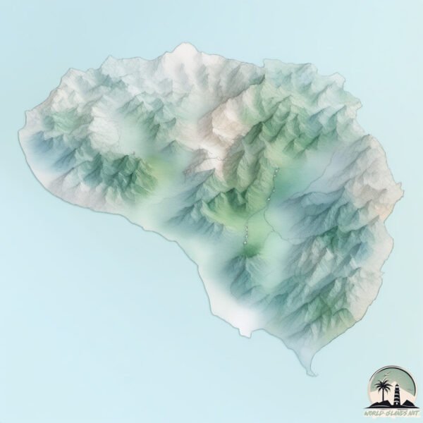
Topography and nature of Sibuyan
Timezone: UTC+08:00
Timezone places: Australia/Perth
Max. Elevation: 2050 m Sibuyan Island HP
Mean Elevation: 369 m
Vegetation: Evergreen Broadleaf Forest
Tree Coverage: 60%
The mean elevation is 369 m. Dominating the island’s landscape, the majestic “Sibuyan Island HP” rises as the highest peak, soaring to impressive heights. The island is characterized by Mountains: High, steeply elevated landforms. Characterized by both a high maximum elevation (over 500 meters) and a high mean elevation, creating rugged, mountainous terrains on islands.
Dominating Vegetation: Evergreen Broadleaf Forest
Characterized by dense, lush canopies of broadleaf trees that retain their leaves year-round. These forests are typically found in tropical and subtropical regions and are known for their high biodiversity. Sibuyan has a tree cover of 60 %.
Vegetation: 13 vegetation zones – Exceptionally Diverse Island
Islands with more than ten vegetation zones are among the most ecologically rich and varied in the world. These islands are akin to miniature continents, boasting an incredible array of ecosystems. The sheer range of habitats, from high peaks to deep valleys, rainforests to deserts, creates a mosaic of life that is unparalleled. They are crucial for conservation and ecological studies.
Infrastructure and Travelling to Sibuyan
Does the island have a public airport? no.
There is no public and scheduled airport on Sibuyan. The nearest airport is Tugdan Airport, located 40 km away.
Does the island have a major port? no.
There are no major ports on Sibuyan. The closest major port is PORT ROMBLON, approximately 23 km away.
The mean population of Sibuyan is 132 per km². Sibuyan is Moderately Inhabited. The island belongs to Philippines.
Continuing your journey, Romblon is the next notable island, situated merely km away.
Why Visiting Sibuyan was a BIG mistake


Philippines is classified as Emerging region: G20: Group of Twenty – Major economies comprising both developed and emerging countries, representing the world’s largest economies. The level of income is Lower middle income.
News – Latest Updates and Headlines from Sibuyan
Stay informed with the most recent news and important headlines from Sibuyan. Here’s a roundup of the latest developments.
Please note: The data used here has been primarily extracted from satellite readings. Deviations from exact values may occur, particularly regarding the height of elevations and population density. Land area and coastline measurements refer to average values at mean high tide.