Simushir
Welcome to Simushir, a Polar island in the Sea of Okhotsk, part of the majestic Pacific Ocean. This guide offers a comprehensive overview of what makes Simushir unique – from its geography and climate to its population, infrastructure, and beyond. Dive into the details:
- Geography and Size: Explore the island’s size and location.
- Climate and Weather: Weather patterns and temperature.
- Topography and Nature: Uncover the natural wonders of the island.
- Infrastructure and Travelling: Insights on reaching, staying, and making the most of your visit.
- News and Headlines: Latest News.
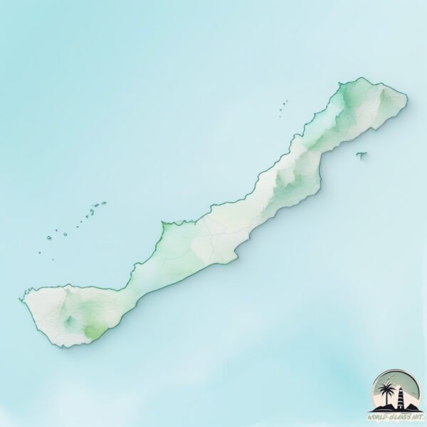
Geography and size of Simushir
Size: 337.1 km²
Coastline: 200.8 km
Ocean: Pacific Ocean
Sea: Sea of Okhotsk
Continent: Asia
Simushir is a Large Island spanning 337 km² with a coastline of 201 km.
Archipel: Kuril Islands – A volcanic archipelago stretching from Japan to Russia, known for their rugged landscapes and abundant marine life.
Tectonic Plate: Okhotsk – Located in the northwest Pacific Ocean, the Okhotsk Plate encompasses the Sea of Okhotsk, the Kamchatka Peninsula, and parts of Japan. It’s involved in complex interactions with the Pacific and North American plates, contributing to seismic activity in the region.
The geographic heart of the island is pinpointed at these coordinates:
Latitude: 46.94919407 / Longitude: 151.99783416
Climate and weather of Simushir
Climate Zone: Polar
Climate Details: Tundra
Temperature: Cold
Climate Characteristics: The tundra climate features long, extremely cold winters and short, cool summers. Vegetation is limited to mosses, lichens, and small shrubs due to the low temperatures and short growing seasons. Biodiversity is low, but some specialized species thrive.
Topography and nature of Simushir
Timezone: UTC+11:00
Timezone places: Asia/Vladivostok
Max. Elevation: 1539 m Milne V.
Mean Elevation: 291 m
Vegetation: Deciduous Broadleaf Forest
Tree Coverage: 44%
The mean elevation is 291 m. Dominating the island’s landscape, the majestic “Milne V.” rises as the highest peak, soaring to impressive heights. The island is characterized by Plateau: Elevated flatlands rising sharply above the surrounding area, with a maximum elevation over 500 meters but a mean elevation less than 300 meters, forming unique highland areas on islands.
Dominating Vegetation: Deciduous Broadleaf Forest
Composed of broadleaf trees that shed their leaves seasonally. These forests are commonly found in temperate zones and experience distinct seasonal changes. Simushir has a tree cover of 44 %.
Vegetation: 11 vegetation zones – Exceptionally Diverse Island
Islands with more than ten vegetation zones are among the most ecologically rich and varied in the world. These islands are akin to miniature continents, boasting an incredible array of ecosystems. The sheer range of habitats, from high peaks to deep valleys, rainforests to deserts, creates a mosaic of life that is unparalleled. They are crucial for conservation and ecological studies.
Infrastructure and Travelling to Simushir
Does the island have a public airport? no.
There is no public and scheduled airport on Simushir. The nearest airport is Iturup Airport, located 452 km away.
Does the island have a major port? no.
There are no major ports on Simushir. The closest major port is SHAKOTAN, approximately 634 km away.
The mean population of Simushir is 1 per km². Simushir is Gently Populated. The island belongs to Russia.
The name of the island resonates across different cultures and languages. Here is how it is known around the world: Arabic: سيموشير; German: Simuschir; Spanish: Simushir; French: Simouchir; Portuguese: Simushir; Russian: Симушир; Chinese: 新知島
Continuing your journey, Ostrov Ketoy is the next notable island, situated merely km away.
The Simushir Island Incident overview


Russia is classified as Emerging region: BRIC: Brazil, Russia, India, and China – Economies noted for their rapid growth and increasing influence on global affairs. The level of income is Upper middle income.
News – Latest Updates and Headlines from Simushir
Stay informed with the most recent news and important headlines from Simushir. Here’s a roundup of the latest developments.
Please note: The data used here has been primarily extracted from satellite readings. Deviations from exact values may occur, particularly regarding the height of elevations and population density. Land area and coastline measurements refer to average values at mean high tide.