Welcome to Smooth Island, a Polar island in the Hudson Strait, part of the majestic Arctic Ocean. This guide offers a comprehensive overview of what makes Smooth Island unique – from its geography and climate to its population, infrastructure, and beyond. Dive into the details:
Geography and size of Smooth Island
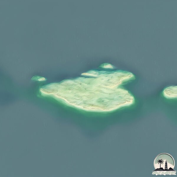
Size: 2.795 km²
Coastline: 9.1 km
Ocean: Arctic Ocean
Sea: Hudson Strait
Continent: North America
Smooth Island is a Small Island spanning 2.8 km² with a coastline of 9.1 km.
Archipel: –
Tectonic Plate: North America – Covers North America and parts of the Atlantic and Arctic Oceans, characterized by diverse geological features and varying levels of seismic activity.
The geographic heart of the island is pinpointed at these coordinates:
Latitude: 62.00154355 / Longitude: -72.28847447
Climate and weather of Smooth Island
Climate Zone: Polar
Climate Details: Tundra
Temperature: Cold
Climate Characteristics: The tundra climate features long, extremely cold winters and short, cool summers. Vegetation is limited to mosses, lichens, and small shrubs due to the low temperatures and short growing seasons. Biodiversity is low, but some specialized species thrive.
Topography and nature of Smooth Island
Timezone: UTC-05:00
Timezone places: America/New_York
Max. Elevation: 78 m
Mean Elevation: 14 m
Vegetation: Herbaceous Cover
Tree Coverage: 73%
The mean elevation is 14 m. The highest elevation on the island reaches approximately 78 meters above sea level. The island is characterized by Plains: Flat, low-lying lands characterized by a maximum elevation of up to 200 meters. On islands, plains are typically coastal lowlands or central flat areas.
Dominating Vegetation: Herbaceous Cover
Comprising mainly of grasses, herbs, and ferns, these areas are common in prairies, meadows, and savannas, and can vary widely in species composition. Smooth Island has a tree cover of 73 %.
Vegetation: 3 vegetation zones – Moderately Diverse Island
These islands start to show a broader range of ecological niches. With three vegetation zones, they may offer a mix of ecosystems like coastal areas, inland woods, and perhaps a distinct wetland or dry area. This diversity supports a wider range of flora and fauna, making these islands more ecologically complex than those with minimal diversity.
Infrastructure and Travelling to Smooth Island
Does the island have a public airport? no.
There is no public and scheduled airport on Smooth Island. The nearest airport is Kangiqsujuaq (Wakeham Bay) Airport, located 59 km away.
Does the island have a major port? no.
There are no major ports on Smooth Island. The closest major port is PANGNIRTUNG, approximately 858 km away.
The mean population of Smooth Island is 0 per km². Smooth Island is Uninhabited. The island belongs to Canada.
Continuing your journey, Maiden Island is the next notable island, situated merely km away.
DJ Smooth Various Artists - Island Reggae Vol 1
Mashup by DJ Smooth Support Dj Smooth in soundcloud and give him thanks! Sound Cloud Link: ...DJ Smooth Various Artists - Island Reggae Vol 1
Mashup by DJ Smooth Support Dj Smooth in soundcloud and give him ...
Mashup by DJ Smooth Support Dj Smooth in soundcloud and give him thanks! Sound Cloud Link: ...
Reggae Lovers Rock – Timeless Love Songs & Smooth Island Vibes
Fall into the warmth of Lovers Rock reggae with this sweet and soulful ...
Fall into the warmth of Lovers Rock reggae with this sweet and soulful Reggae Lovers Rock Hits Mix — a blend of timeless ...
🌴 Smooth Island Reggae 🏖️ Tropical Chill Vibes & Positive Energy 🌺💫
Smooth Island Reggae 🏖️ Tropical Chill Vibes & Positive Energy Welcome ...
Smooth Island Reggae 🏖️ Tropical Chill Vibes & Positive Energy Welcome to Reggae Wave Hawaii! Your island ...
🌊 Hawaiian Reggae Chill Vibes – Smooth Island Music for Focus 🌴
Relax into Hawaiian Reggae Chill, where soft island grooves and gentle ...
Relax into Hawaiian Reggae Chill, where soft island grooves and gentle reggae rhythms bring a sense of peace, light, and warm ...
Aloha Reggae Vibes 🌞 Smooth Island Grooves to Lift Your Mood 🌊
Aloha Reggae Vibes Smooth Island Grooves to Lift Your Mood ...
🌺 Hawaiian Chill Reggae – Smooth Island Grooves for Peace & Sunshine 🌴
Hawaiian Chill Reggae – Smooth Island Grooves for Peace & Sunshine ...
Hawaiian Chill Reggae – Smooth Island Grooves for Peace & Sunshine Drift into a world of calm and sunshine with Hawaiian ...
🌺 Smooth Island Aloha – Warm Reggae Beats for Happiness 🌊
Smooth Island Aloha – Warm Reggae Beats for Happiness Immerse yourself ...
Smooth Island Aloha – Warm Reggae Beats for Happiness Immerse yourself in the gentle warmth of island-inspired reggae ...
New Reggae Flow 2026 | Smooth Island Style
Welcome to Jamaica Reggae Flow — the place where real reggae vibes ...
Welcome to Jamaica Reggae Flow — the place where real reggae vibes come alive This channel is dedicated to authentic ...
You’ll Fall in Love With This Reggae Playlist 💛 | Smooth Island Vibes
SoulTide Reggae presents another original reggae ballad — blending ...
SoulTide Reggae presents another original reggae ballad — blending heartfelt emotion, smooth rhythm, and soulful vibes.
LIVE Caribbean Reggae 24/7 🌴 Smooth Island Chill for Beach Bars & Cafe Vibes
Relax and enjoy smooth reggae music with tropical island vibes. This ...
Relax and enjoy smooth reggae music with tropical island vibes. This reggae playlist is perfect for chilling, studying, working, ...
🌺 Aloha Tropical Reggae – Smooth Island Sounds for Peace & Joy 🌞
Aloha Tropical Reggae – Smooth Island Sounds for Peace & Joy Let the ...
Aloha Tropical Reggae – Smooth Island Sounds for Peace & Joy Let the spirit of aloha guide you into a calm and joyful state ...
Best Reggae Live Stream 2026 🌊 Smooth Island Chill Music for Relax Study and Ocean Breeze Mood
Relax with the most relaxing Beach Reggae Session. This collection ...
Relax with the most relaxing Beach Reggae Session. This collection brings you peaceful island melodies. Perfect for sleeping ...
🌺 Tropical Aloha Reggae – Smooth Island Sounds for Peace & Joy 🌞
Tropical Aloha Reggae – Smooth Island Sounds for Peace & Joy ...
Tropical Aloha Reggae – Smooth Island Sounds for Peace & Joy Experience the warm and uplifting spirit of aloha through ...
Chill Tropical Beach Reggae 2026 Smooth Island Playlist for Relaxation and Ocean Breeze
Enjoy the beautiful Beach Reggae Session. This collection brings you ...
Enjoy the beautiful Beach Reggae Session. This collection brings you soft chill reggae vibes. Great for sleeping while enjoying ...
Smooth Island Chill Reggae 2026 Tropical Beach Music for Relaxation and Sunset Energy
Experience the beautiful Island Reggae Vibes. This mix brings you ...
Experience the beautiful Island Reggae Vibes. This mix brings you smooth reggae rhythms. Perfect for studying while enjoying ...
Smooth Island
Provided to YouTube by Ditto Music Smooth Island · Rynsa Man ...
Provided to YouTube by Ditto Music Smooth Island · Rynsa Man Smoothstrumentals Vol.3 ℗ Rynsa Man Released on: ...
After Dark Island Vibes – Smooth Reggae Fusion
Welcome to Island Fusion Vibes Experience the perfect blend of Reggae ...
Welcome to Island Fusion Vibes Experience the perfect blend of Reggae Fusion, Tropical Chill, and Island Night Grooves.
Classic Roots Reggae Live 2026 – Smooth Island Chill Tunes for Relaxation
reggaemusic #reggaesongs #rootsreggae Hey there, welcome to Luckenbach ...
reggaemusic #reggaesongs #rootsreggae Hey there, welcome to Luckenbach Music — your peaceful corner for sunshine ...
Smooth Island Grooves
Provided to YouTube by DistroKid Smooth Island Grooves · Fusion ...
Provided to YouTube by DistroKid Smooth Island Grooves · Fusion Collective Reggae Jazz ℗ Drope Records Released on: ...
Why People in the Canary Islands Use Sticks for Cliff Jumping 😯 #jump
This simple pole might look ordinary, but it's one of the smartest ...
This simple pole might look ordinary, but it's one of the smartest survival tools ever used. In the Canary Islands, people use a long ...
Hawaiian Reggae Paradise 🌴 Smooth Island Reggae for Relaxing and Good Vibes
Welcome to Hawaiian Reggae Chill 2026 Immerse yourself in smooth ...
Welcome to Hawaiian Reggae Chill 2026 Immerse yourself in smooth Hawaiian reggae sounds. This Hawaiian reggae chill ...
Best Reggae Love Songs 2026 💥 Smooth Island Chill Mix 🌴 Relaxing Romantic Vibes
Welcome to the ultimate collection of the Best Reggae Love Songs 2026 ...
Welcome to the ultimate collection of the Best Reggae Love Songs 2026 — a smooth island chill mix filled with relaxing romantic ...
Island Blue - Smooth Island Blue
An original from CNMI's very own ISLAND BLUE! Check em out everybody. ...
An original from CNMI's very own ISLAND BLUE! Check em out everybody. They are HUNGRY!! Island Blue Members: Nickson ...
Ultimate Reggae Love Mix 2026 💛 Smooth Island Chill & Romantic Vibes
Welcome to Ultimate Reggae Love Mix 2026 This mix brings together ...
Welcome to Ultimate Reggae Love Mix 2026 This mix brings together smooth reggae love songs, tropical island grooves, and ...
Smooth Island Groovin' (Instrumental)
Provided to YouTube by CDBaby Smooth Island Groovin' (Instrumental) · ...
Provided to YouTube by CDBaby Smooth Island Groovin' (Instrumental) · Bashir Inspired Swagger (Instrumentals) ℗ 2017 Bashir ...
Canada is classified as Developed region: G7: Group of Seven – Major advanced economies, including Canada, France, Germany, Italy, Japan, the United Kingdom, and the United States. The level of income is High income: OECD.
News – Latest Updates and Headlines from Smooth Island
Stay informed with the most recent news and important headlines from Smooth Island. Here’s a roundup of the latest developments.
Loading...
Please note: The data used here has been primarily extracted from satellite readings. Deviations from exact values may occur, particularly regarding the height of elevations and population density. Land area and coastline measurements refer to average values at mean high tide.