Welcome to Sola, a Temperate island in the Norwegian Sea, part of the majestic Arctic Ocean. This guide offers a comprehensive overview of what makes Sola unique – from its geography and climate to its population, infrastructure, and beyond. Dive into the details:
Geography and size of Sola
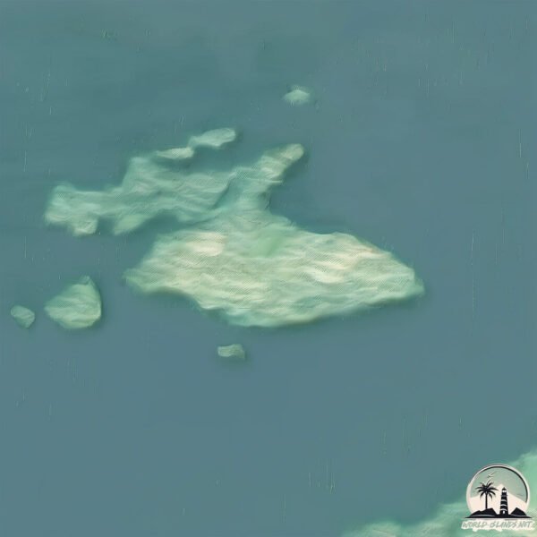
Size: 3.082 km²
Coastline: 8.7 km
Ocean: Arctic Ocean
Sea: Norwegian Sea
Continent: Europe
Sola is a Small Island spanning 3.1 km² with a coastline of 8.7 km.
Archipel: –
Tectonic Plate: Eurasia – One of the world’s largest tectonic plates, the Eurasian Plate covers a significant portion of Europe and Asia. It’s characterized by diverse geological features, including the Ural Mountains, the European Plain, and the Himalayas formed from its collision with the Indian Plate.
The geographic heart of the island is pinpointed at these coordinates:
Latitude: 65.66924473 / Longitude: 11.72997289
Climate and weather of Sola
Climate Zone: Temperate
Climate Details: Temperate Oceanic Climate
Temperature: Warm Summer
Climate Characteristics: Known for its moderate year-round temperatures with ample rainfall and no dry season. Warm summers are characteristic.
Topography and nature of Sola
Timezone: UTC+01:00
Timezone places: Europe/Paris
Max. Elevation: 298 m
Mean Elevation: 119 m
Vegetation: Evergreen Needleleaf Forest
Tree Coverage: 88%
The mean elevation is 119 m. The highest elevation on the island reaches approximately 298 meters above sea level. The island is characterized by Hills: Gently sloping landforms with rounded tops, having a maximum elevation between 200 and 500 meters. Hills contribute to a varied landscape on islands.
Dominating Vegetation: Evergreen Needleleaf Forest
Dominated by evergreen coniferous trees such as pines and firs, which retain their needle-like leaves throughout the year. These forests are often found in cooler climates. Sola has a tree cover of 88 %.
Vegetation: 5 vegetation zones – Highly Diverse Island
With five different vegetation zones, these islands offer a rich tapestry of ecosystems. The variety could include dense forests, open meadows, wetlands, coastal zones, and more. This level of diversity supports an intricate web of life, with each zone playing a vital role in the overall ecological health and balance of the island.
Infrastructure and Travelling to Sola
Does the island have a public airport? no.
There is no public and scheduled airport on Sola. The nearest airport is Brønnøysund Airport, Brønnøy, located 56 km away.
Does the island have a major port? no.
There are no major ports on Sola. The closest major port is BRONNOYSUND, approximately 54 km away.
The mean population of Sola is 8 per km². Sola is Gently Populated. The island belongs to Norway.
Continuing your journey, Vega is the next notable island, situated merely km away.
Dead Island 2 - SoLA Launch Trailer | PS5 & PS4 Games
Dead Island 2's second expansion story – SoLA – is out now on PlayStation. Stage dive into the heart of SoLA, the ultimate ...Dead Island 2 - SoLA Launch Trailer | PS5 & PS4 Games
Dead Island 2's second expansion story – SoLA – is out now on ...
Dead Island 2's second expansion story – SoLA – is out now on PlayStation. Stage dive into the heart of SoLA, the ultimate ...
La donna che vive in un'isola da sola in mezzo alla natura (e che vista!)
Sull'isola d'Elba, su una collina affacciata sul mare, Silvia ha ...
Sull'isola d'Elba, su una collina affacciata sul mare, Silvia ha deciso di provare a vivere in modo diverso. Dopo anni passati tra ...
DO NOT Buy Dead Island 2 SOLA Festival DLC!
DO NOT Buy Dead Island 2 SOLA Festival DLC! So they've released the ...
DO NOT Buy Dead Island 2 SOLA Festival DLC! So they've released the 2nd story DLC for Dead Island 2 called the SOLA ...
If A Zombie Comes Into Your Safe House - DEAD ISLAND 2 SoLA DLC Gameplay #DeadIsland2 #Game #gaming
Dead Island 2: SOLA DLC Zombie Comes Into Safe House - Ryan Single ...
Dead Island 2: SOLA DLC Zombie Comes Into Safe House - Ryan Single Player Gameplay Full Game Walkthrough Long Play ...
New Dead Island 2 Update DLC Is Disappointing
New Dead Island 2 Update DLC Is Disappointing This Dying Light 2, Days ...
New Dead Island 2 Update DLC Is Disappointing This Dying Light 2, Days Gone 2, and/or Dead Island 2 video will discuss New ...
Dead Island 2: SoLA DLC Was Nothing Special - Honest Review!
Sharing my review for Dead Island 2: SoLA DLC... ✔️ Please Consider ...
Sharing my review for Dead Island 2: SoLA DLC... ✔️ Please Consider Supporting me on my Patreon: ...
Dead Island 2 SoLA Launch Trailer
Dead Island 2's second expansion story – SoLA – is out now on Xbox. ...
Dead Island 2's second expansion story – SoLA – is out now on Xbox. Stage dive into the heart of SoLA, the ultimate Californian ...
New Apex Variant: WHIPPERS First Encounter - DEAD ISLAND 2 SoLA DLC Gameplay #DeadIsland
Dead Island 2 SOLA DLC All Boss Fights Gameplay No Commentary. DEAD ...
Dead Island 2 SOLA DLC All Boss Fights Gameplay No Commentary. DEAD ISLAND 2 SOLA Update new apex variants, All Boss ...
Did Jacob just SMACK that girl? | Dead Island 2 Sola DLC #shorts
if you like the video feel free to subscribe 🙂 #deadisland2 #soladlc.
if you like the video feel free to subscribe 🙂 #deadisland2 #soladlc.
DEAD ISLAND 2 SOLA DLC Walkthrough Gameplay Part 1 - INTRO (FULL GAME)
All *NEW* Zombie Types in Dead Island 2: SOLA DLC Guide
All new zombie types in Dead Island 2: SOLA dlc - These are all the ...
All new zombie types in Dead Island 2: SOLA dlc - These are all the new zombie variants in Dead Island 2's SOLA dlc (including 2 ...
Dead Island 2 - Sola - Free Roam Gameplay #320 [4K HDR 60FPS]
Dead island 2 relaxing gameplay killing zombies Thank you for watching ...
Dead island 2 relaxing gameplay killing zombies Thank you for watching my free roam gameplay video and don't forget to like, ...
Dead Island 2 – SoLA – Launch Trailer
Dead Island 2's second expansion story – SoLA – is out now on Xbox, ...
Dead Island 2's second expansion story – SoLA – is out now on Xbox, PlayStation and PC. Stage dive into the heart of SoLA, the ...
Dead Island 2 - Sola - Free Roam Gameplay #315 [4K HDR 60FPS]
Dead island 2 relaxing gameplay killing zombies Thank you for watching ...
Dead island 2 relaxing gameplay killing zombies Thank you for watching my free roam gameplay video and don't forget to like, ...
DEAD ISLAND 2 SOLA DLC Walkthrough Gameplay Part 2 - NIGHTCLUB (FULL GAME)
Dead Island 2 SOLA DLC Walkthrough Gameplay Part 2 includes Full ...
Dead Island 2 SOLA DLC Walkthrough Gameplay Part 2 includes Full Gameplay, Full Game Review and Campaign Story Mission ...
DEAD ISLAND 2 SOLA DLC Full Gameplay Walkthrough / No Commentary【FULL GAME】4K Ultra HD
DEAD ISLAND 2 SOLA DLC Full Gameplay Walkthrough / No Commentary【FULL ...
DEAD ISLAND 2 SOLA DLC Full Gameplay Walkthrough / No Commentary【FULL GAME】4K Ultra HD includes the full story, ...
All Special Weapons - DEAD ISLAND 2 SoLA Gameplay #DeadIsland #DeadIsland2 #Gaming #Game
Dead Island 2: SOLA DLC All Special / Secret New Weapon Location Guide ...
Dead Island 2: SOLA DLC All Special / Secret New Weapon Location Guide & Showcases Walkthrough from Side Quest Flesh ...
DEAD ISLAND 2 SOLA DLC All Cutscenes (Full Game Movie) 4K 60FPS Ultra HD
DEAD ISLAND 2 SOLA DLC All Cutscenes (Full Game Movie) 4K 60FPS Ultra ...
DEAD ISLAND 2 SOLA DLC All Cutscenes (Full Game Movie) 4K 60FPS Ultra HD DESCRIPTION A deadly virus sweeps ...
Dead Island 2 – Official SoLA Expansion Gameplay Launch Trailer
Dead Island 2's second expansion story – SoLA – is out now on Xbox, ...
Dead Island 2's second expansion story – SoLA – is out now on Xbox, PlayStation and PC. Stage dive into the heart of SoLA, the ...
Dead Island 2 LIED 😞... #shorts #deadisland2
Dead Island 2 LIED to Us... #shorts #deadisland2.
Dead Island 2 LIED to Us... #shorts #deadisland2.
New Dead Island 2 "Sola Festival" DLC Update - Full Gameplay, Review
New Dead Island 2 "Sola Festival" DLC - Review & First Impressions ...
New Dead Island 2 "Sola Festival" DLC - Review & First Impressions (Full Gameplay) Tip me: ...
Dead islands 2 Sola dlc The Dirge cutscenes
gaming #deadislands2.
gaming #deadislands2.
The Dead Island 2 Sola DLC Is Exactly What I Wanted — My Honest Thoughts & Expectations
I knew the Sola DLC would be interesting, but the latest info gave us ...
I knew the Sola DLC would be interesting, but the latest info gave us a better idea of what to expect (and I loved almost everything ...
¿Nueva facción o Slayers en DEAD ISLAND 2 SOLA FESTIVAL?
JesuSaleme.
JesuSaleme.
Rating Dead Island 2 After 2 years #deadisland2 #deadisland #ratinggames
Rating Dead Island 2 After 2 years Dead Island 2 Edit Game: Dead ...
Rating Dead Island 2 After 2 years Dead Island 2 Edit Game: Dead Island 2 #deadisland2 #deadisland #deadisland2ps5 ...
Norway is classified as Developed region: nonG7: Developed economies outside of the Group of Seven, characterized by high income and advanced economic structures. The level of income is High income: OECD.
News – Latest Updates and Headlines from Sola
Stay informed with the most recent news and important headlines from Sola. Here’s a roundup of the latest developments.
Loading...
Please note: The data used here has been primarily extracted from satellite readings. Deviations from exact values may occur, particularly regarding the height of elevations and population density. Land area and coastline measurements refer to average values at mean high tide.


![Dead Island 2 - Sola - Free Roam Gameplay #320 [4K HDR 60FPS]](https://i.ytimg.com/vi/_SGaAX3SPyg/mqdefault.jpg)

![Dead Island 2 - Sola - Free Roam Gameplay #315 [4K HDR 60FPS]](https://i.ytimg.com/vi/t2CYGQ-KRdI/mqdefault.jpg)


