Sona Char
Welcome to Sona Char, a Tropical island in the Bay of Bengal, part of the majestic Indian Ocean. This guide offers a comprehensive overview of what makes Sona Char unique – from its geography and climate to its population, infrastructure, and beyond. Dive into the details:
- Geography and Size: Explore the island’s size and location.
- Climate and Weather: Weather patterns and temperature.
- Topography and Nature: Uncover the natural wonders of the island.
- Infrastructure and Travelling: Insights on reaching, staying, and making the most of your visit.
- News and Headlines: Latest News.
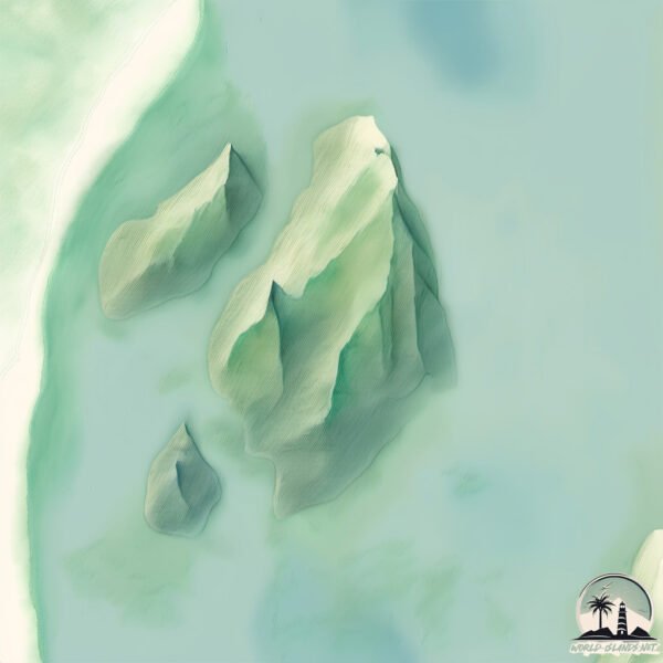
Geography and size of Sona Char
Size: 10.3 km²
Coastline: 15.8 km
Ocean: Indian Ocean
Sea: Bay of Bengal
Continent: Asia
Sona Char is a Medium Island spanning 10 km² with a coastline of 16 km.
Archipel: –
Tectonic Plate: India – A major tectonic plate that initially moved northward at a rapid pace before colliding with the Eurasian Plate. This collision is responsible for the uplift of the Himalayas and the Tibetan Plateau.
The geographic heart of the island is pinpointed at these coordinates:
Latitude: 22.36172372 / Longitude: 90.88126233
Climate and weather of Sona Char
Climate Zone: Tropical
Climate Details: Tropical Monsoon Climate
Temperature: Hot
Climate Characteristics: Characterized by heavy rainfall, high humidity, and uniformly high temperatures, but with a distinct short dry season. It features a seasonal reversal of prevailing wind directions.
Topography and nature of Sona Char
Timezone: UTC+06:00
Timezone places: Asia/Dhaka
Max. Elevation: 2 m
Mean Elevation: -1 m
Vegetation: Rice Paddy
Tree Coverage: 22%
The mean elevation is -1 m. The highest elevation on the island reaches approximately 2 meters above sea level. The island is characterized by Plains: Flat, low-lying lands characterized by a maximum elevation of up to 200 meters. On islands, plains are typically coastal lowlands or central flat areas.
Dominating Vegetation: Rice Paddy
Specifically designed for rice cultivation, these fields are flooded with water during the growing season. Paddy fields are a common sight in many parts of Asia. Sona Char has a tree cover of 22 %.
Vegetation: 8 vegetation zones – Very Highly Diverse Island
Islands in this range are ecological powerhouses, showcasing a wide array of vegetation zones. Each zone, from lush rainforests to arid scrublands, coastal mangroves to mountainous regions, contributes to a complex and interdependent ecosystem. These islands are often hotspots of biodiversity, supporting numerous species and intricate ecological processes.
Infrastructure and Travelling to Sona Char
Does the island have a public airport? no.
There is no public and scheduled airport on Sona Char. The nearest airport is Barisal Airport, located 79 km away.
Does the island have a major port? no.
There are no major ports on Sona Char. The closest major port is CHITTAGONG, approximately 103 km away.
The mean population of Sona Char is 1958 per km². Sona Char is Densely Populated. The island belongs to Bangladesh.
Continuing your journey, Bhola is the next notable island, situated merely km away.
Kids Making Object Shows Be like.. #shorts


![Who Are You? | Smiling Critters [Poppy Playtime]](https://i.ytimg.com/vi/L6TEhTFA2CA/mqdefault.jpg)


Bangladesh is classified as Least developed region: Countries that exhibit the lowest indicators of socioeconomic development, with the lowest Human Development Index ratings. The level of income is Low income.
News – Latest Updates and Headlines from Sona Char
Stay informed with the most recent news and important headlines from Sona Char. Here’s a roundup of the latest developments.
Please note: The data used here has been primarily extracted from satellite readings. Deviations from exact values may occur, particularly regarding the height of elevations and population density. Land area and coastline measurements refer to average values at mean high tide.