Welcome to Sotra, a Temperate island in the North Sea, part of the majestic Atlantic Ocean. This guide offers a comprehensive overview of what makes Sotra unique – from its geography and climate to its population, infrastructure, and beyond. Dive into the details:
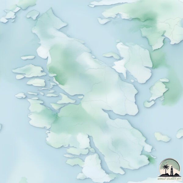
Geography and size of Sotra
Size: 203.8 km²
Coastline: 227.9 km
Ocean: Atlantic Ocean
Sea: North Sea
Continent: Europe
Sotra is a Large Island spanning 204 km² with a coastline of 228 km.
Archipel: –
Tectonic Plate: Eurasia – One of the world’s largest tectonic plates, the Eurasian Plate covers a significant portion of Europe and Asia. It’s characterized by diverse geological features, including the Ural Mountains, the European Plain, and the Himalayas formed from its collision with the Indian Plate.
The geographic heart of the island is pinpointed at these coordinates:
Latitude: 60.30303163 / Longitude: 5.05840912
Climate and weather of Sotra
Climate Zone: Temperate
Climate Details: Temperate Oceanic Climate
Temperature: Warm Summer
Climate Characteristics: Known for its moderate year-round temperatures with ample rainfall and no dry season. Warm summers are characteristic.
Topography and nature of Sotra
Timezone: UTC+01:00
Timezone places: Europe/Paris
Max. Elevation: 328 m
Mean Elevation: 100 m
Vegetation: Evergreen Needleleaf Forest
Tree Coverage: 64%
The mean elevation is 100 m. The highest elevation on the island reaches approximately 328 meters above sea level. The island is characterized by Hills: Gently sloping landforms with rounded tops, having a maximum elevation between 200 and 500 meters. Hills contribute to a varied landscape on islands.
Dominating Vegetation: Evergreen Needleleaf Forest
Dominated by evergreen coniferous trees such as pines and firs, which retain their needle-like leaves throughout the year. These forests are often found in cooler climates. Sotra has a tree cover of 64 %.
Vegetation: 11 vegetation zones – Exceptionally Diverse Island
Islands with more than ten vegetation zones are among the most ecologically rich and varied in the world. These islands are akin to miniature continents, boasting an incredible array of ecosystems. The sheer range of habitats, from high peaks to deep valleys, rainforests to deserts, creates a mosaic of life that is unparalleled. They are crucial for conservation and ecological studies.
Infrastructure and Travelling to Sotra
Does the island have a public airport? no.
There is no public and scheduled airport on Sotra. The nearest airport is Bergen Airport, Flesland, located 8 km away.
Does the island have a major port? yes.
Sotra is home to a major port. The following ports are situated on the island: .
The mean population of Sotra is 159 per km². Sotra is Moderately Inhabited. The island belongs to Norway.
Continuing your journey, Hundvako is the next notable island, situated merely km away.
A trip to Island Sotra 🇳🇴 #sotra #island
Island Sotra, located off the western coast of Norway, is a captivating destination that offers a harmonious blend of rugged coastal ...A trip to Island Sotra 🇳🇴 #sotra #island
Island Sotra, located off the western coast of Norway, is a ...
Island Sotra, located off the western coast of Norway, is a captivating destination that offers a harmonious blend of rugged coastal ...
COUNTRYSIDE DRIVE AROUND SOTRA ISLAND - NORWAY
Driving along the coast of the Norwegian island, Sotra. The island is ...
Driving along the coast of the Norwegian island, Sotra. The island is situated west of Bergen city. Daytime vs nighttime drive.
Driving in Norway 🇧🇻Short drive from Bergen to Sotra /Filipina life in Norway /Analy MC
Sotra The island by the sea // FB Productions
Sotra, an island of beauty by the sea, with a buzzing sea life and ...
Sotra, an island of beauty by the sea, with a buzzing sea life and capricious coves makes it one of Norway's hidden gems. All the ...
SOTRA Island / Norway 4K
Sunset's on SOTRA island Vestland (Hordaland) - Norway / Norge ...
Sunset's on SOTRA island Vestland (Hordaland) - Norway / Norge (Feeling of relaxation)
Norway - Island of Sotra - Telavåg & Glesvær - DJI Mavic Air - 4K
Drone footage of my recent holiday to Norway. Footage includes Telavåg ...
Drone footage of my recent holiday to Norway. Footage includes Telavåg & Glesvær on the island of Sotra of Norway. Music by ...
Exploring Norway's Most Unique Island: Sotra
Join me on an unforgettable adventure as I explore Norway's most ...
Join me on an unforgettable adventure as I explore Norway's most unique island, Sotra! Growing up, I spent countless hours ...
Nearly 500 evacuated as firefighters battle huge wildfire in Norway
Fire services on Friday (June 4) continued to battle a fire on the ...
Fire services on Friday (June 4) continued to battle a fire on the island of Sotra on Norway's west coast. The fire started on ...
Driving in Norway: Sotra - Øygarden
Enjoy a beautiful scenery on this drive across the islands on the west ...
Enjoy a beautiful scenery on this drive across the islands on the west coast of Norway. Sotra and Øygarden is located just outside ...
Golden hour at Hellesøy Island - Sotra (DJI Spark)
Golden hour and sunset at the beautiful area of Hellesøy, in Øygarden. ...
Golden hour and sunset at the beautiful area of Hellesøy, in Øygarden. This place all the way north on the Sotra Island is ...
Island Adventure off the Coast of Bergen, Norway
Sotra, An island near Bergen, known for its beautiful nature, and opportunities for fishing #norway
Rogn being a settlement and administrative center in Øygarden ...
Rogn being a settlement and administrative center in Øygarden municipality, located near Bergen, Norway.; - *Rong*: A prioritized ...
Se hvordan Sartor Storsenter og Sotra Kystby vokser frem!
Mer info om Sotra Kystby får du ved å besøke Sotra Kystby Infosenter i ...
Mer info om Sotra Kystby får du ved å besøke Sotra Kystby Infosenter i Sotra Minimarked (tidligere Gjensidige), eller se ...
Big Waves Sotra after storm in Norway 4th of February 2011 By Allen Vedeler
Filmed by the coastline at Golta, Sotra outside Bergen Norway. Day ...
Filmed by the coastline at Golta, Sotra outside Bergen Norway. Day after big storm. All rights: Allen Vedeler 2011.
Angeln in Norwegen: Heggøy Rorbuer - Pollack-Paradies vor der Insel Sotra bei Bergen
Die Insel Sotra in Westnorwegen ist Garant für eine tolle Angelei auf ...
Die Insel Sotra in Westnorwegen ist Garant für eine tolle Angelei auf Dorsch, Köhler, Leng, Lumb und vor allen Dingen Pollack.
Socotra Island: The Alien-Looking Place on Earth That Feels Like Another Planet@CineCurioLab
Socotra Island is one of the most unique places on Earth, known for ...
Socotra Island is one of the most unique places on Earth, known for its strange landscapes and rare plant species found nowhere ...
Common Whitethroat warbler young | summer on Sotra Island Norway
Common Whitethroat (Sylvia communis; Tornsanger) fledgling/juvenile on ...
Common Whitethroat (Sylvia communis; Tornsanger) fledgling/juvenile on Sotra island, west of Bergen, Norway. Mid-July.
From Bergen to Sotra. Fjords & roads
Podróż z Bergen na zachód, na archipelag Sotra nad Morzem Północnym i ...
Podróż z Bergen na zachód, na archipelag Sotra nad Morzem Północnym i na północ (Droga Atlantycka). Po drodze umocnienia ...
Glesvær, Norway, is a charming coastal village located on the island of Sotra #visitnorway #youtube
Must visit Places in Norway
SAVE this for your Norway trip and SHARE it with someone travelling to ...
SAVE this for your Norway trip and SHARE it with someone travelling to Norway From breathtaking fjords to stunning landscapes, ...
Night Bergen beautiful bridge island Sotra and island Askoy
Night Bergen beautiful bridge island Sotra and island Askoy.
Night Bergen beautiful bridge island Sotra and island Askoy.
Crab Fishing at Sotra, Western Norway
This beautiful day we went crab fishing with our friends in Bergen. We ...
This beautiful day we went crab fishing with our friends in Bergen. We went to Bildøyna at Sotra and we were quite lucky with the ...
Turøy Norway#aquabound #gopro #goprohero12 #boundbyadventure #seakayaking #kajakk #kayak #sotra
Norway is classified as Developed region: nonG7: Developed economies outside of the Group of Seven, characterized by high income and advanced economic structures. The level of income is High income: OECD.
News – Latest Updates and Headlines from Sotra
Stay informed with the most recent news and important headlines from Sotra. Here’s a roundup of the latest developments.
Loading...
Please note: The data used here has been primarily extracted from satellite readings. Deviations from exact values may occur, particularly regarding the height of elevations and population density. Land area and coastline measurements refer to average values at mean high tide.