South Georgia and the South Sandwich Islands
Welcome to South Georgia and the South Sandwich Islands, a Polar island in the South Atlantic Ocean, part of the majestic Atlantic Ocean. This guide offers a comprehensive overview of what makes South Georgia and the South Sandwich Islands unique – from its geography and climate to its population, infrastructure, and beyond. Dive into the details:
- Geography and Size: Explore the island’s size and location.
- Climate and Weather: Weather patterns and temperature.
- Topography and Nature: Uncover the natural wonders of the island.
- Infrastructure and Travelling: Insights on reaching, staying, and making the most of your visit.
- News and Headlines: Latest News.
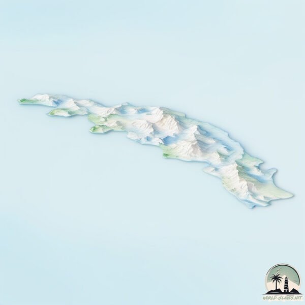
Geography and size of South Georgia and the South Sandwich Islands
Size: 3561 km²
Coastline: 1219 km
Ocean: Atlantic Ocean
Sea: South Atlantic Ocean
Continent: Seven seas (open ocean)
South Georgia and the South Sandwich Islands is a Very Large Island spanning 3561 km² with a coastline of 1219 km.
Archipel: South Georgia and the South Sandwich Islands – Remote British overseas territories in the southern Atlantic Ocean, known for their rugged terrain, abundant wildlife, and historical significance.
Tectonic Plate: South America – A major plate covering the South American continent and part of the Atlantic Ocean, known for the Andes mountain range and significant seismic and volcanic activity.
The geographic heart of the island is pinpointed at these coordinates:
Latitude: -54.37869694 / Longitude: -36.68068517
Climate and weather of South Georgia and the South Sandwich Islands
Climate Zone: Polar
Climate Details: Tundra
Temperature: Cold
Climate Characteristics: The tundra climate features long, extremely cold winters and short, cool summers. Vegetation is limited to mosses, lichens, and small shrubs due to the low temperatures and short growing seasons. Biodiversity is low, but some specialized species thrive.
Topography and nature of South Georgia and the South Sandwich Islands
Timezone: UTC-02:00
Timezone places: Atlantic/South_Georgia
Max. Elevation: 2934 m Mt. Paget
Mean Elevation: 510 m
Vegetation: Snow and Ice Covered
Tree Coverage: 27%
The mean elevation is 510 m. Dominating the island’s landscape, the majestic “Mt. Paget” rises as the highest peak, soaring to impressive heights. The island is characterized by Mountains: High, steeply elevated landforms. Characterized by both a high maximum elevation (over 500 meters) and a high mean elevation, creating rugged, mountainous terrains on islands.
Dominating Vegetation: Snow and Ice Covered
These areas are permanently or seasonally covered in snow and ice, with little to no vegetation, such as polar regions and high mountains. South Georgia and the South Sandwich Islands has a tree cover of 27 %.
Vegetation: 15 vegetation zones – Exceptionally Diverse Island
Islands with more than ten vegetation zones are among the most ecologically rich and varied in the world. These islands are akin to miniature continents, boasting an incredible array of ecosystems. The sheer range of habitats, from high peaks to deep valleys, rainforests to deserts, creates a mosaic of life that is unparalleled. They are crucial for conservation and ecological studies.
Infrastructure and Travelling to South Georgia and the South Sandwich Islands
Does the island have a public airport? no.
There is no public and scheduled airport on South Georgia and the South Sandwich Islands. The nearest airport is Port Stanley Airport, located 2211 km away.
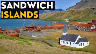
Does the island have a major port? yes.
South Georgia and the South Sandwich Islands is home to a major port. The following ports are situated on the island: STROMNESS HARBOR, GRYTVIKEN.
The mean population of South Georgia and the South Sandwich Islands is per km². South Georgia and the South Sandwich Islands is . The island belongs to United Kingdom.
The name of the island resonates across different cultures and languages. Here is how it is known around the world: Arabic: جزيرة جورجيا الجنوبية; German: Südgeorgien; Spanish: San Pedro; French: île de Géorgie du Sud; Portuguese: Geórgia do Sul; Russian: Южная Георгия; Chinese: 南喬治亞島
Continuing your journey, Coronation is the next notable island, situated merely km away.
What on Earth are the Sandwich Islands?
United Kingdom is classified as Developed region: G7: Group of Seven – Major advanced economies, including Canada, France, Germany, Italy, Japan, the United Kingdom, and the United States. The level of income is High income: OECD.
News – Latest Updates and Headlines from South Georgia and the South Sandwich Islands
Stay informed with the most recent news and important headlines from South Georgia and the South Sandwich Islands. Here’s a roundup of the latest developments.
Social Media Posts about South Georgia and the South Sandwich Islands
Please note: The data used here has been primarily extracted from satellite readings. Deviations from exact values may occur, particularly regarding the height of elevations and population density. Land area and coastline measurements refer to average values at mean high tide.