Welcome to Spicer, a Temperate island in the The Northwestern Passages, part of the majestic Pacific Ocean. This guide offers a comprehensive overview of what makes Spicer unique – from its geography and climate to its population, infrastructure, and beyond. Dive into the details:
Geography and size of Spicer
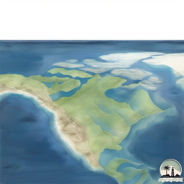
Size: 12.2 km²
Coastline: 27.4 km
Ocean: Pacific Ocean
Sea: The Northwestern Passages
Continent: North America
Spicer is a Medium Island spanning 12 km² with a coastline of 27 km.
Archipel: Canadian Arctic Archipelago – A vast and remote region in northern Canada, consisting of a series of large and small islands known for their extreme Arctic environment and unique wildlife.
Tectonic Plate: North America – Covers North America and parts of the Atlantic and Arctic Oceans, characterized by diverse geological features and varying levels of seismic activity.
The geographic heart of the island is pinpointed at these coordinates:
Latitude: 59.61596943 / Longitude: -103.42086884
Climate and weather of Spicer
Climate Zone: Temperate
Climate Details: Temperate Oceanic Climate
Temperature: Warm Summer
Climate Characteristics: Known for its moderate year-round temperatures with ample rainfall and no dry season. Warm summers are characteristic.
Topography and nature of Spicer
Timezone: UTC-08:00
Timezone places: America/Los_Angeles
Max. Elevation: 98 m
Mean Elevation: 3 m
Vegetation: Evergreen Needleleaf Forest
Tree Coverage: 72%
The mean elevation is 3 m. The highest elevation on the island reaches approximately 98 meters above sea level. The island is characterized by Plains: Flat, low-lying lands characterized by a maximum elevation of up to 200 meters. On islands, plains are typically coastal lowlands or central flat areas.
Dominating Vegetation: Evergreen Needleleaf Forest
Dominated by evergreen coniferous trees such as pines and firs, which retain their needle-like leaves throughout the year. These forests are often found in cooler climates. Spicer has a tree cover of 72 %.
Vegetation: 9 vegetation zones – Very Highly Diverse Island
Islands in this range are ecological powerhouses, showcasing a wide array of vegetation zones. Each zone, from lush rainforests to arid scrublands, coastal mangroves to mountainous regions, contributes to a complex and interdependent ecosystem. These islands are often hotspots of biodiversity, supporting numerous species and intricate ecological processes.
Infrastructure and Travelling to Spicer
Does the island have a public airport? no.
There is no public and scheduled airport on Spicer. The nearest airport is Prince Rupert Airport, located 56 km away.
Does the island have a major port? no.
There are no major ports on Spicer. The closest major port is PORPOISE HARBOR, approximately 49 km away.
The mean population of Spicer is 0 per km². Spicer is Uninhabited. The island belongs to Canada.
Continuing your journey, Dolphin is the next notable island, situated merely km away.
This is the World's Most Remote Island..
The World's Most Remote Islands are the Pitcairn Islands located in the south pacific ocean. The town here is known as ...This is the World's Most Remote Island..
The World's Most Remote Islands are the Pitcairn Islands located in ...
The World's Most Remote Islands are the Pitcairn Islands located in the south pacific ocean. The town here is known as ...
Travel fact - Pitcairn Islands
The Pitcairn Islands were discovered on July 2, 1767 by Philip ...
The Pitcairn Islands were discovered on July 2, 1767 by Philip Carteret. The islands are known mainly because their original ...
Wilson Inlet, Pitt Island, Spicer Island, west McCauley Island, south of Skeena River mouth
These videos are of a coastal aerial video imaging (AVI) survey ...
These videos are of a coastal aerial video imaging (AVI) survey conducted in northern British Columbia during 1999 from ...
Spicer, MN with drone footage #spicer #minnesota #nature #drone
Every mans dream pt.3 😂 #shorts
Helping Tangier Island: Spicer Bros. Construction Builds More Than Roofs
What started as a roofing job became a mission of heart and service. ...
What started as a roofing job became a mission of heart and service. Spicer Bros. Construction goes above and beyond to help ...
🌿 The Most Peaceful Backyard Koi Pond You’ll Ever See #RelaxingVibes #KoiPond #BackyardDesign
Step into a world of calm and beauty ✨ This backyard koi pond is a ...
Step into a world of calm and beauty ✨ This backyard koi pond is a true hidden paradise — where the gentle sound of water, ...
Organizing Island Cabinet #organization #storage #kitchencleaning #cleaning #simple
Spicer Jamal cooking on the Isle of Skye!
Penny Bun lamb shanks and Citra Queen Scottish potatoes. Thanks ...
Penny Bun lamb shanks and Citra Queen Scottish potatoes. Thanks @chasingthemoonskye for the beautiful accommodations.
Serial Killers Explaining How They Felt As They Killed #shorts
ONLY Democrats on Epstein's Island
Roger Stone unpacks the recent updates on Epstein case. Featuring: ...
Roger Stone unpacks the recent updates on Epstein case. Featuring: Roger Stone Host | The Stone Zone Substack | Stone Cold ...
Island View Resort, Spicer, Minnesota
ISLAND VIEW RESORT on beautiful Nest Lake is a well-known, popular ...
ISLAND VIEW RESORT on beautiful Nest Lake is a well-known, popular resort. Here you will be greeted with a warm welcome ...
15 Years Of Marriage Without Divorce💍 Mike Tyson and Lakiha Spicer Really Sweet.
Mike Tyson first met Kiki Spicer in 2004 at one of his boxing matches ...
Mike Tyson first met Kiki Spicer in 2004 at one of his boxing matches when she was just 18 years old. At that time, Tyson was ...
BURNING SPICER ISLAND BUILD IDEA // SoloAstroYT
crkbuilds #cookierunkingdom #cookierunkingdomtips #cookierun ...
crkbuilds #cookierunkingdom #cookierunkingdomtips #cookierun #burningspicebuildideas #burningspice #burningspicebuild ...
ARE WHITE PEOPLE GIVEN LESS SPICE AT A RESTAURANT?
Kong Skull Island - Mother Longlegs Scene
Watch the Mother Longlegs scene from Jordan Vogt-Roberts' hit 2017 ...
Watch the Mother Longlegs scene from Jordan Vogt-Roberts' hit 2017 film, Kong: Skull Island.
Spider-Man StEvEn Catches the Green Goober!
Get ready for cheesy superhero action in this hilarious cartoon video! ...
Get ready for cheesy superhero action in this hilarious cartoon video! StEvEn transforms into Spider-man, but with a twist—his ...
25 Spicer Creek Grand Island, NY | MLS# B1223516 | MetroRoberts.com
25 Spicer Creek, Grand Island, NY Map it at ...
Attorney Alan Dershowitz ASKED Jeffrey Epstein if he had any dirt on President Trump, he said NO
1️⃣ Subscribe and ring the bell for new videos: ...
Spicer's Marina- Noank, CT, Fisher's Island Sound
Some aerial drone footage of my boat, "Riser", at Spicer's Marina in ...
Some aerial drone footage of my boat, "Riser", at Spicer's Marina in Noank, CT. Music- "Fade In Nylon" by A Beacon School.
Spicer Creek
Grand Island NY Shots of River Oaks, Niagara River, Tonawanda Island, ...
Grand Island NY Shots of River Oaks, Niagara River, Tonawanda Island, & sunshine. #ILoveNY #droneshots #dronephotography ...
Sailing the Inside Passage - Spicer Anchorage and Grenville Channel
An unsuccessful attempt to cross Hecate Strait to Haida Gwaii ...
An unsuccessful attempt to cross Hecate Strait to Haida Gwaii (formerly the Queen Charlotte Islands) too late in the season in ...
Hidden so Deep by Stone Spicer
A weekend adventure on a remote island in the middle of Kaneohe Bay is ...
A weekend adventure on a remote island in the middle of Kaneohe Bay is shattered by an audacious midnight theft of a boat.
It Was Only Democrats on Epstein Island...
1️⃣ Subscribe and ring the bell for new videos: ...
Spicer Castle Bed & Breakfast Inn - Spicer, MN
Perhaps you are looking for an evening filled with laughter and ...
Perhaps you are looking for an evening filled with laughter and fabulous food at one of our Murder Mystery Dinners, or a Romantic ...
Canada is classified as Developed region: G7: Group of Seven – Major advanced economies, including Canada, France, Germany, Italy, Japan, the United Kingdom, and the United States. The level of income is High income: OECD.
News – Latest Updates and Headlines from Spicer
Stay informed with the most recent news and important headlines from Spicer. Here’s a roundup of the latest developments.
Loading...
Please note: The data used here has been primarily extracted from satellite readings. Deviations from exact values may occur, particularly regarding the height of elevations and population density. Land area and coastline measurements refer to average values at mean high tide.