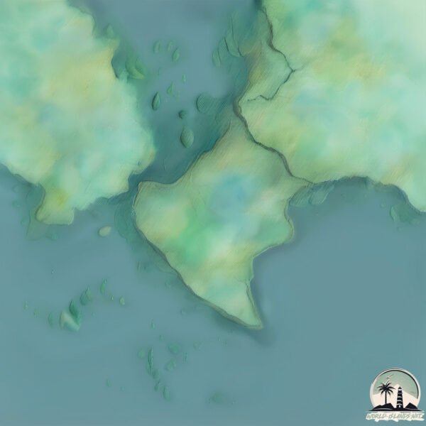
Welcome to Split Hill, a Tropical island in the Caribbean Sea, part of the majestic Atlantic Ocean. This guide offers a comprehensive overview of what makes Split Hill unique – from its geography and climate to its population, infrastructure, and beyond. Dive into the details:
Geography and size of Split Hill
Size: 3.55 km²
Coastline: 13.5 km
Ocean: Atlantic Ocean
Sea: Caribbean Sea
Continent: North America
Split Hill is a Small Island spanning 3.5 km² with a coastline of 13.5 km.
Archipel: –
Tectonic Plate: Panama – A small plate in Central America, primarily under Panama and Costa Rica, known for its seismic and volcanic activity due to interactions with the Cocos and Caribbean Plates.
The geographic heart of the island is pinpointed at these coordinates:
Latitude: 9.14661262 / Longitude: -82.1631627
Climate and weather of Split Hill
Climate Zone: Tropical
Climate Details: Tropical Rainforest Climate
Temperature: Hot
Climate Characteristics: This climate is typified by heavy rainfall throughout the year, high humidity, and consistently high temperatures, leading to lush rainforests and rich biodiversity. Seasonal temperature variations are minimal.
Topography and nature of Split Hill
Timezone: UTC-05:00
Timezone places: America/New_York
Max. Elevation: 38 m
Mean Elevation: 21 m
Vegetation: Evergreen Needleleaf Forest
Tree Coverage: 91%
The mean elevation is 21 m. The highest elevation on the island reaches approximately 38 meters above sea level. The island is characterized by Plains: Flat, low-lying lands characterized by a maximum elevation of up to 200 meters. On islands, plains are typically coastal lowlands or central flat areas.
Dominating Vegetation: Evergreen Needleleaf Forest
Dominated by evergreen coniferous trees such as pines and firs, which retain their needle-like leaves throughout the year. These forests are often found in cooler climates. Split Hill has a tree cover of 91 %.
Vegetation: 4 vegetation zones – Diverse Island
Four distinct vegetation zones mark these islands as ecologically diverse. They might feature varied landscapes such as forests, beaches, grasslands, and rocky areas. Such diversity reflects the island’s complex ecological interactions and varied habitats, which can support a rich array of wildlife and plant species.
Infrastructure and Travelling to Split Hill
Does the island have a public airport? no.
There is no public and scheduled airport on Split Hill. The nearest airport is Bocas del Toro International Airport, located 22 km away.
Does the island have a major port? no.
There are no major ports on Split Hill. The closest major port is BOCAS DEL TORO, approximately 21 km away.
The mean population of Split Hill is 32 per km². Split Hill is Gently Populated. The island belongs to Panama.
Continuing your journey, Popa is the next notable island, situated merely km away.
Split, Croatia Travel Guide 🇭🇷✨ 💾 Save this post for later! Planning a trip to Croatia? You
Split, Croatia Travel Guide ✨ Save this post for later! Planning a trip to Croatia? You have to add Split to your list.Split, Croatia Travel Guide 🇭🇷✨ 💾 Save this post for later! Planning a trip to Croatia? You
Split, Croatia Travel Guide ✨ Save this post for later! Planning a ...
Split, Croatia Travel Guide ✨ Save this post for later! Planning a trip to Croatia? You have to add Split to your list.
Top Things to Do in Split: Diocletian's Palace, Old Town, Riva Promenade, Marjan Hill #splitcroatia
Split Croatia | Split 3 Days Itinerary | Things to do in Split Croatia | Split Travel Guide
Welcome to The Travel Guardian! In this video, we explore one of the ...
Welcome to The Travel Guardian! In this video, we explore one of the most breathtaking destinations in the Adriatic—Split, Croatia ...
Split’s Hidden Gem 💎 #Croatia #split #hiddengems #travel #roadtrips #walks #hikes #outdoors
New Guide✨ Split's Hidden Gem: Marjan Hill If you're planning a visit ...
New Guide✨ Split's Hidden Gem: Marjan Hill If you're planning a visit to Split, add this little 2 mile walk to your list! It's only ...
View on Split and Dalmatian Islands from Kozjak hill
View from Debelić (710m) in Kaštela near Split (Croatia)
View from Debelić (710m) in Kaštela near Split (Croatia)
Split, Croatia: Modern City on Ancient Roots - Rick Steves’ Europe Travel Guide - Travel Bite
More info about travel to Split: ...
Hvar, Croatia has it all | Top places to visit #discovercroatia #hvar #croatialovers #adriaticsea
If you are planning travel to Europe, you must look out for this ...
If you are planning travel to Europe, you must look out for this amazing island in Croatia. You can reach Hvar by boat trip from ...
Must-Do’s in Split, Croatia 🇭🇷 👇🏻 check description #travel #croatia #vacation
Must-Do's in Split, Croatia save for later 1️⃣ Dive into History & ...
Must-Do's in Split, Croatia save for later 1️⃣ Dive into History & Game of Thrones: Explore Diocletian's Palace, ...
Split Croatia Travel Guide: Best Things to Do In 2026
Explore Top 5 Best Things To Do In Split Croatia Travel Guide! From ...
Explore Top 5 Best Things To Do In Split Croatia Travel Guide! From Diocletians Palace to Bacvice Beach to Marjan Hill to ...
Explore CROATIA’S Largest Port City. Top 5 Things to Do in Split #croatiatravel #splitcroatia
Marjan Park-Forest, Split-Croatia
Split Croatia, park Marjan.
Split Croatia, park Marjan.
Guide to Split Croatia - Tour Diocletians Palace
Come with me on an ultimate guided tour of Split Croatia! I will take ...
Come with me on an ultimate guided tour of Split Croatia! I will take you with a local guide throughout the city, show you the best ...
Discover Split, Croatia: Top Things to Do! 🇭🇷✨ #VisitSplit #TravelGoals
Discover the enchanting beauty of Split, Croatia! Explore the ancient ...
Discover the enchanting beauty of Split, Croatia! Explore the ancient Diocletian's Palace, relax on stunning beaches, and savor ...
Bacvice Beach in Split, Croatia 🇭🇷
Split, Croatia. The ULTIMATE summer destination
split Croatia landing Take-off #beautiful #aviation #flying #airbus #a320 #amazing #cabincrew #split
10 things to do in Split, Croatia for an epic summer trip 🌊
shorts #travel #traveling #traveler #visit.
shorts #travel #traveling #traveler #visit.
📍 Split, Croatia - Take a dip in the turquoise waters, explore the nearby islands 😎 #travel
Living the life with @sailweek just outside of Split in Croatia. ...
Living the life with @sailweek just outside of Split in Croatia. Split, Croatia is the ultimate destination for adventure seekers, with ...
A Weekend in Split 🍹, Croatia
Bumble coffee (orange fresh and espresso), day trips to neighbouring ...
Bumble coffee (orange fresh and espresso), day trips to neighbouring towns and swimming in the sea. That's Split!
Just 2.44% of Dead Island 2 Players Have This Ultra Rare Achievement
Not a lot of gamers have the Donk! achievement from Dead Island 2, but ...
Not a lot of gamers have the Donk! achievement from Dead Island 2, but here's an easy guide on how to earn it FAST.
Top 5 places to Visit in Split, Croatia #shorts
Top 5 places to Visit in Split, Croatia #shorts.
Top 5 places to Visit in Split, Croatia #shorts.
Okay maybe not the ONLY 3! But if you only have a week, these are the 3 spots I recommend
Okay maybe not the ONLY 3! But if you only have a week, these are the ...
Okay maybe not the ONLY 3! But if you only have a week, these are the 3 spots I recommend prioritizing With one week off ...
Sightseeing Tour in SPLIT Marjan hill #travel #sightseeingtour #visitcroatia
Sightseeing Tour on Marjan hill by slow train. Marjan hill is located ...
Sightseeing Tour on Marjan hill by slow train. Marjan hill is located near town center (10 minutes walk from center). You can get ...
Jeremy Clarkson, Kaleb Cooper and Cheerful Charlie #splittheh | Hawkstone
Come split the h with us at The Farmer's Dog Pub or find a Hawkstone ...
Come split the h with us at The Farmer's Dog Pub or find a Hawkstone pub near you on our pub finder: ...
Exploring Diocletian’s Palace in Split, Croatia
Come with me to explore the ancient palace of Diocletian in Split, Croatia.
Come with me to explore the ancient palace of Diocletian in Split, Croatia.
Panama is classified as Developing region: Regions characterized by lower income levels, with economies in the process of industrialization and modernization. The level of income is Upper middle income.
News – Latest Updates and Headlines from Split Hill
Stay informed with the most recent news and important headlines from Split Hill. Here’s a roundup of the latest developments.
Loading...
Please note: The data used here has been primarily extracted from satellite readings. Deviations from exact values may occur, particularly regarding the height of elevations and population density. Land area and coastline measurements refer to average values at mean high tide.