St. George
Welcome to St. George, a Polar island in the North Pacific Ocean, part of the majestic Pacific Ocean. This guide offers a comprehensive overview of what makes St. George unique – from its geography and climate to its population, infrastructure, and beyond. Dive into the details:
- Geography and Size: Explore the island’s size and location.
- Climate and Weather: Weather patterns and temperature.
- Topography and Nature: Uncover the natural wonders of the island.
- Infrastructure and Travelling: Insights on reaching, staying, and making the most of your visit.
- News and Headlines: Latest News.
Geography and size of St. George
Size: 87.3 km²
Coastline: 69.1 km
Ocean: Pacific Ocean
Sea: North Pacific Ocean
Continent: North America
St. George is a Medium Island spanning 87 km² with a coastline of 69 km.
Archipel: –
Tectonic Plate: North America – Covers North America and parts of the Atlantic and Arctic Oceans, characterized by diverse geological features and varying levels of seismic activity.
The geographic heart of the island is pinpointed at these coordinates:
Latitude: 53.05481531 / Longitude: -158.50347434
Climate and weather of St. George
Climate Zone: Polar
Climate Details: Tundra
Temperature: Cold
Climate Characteristics: The tundra climate features long, extremely cold winters and short, cool summers. Vegetation is limited to mosses, lichens, and small shrubs due to the low temperatures and short growing seasons. Biodiversity is low, but some specialized species thrive.
Topography and nature of St. George
Timezone: UTC-09:00
Timezone places: America/Anchorage
Max. Elevation: 260 m
Mean Elevation: 124 m
Vegetation: Herbaceous Cover
Tree Coverage: 25%
The mean elevation is 124 m. The highest elevation on the island reaches approximately 260 meters above sea level. The island is characterized by Hills: Gently sloping landforms with rounded tops, having a maximum elevation between 200 and 500 meters. Hills contribute to a varied landscape on islands.
Dominating Vegetation: Herbaceous Cover
Comprising mainly of grasses, herbs, and ferns, these areas are common in prairies, meadows, and savannas, and can vary widely in species composition. St. George has a tree cover of 25 %.
Vegetation: 11 vegetation zones – Exceptionally Diverse Island
Islands with more than ten vegetation zones are among the most ecologically rich and varied in the world. These islands are akin to miniature continents, boasting an incredible array of ecosystems. The sheer range of habitats, from high peaks to deep valleys, rainforests to deserts, creates a mosaic of life that is unparalleled. They are crucial for conservation and ecological studies.
Infrastructure and Travelling to St. George
Does the island have a public airport? yes.
St. George has a public and scheduled airport. The following airports are located on this island: St George Airport.
Does the island have a major port? no.
There are no major ports on St. George. The closest major port is CARRABELLE, approximately 9 km away.
The mean population of St. George is 6 per km². St. George is Gently Populated. The island belongs to United States of America.
The name of the island resonates across different cultures and languages. Here is how it is known around the world: Arabic: جزر بريبيلوف; German: Pribilof Islands; Spanish: Islas Pribilof; French: îles Pribilof; Portuguese: Ilhas Pribilof; Russian: Острова Прибылова; Chinese: 普里比洛夫群岛
Continuing your journey, St. Vincent is the next notable island, situated merely km away.
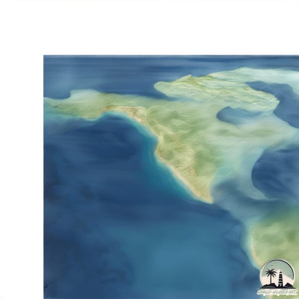
Aerial views of St. George Island #SaltyFlorida


United States of America is classified as Developed region: G7: Group of Seven – Major advanced economies, including Canada, France, Germany, Italy, Japan, the United Kingdom, and the United States. The level of income is High income: OECD.
News – Latest Updates and Headlines from St. George
Stay informed with the most recent news and important headlines from St. George. Here’s a roundup of the latest developments.
Please note: The data used here has been primarily extracted from satellite readings. Deviations from exact values may occur, particularly regarding the height of elevations and population density. Land area and coastline measurements refer to average values at mean high tide.