Welcome to St. Helena, a Temperate island in the Coral Sea, part of the majestic Pacific Ocean. This guide offers a comprehensive overview of what makes St. Helena unique – from its geography and climate to its population, infrastructure, and beyond. Dive into the details:
Geography and size of St. Helena
Size: 1.934 km²
Coastline: 6.7 km
Ocean: Pacific Ocean
Sea: Coral Sea
Continent: Oceania
St. Helena is a Small Island spanning 1.9 km² with a coastline of 6.7 km.
Archipel: –
Tectonic Plate: Australia – A major tectonic plate covering Australia, New Zealand, and parts of the Indian and Pacific Oceans, known for its relative stability and occasional seismic activity.
The geographic heart of the island is pinpointed at these coordinates:
Latitude: -27.38853939 / Longitude: 153.23488893
Climate and weather of St. Helena
Climate Zone: Temperate
Climate Details: Humid Subtropical Climate
Temperature: Hot Summer
Climate Characteristics: With continuous rainfall and hot summers, this climate is common in some coastal regions, supporting diverse vegetation.
Topography and nature of St. Helena
Timezone: UTC+10:00
Timezone places: Australia/Sydney
Max. Elevation: 4 m
Mean Elevation: 2 m
Vegetation: Evergreen Needleleaf Forest
Tree Coverage: 34%
The mean elevation is 2 m. The highest elevation on the island reaches approximately 4 meters above sea level. The island is characterized by Plains: Flat, low-lying lands characterized by a maximum elevation of up to 200 meters. On islands, plains are typically coastal lowlands or central flat areas.
Dominating Vegetation: Evergreen Needleleaf Forest
Dominated by evergreen coniferous trees such as pines and firs, which retain their needle-like leaves throughout the year. These forests are often found in cooler climates. St. Helena has a tree cover of 34 %.
Vegetation: 5 vegetation zones – Highly Diverse Island
With five different vegetation zones, these islands offer a rich tapestry of ecosystems. The variety could include dense forests, open meadows, wetlands, coastal zones, and more. This level of diversity supports an intricate web of life, with each zone playing a vital role in the overall ecological health and balance of the island.
Infrastructure and Travelling to St. Helena
Does the island have a public airport? no.
There is no public and scheduled airport on St. Helena. The nearest airport is Brisbane International Airport, located 12 km away.
Does the island have a major port? no.
There are no major ports on St. Helena. The closest major port is BRISBANE, approximately 23 km away.
The mean population of St. Helena is 0 per km². St. Helena is Uninhabited. The island belongs to Australia.
Continuing your journey, North Stradbroke is the next notable island, situated merely km away.
The City of Jamestown St Helena - to Live, Work & Explore
Jamestown is the capital of St Helena Island, a British Overseas Territory in the South Atlantic Ocean. Until recently St Helena was ...The City of Jamestown St Helena - to Live, Work & Explore
Jamestown is the capital of St Helena Island, a British Overseas ...
Jamestown is the capital of St Helena Island, a British Overseas Territory in the South Atlantic Ocean. Until recently St Helena was ...
St. Helena - A remote island in the Atlantic | DW Documentary
Every third week, a British Royal Mail ship begins its journey from ...
Every third week, a British Royal Mail ship begins its journey from Cape Town to Saint Helena, the remote island in the Atlantic ...
Saint Helena Island Travel Guide: 16 BEST Things To Do In Saint Helena Island
This Saint Helena Island travel guide shares the best things to do in ...
This Saint Helena Island travel guide shares the best things to do in Saint Helena Island. -------------- How to travel more and visit ...
Family Life on St Helena Island
St Helena is the perfect place to connect with nature. The tranquility ...
St Helena is the perfect place to connect with nature. The tranquility of the island provides a digital detox from the hustle and ...
Saint Helena: Breathtaking nature in one of the most remote places on earth | DW Documentary
The small island of St. Helena in the South Atlantic is home to unique ...
The small island of St. Helena in the South Atlantic is home to unique fauna and flora. Many of the more than 400 species living ...
INJURED AT SEA - LANDFALL at REMOTE ST HELENA ISLAND after 11 DAYS AT SEA
INJURED AT SEA - LANDFALL at REMOTE ST HELENA ISLAND after 11 DAYS AT ...
INJURED AT SEA - LANDFALL at REMOTE ST HELENA ISLAND after 11 DAYS AT SEA After 11 days and over 1200 nautical ...
St Helena Island - Ep. 24
The last home of Napolean and the current home of Jonathan the oldest ...
The last home of Napolean and the current home of Jonathan the oldest living thing on earth! This special place isn't easy to get to ...
Saint Helena Island - A remote beauty!
Join us on an unforgettable journey to the remote and enchanting ...
Join us on an unforgettable journey to the remote and enchanting island of Saint Helena, nestled in the vastness of the South ...
Travel fact - Saint Helena Island
The island belongs to the British Empire as part of the overseas ...
The island belongs to the British Empire as part of the overseas territory, but with its part. Official name: Islands of St. Helena, ...
What To Do in St Helena
This trip to the St. Helena took place from 15 - 18 February 2020, ...
This trip to the St. Helena took place from 15 - 18 February 2020, before the major current travel restrictions. I do not encourage ...
Where to stay on St Helena Island - Holiday Accommodation for Visitors
St Helena Island offers visitors a range of hotels, B&Bs and ...
St Helena Island offers visitors a range of hotels, B&Bs and self-catering properties in Jamestown, and also up in the countryside ...
Living off-grid on a Remote Island
Discover the Beauty and Simplicity of Off-Grid Living on St Helena ...
Discover the Beauty and Simplicity of Off-Grid Living on St Helena Join us on a journey to the remote island of St Helena, ...
Landing St Helena - Airlink Embraer 190 - Windshear
Landing and Take-Off from St Helena, British Overseas Territory in the ...
Landing and Take-Off from St Helena, British Overseas Territory in the South Atlantic Ocean. The short runway built on a cliff of the ...
The Island Where Napoleon Was Sent to Die
They needed a prison for the most dangerous man in the World. Napoleon ...
They needed a prison for the most dangerous man in the World. Napoleon had seized supreme power in France. He'd marched ...
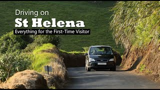
Driving on St Helena - Everything for the First-Time Visitor
Driving on St Helena is probably the best way to experience the ...
Driving on St Helena is probably the best way to experience the island, whether you're a resident or short-term visitor. Although St ...
St Helena Island - How we spent 7 magnificent days in the South Atlantic!
We had one week on this little island and wanted to explore as much as ...
We had one week on this little island and wanted to explore as much as possible. Our accommodation on Wrangham's Coffee ...
Invest In St Helena
Our British Overseas Territory is a breath of fresh air in today's ...
Our British Overseas Territory is a breath of fresh air in today's world, boasting clean air, a pristine ocean environment, a small and ...
St Helena Island, a world within a world apart
St Helena Island: A history treasure trove. Walk in the footsteps of ...
St Helena Island: A history treasure trove. Walk in the footsteps of Napoleon, the Duke of Wellington, Edmund Halley, Charles ...
Ep 46: Saint Helena - A fascinating Island
I'm staying for 12 days on this remote island in the South Atlantic ...
I'm staying for 12 days on this remote island in the South Atlantic before sailing on to Cape Town. I'm exploring the island and ...
Discovering Napoleon's Island: Saint Helena Awaits!
Join us as we explore the fascinating history and beauty of Saint ...
Join us as we explore the fascinating history and beauty of Saint Helena, the island where Napoleon was exiled. #shorts ...
Flying to St Helena Airport
This trip to the St. Helena Airport took place on 15 February 2020, ...
This trip to the St. Helena Airport took place on 15 February 2020, before the major current travel restrictions. Here's a video with ...
12 Great Reasons to Visit St Helena Island
Twelve, 90-second films of St Helena, produced originally as 'Show ...
Twelve, 90-second films of St Helena, produced originally as 'Show Reels' for the 2022 Miss St Helena pageant, with each ...
Investment Properties | St Helena Island
Flight deck to the most remote Atlantic island
Today we're flying in the cockpit to one of the most remote airports ...
Today we're flying in the cockpit to one of the most remote airports in the world: onboard Airlink from Johannesburg to St. Helena, ...
St Helena - A Breath of Fresh Air
St Helena is so special to the people that live here, both locals and ...
St Helena is so special to the people that live here, both locals and those who have travelled the distance to now call St Helena ...
Australia is classified as Developed region: nonG7: Developed economies outside of the Group of Seven, characterized by high income and advanced economic structures. The level of income is High income: OECD.
News – Latest Updates and Headlines from St. Helena
Stay informed with the most recent news and important headlines from St. Helena. Here’s a roundup of the latest developments.
Loading...
Please note: The data used here has been primarily extracted from satellite readings. Deviations from exact values may occur, particularly regarding the height of elevations and population density. Land area and coastline measurements refer to average values at mean high tide.