Stocking Island
Welcome to Stocking Island, a Tropical island in the North Atlantic Ocean, part of the majestic Atlantic Ocean. This guide offers a comprehensive overview of what makes Stocking Island unique – from its geography and climate to its population, infrastructure, and beyond. Dive into the details:
- Geography and Size: Explore the island’s size and location.
- Climate and Weather: Weather patterns and temperature.
- Topography and Nature: Uncover the natural wonders of the island.
- Infrastructure and Travelling: Insights on reaching, staying, and making the most of your visit.
- News and Headlines: Latest News.
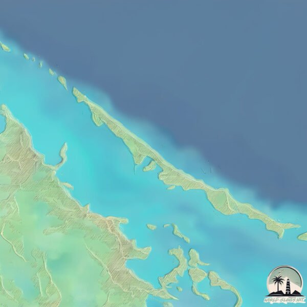
Geography and size of Stocking Island
Size: 2.304 km²
Coastline: 15.8 km
Ocean: Atlantic Ocean
Sea: North Atlantic Ocean
Continent: North America
Stocking Island is a Small Island spanning 2.3 km² with a coastline of 15.8 km.
Archipel: Bahama Islands – An archipelago in the Atlantic Ocean, known for their stunning beaches, coral reefs, and vibrant culture.
Tectonic Plate: North America – Covers North America and parts of the Atlantic and Arctic Oceans, characterized by diverse geological features and varying levels of seismic activity.
The geographic heart of the island is pinpointed at these coordinates:
Latitude: 23.524052 / Longitude: -75.75636518
Climate and weather of Stocking Island
Climate Zone: Tropical
Climate Details: Tropical Savanna, Wet
Temperature: Hot
Climate Characteristics: Defined by distinct wet and dry seasons with high temperatures year-round. Pronounced rainfall occurs during the wet season, while the dry season is marked by drought.
Topography and nature of Stocking Island
Timezone: UTC-05:00
Timezone places: America/New_York
Max. Elevation: 4 m
Mean Elevation: 3 m
Vegetation: Evergreen Broadleaf Forest
Tree Coverage: 85%
The mean elevation is 3 m. The highest elevation on the island reaches approximately 4 meters above sea level. The island is characterized by Plains: Flat, low-lying lands characterized by a maximum elevation of up to 200 meters. On islands, plains are typically coastal lowlands or central flat areas.
Dominating Vegetation: Evergreen Broadleaf Forest
Characterized by dense, lush canopies of broadleaf trees that retain their leaves year-round. These forests are typically found in tropical and subtropical regions and are known for their high biodiversity. Stocking Island has a tree cover of 85 %.
Vegetation: 3 vegetation zones – Moderately Diverse Island
These islands start to show a broader range of ecological niches. With three vegetation zones, they may offer a mix of ecosystems like coastal areas, inland woods, and perhaps a distinct wetland or dry area. This diversity supports a wider range of flora and fauna, making these islands more ecologically complex than those with minimal diversity.
Infrastructure and Travelling to Stocking Island
Does the island have a public airport? no.
There is no public and scheduled airport on Stocking Island. The nearest airport is Exuma International Airport, located 11 km away.
Does the island have a major port? no.
There are no major ports on Stocking Island. The closest major port is COCKBURN TOWN, approximately 146 km away.
The mean population of Stocking Island is 35 per km². Stocking Island is Gently Populated. The island belongs to The Bahamas.
Continuing your journey, Great Exuma is the next notable island, situated merely km away.
The Bahamas is classified as Developing region: Regions characterized by lower income levels, with economies in the process of industrialization and modernization. The level of income is High income: nonOECD.
News – Latest Updates and Headlines from Stocking Island
Stay informed with the most recent news and important headlines from Stocking Island. Here’s a roundup of the latest developments.
- This Collection of 365 Islands in The Bahamas Has Swimming Pigs, Private Island Resorts, and Pristine Beaches - Travel + Leisureby "Great Exuma island" - Google News on 3 March 2026
This Collection of 365 Islands in The Bahamas Has Swimming Pigs, Private Island Resorts, and Pristine Beaches Travel + Leisure
- From Fyre Fest failure to secret billionaire escape, can this sun-soaked island chain challenge the Maldives? - New York Postby "Great Exuma island" - Google News on 27 February 2026
From Fyre Fest failure to secret billionaire escape, can this sun-soaked island chain challenge the Maldives? New York Post
- These Bahamian Islands Are Home to a Rare, Pink Species of Lizard Found Nowhere Else on Earth—Here’s How to Visit - Travel + Leisureby "Great Exuma island" - Google News on 26 February 2026
These Bahamian Islands Are Home to a Rare, Pink Species of Lizard Found Nowhere Else on Earth—Here’s How to Visit Travel + Leisure
- The ‘Crown Jewel’ of the Bahamas’ Exuma Cays is For Sale, Starting at $125 Million - Mansion Globalby "Great Exuma island" - Google News on 19 February 2026
The ‘Crown Jewel’ of the Bahamas’ Exuma Cays is For Sale, Starting at $125 Million Mansion Global
- Illegally stocked yellow perch discovered in Island Park Reservoir - NBC Montanaby "Stocking Island island" - Google News on 13 January 2026
Illegally stocked yellow perch discovered in Island Park Reservoir NBC Montana
- Robbie Williams moves to Caribbean island paradise after banking HUGE sum buying & selling property - The Sunby "Stocking Island island" - Google News on 13 January 2026
Robbie Williams moves to Caribbean island paradise after banking HUGE sum buying & selling property The Sun
- Illegally stocked yellow perch caught in Island Park Reservoir - KTVBby "Stocking Island island" - Google News on 12 January 2026
Illegally stocked yellow perch caught in Island Park Reservoir KTVB
- Stockings, scenery and a final farewell to island life from Wren - Isle of Man Todayby "Stocking Island island" - Google News on 11 January 2026
Stockings, scenery and a final farewell to island life from Wren Isle of Man Today
- Nassau Unites with Exuma, Harbour Island, Eleuthera and more for an Unmatched Christmas and New Year in the Bahamas – Make 2025 Your Most Memorable Holiday Yet! - Travel And Tour Worldby "Stocking Island island" - Google News on 7 December 2025
Nassau Unites with Exuma, Harbour Island, Eleuthera and more for an Unmatched Christmas and New Year in the Bahamas – Make 2025 Your Most Memorable Holiday Yet! Travel And Tour World
- Rosewood Exuma opponent in legal challenge go-ahead - Tribune242by "Great Exuma island" - Google News on 4 December 2025
Rosewood Exuma opponent in legal challenge go-ahead Tribune242
Please note: The data used here has been primarily extracted from satellite readings. Deviations from exact values may occur, particularly regarding the height of elevations and population density. Land area and coastline measurements refer to average values at mean high tide.