Strangers Cay
Welcome to Strangers Cay, a Tropical island in the North Atlantic Ocean, part of the majestic Atlantic Ocean. This guide offers a comprehensive overview of what makes Strangers Cay unique – from its geography and climate to its population, infrastructure, and beyond. Dive into the details:
- Geography and Size: Explore the island’s size and location.
- Climate and Weather: Weather patterns and temperature.
- Topography and Nature: Uncover the natural wonders of the island.
- Infrastructure and Travelling: Insights on reaching, staying, and making the most of your visit.
- News and Headlines: Latest News.
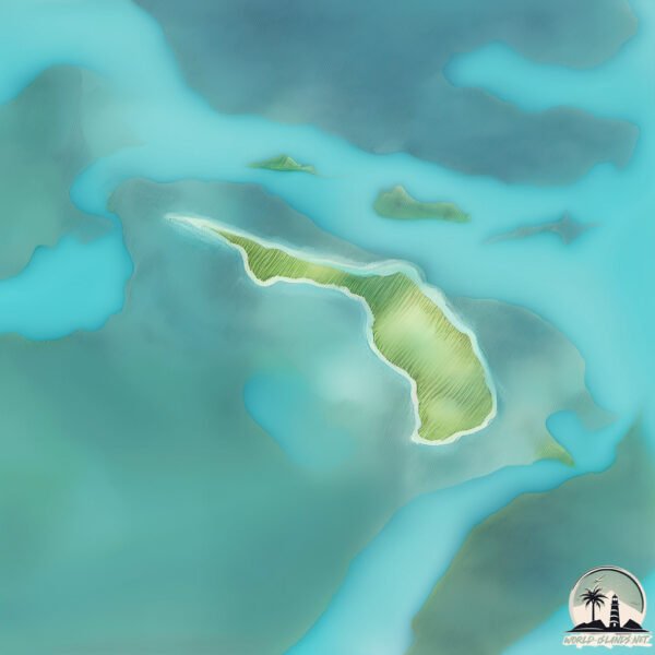
Geography and size of Strangers Cay
Size: 1.505 km²
Coastline: 7.9 km
Ocean: Atlantic Ocean
Sea: North Atlantic Ocean
Continent: North America
Strangers Cay is a Small Island spanning 1.5 km² with a coastline of 7.9 km.
Archipel: Bahama Islands – An archipelago in the Atlantic Ocean, known for their stunning beaches, coral reefs, and vibrant culture.
Tectonic Plate: North America – Covers North America and parts of the Atlantic and Arctic Oceans, characterized by diverse geological features and varying levels of seismic activity.
The geographic heart of the island is pinpointed at these coordinates:
Latitude: 27.12058675 / Longitude: -78.08578027
Climate and weather of Strangers Cay
Climate Zone: Tropical
Climate Details: Tropical Monsoon Climate
Temperature: Hot
Climate Characteristics: Characterized by heavy rainfall, high humidity, and uniformly high temperatures, but with a distinct short dry season. It features a seasonal reversal of prevailing wind directions.
Topography and nature of Strangers Cay
Timezone: UTC-05:00
Timezone places: America/New_York
Max. Elevation: 2 m
Mean Elevation: 1 m
Vegetation: Shrubland
Tree Coverage: 58%
The mean elevation is 1 m. The highest elevation on the island reaches approximately 2 meters above sea level. The island is characterized by Plains: Flat, low-lying lands characterized by a maximum elevation of up to 200 meters. On islands, plains are typically coastal lowlands or central flat areas.
Dominating Vegetation: Shrubland
Dominated by shrubs and small bushes, these areas are typical in dry, rocky, or sandy environments, as well as in regions with poor soil fertility. Strangers Cay has a tree cover of 58 %.
Vegetation: 4 vegetation zones – Diverse Island
Four distinct vegetation zones mark these islands as ecologically diverse. They might feature varied landscapes such as forests, beaches, grasslands, and rocky areas. Such diversity reflects the island’s complex ecological interactions and varied habitats, which can support a rich array of wildlife and plant species.
Infrastructure and Travelling to Strangers Cay
Does the island have a public airport? no.
There is no public and scheduled airport on Strangers Cay. The nearest airport is Treasure Cay Airport, located 86 km away.
Does the island have a major port? no.
There are no major ports on Strangers Cay. The closest major port is SOUTH RIDING POINT, approximately 57 km away.
The mean population of Strangers Cay is 48 per km². Strangers Cay is Gently Populated. The island belongs to The Bahamas.
Continuing your journey, Lightbourn’s Cay is the next notable island, situated merely km away.
Strangers Cay part 1


The Bahamas is classified as Developing region: Regions characterized by lower income levels, with economies in the process of industrialization and modernization. The level of income is High income: nonOECD.
News – Latest Updates and Headlines from Strangers Cay
Stay informed with the most recent news and important headlines from Strangers Cay. Here’s a roundup of the latest developments.
Please note: The data used here has been primarily extracted from satellite readings. Deviations from exact values may occur, particularly regarding the height of elevations and population density. Land area and coastline measurements refer to average values at mean high tide.