Welcome to Stromness, a Continental island in the Hudson Bay, part of the majestic Arctic Ocean. This guide offers a comprehensive overview of what makes Stromness unique – from its geography and climate to its population, infrastructure, and beyond. Dive into the details:
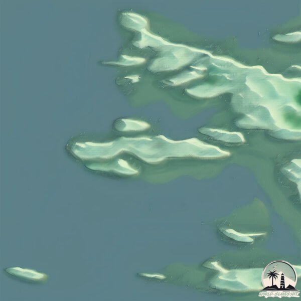
Geography and size of Stromness
Size: 2.01 km²
Coastline: 9.6 km
Ocean: Arctic Ocean
Sea: Hudson Bay
Continent: North America
Stromness is a Small Island spanning 2 km² with a coastline of 9.6 km.
Archipel: –
Tectonic Plate: North America – Covers North America and parts of the Atlantic and Arctic Oceans, characterized by diverse geological features and varying levels of seismic activity.
The geographic heart of the island is pinpointed at these coordinates:
Latitude: 53.87254892 / Longitude: -79.12783395
Climate and weather of Stromness
Climate Zone: Continental
Climate Details: Dry-Summer Subarctic Climate
Temperature: Cold Summer
Climate Characteristics: Short, mild summers with significantly less moisture, and prolonged cold periods. Found in northern, inland regions.
Topography and nature of Stromness
Timezone: UTC-05:00
Timezone places: America/New_York
Max. Elevation: 2 m
Mean Elevation: -3 m
Vegetation: Herbaceous Cover
Tree Coverage: 39%
The mean elevation is -3 m. The highest elevation on the island reaches approximately 2 meters above sea level. The island is characterized by Plains: Flat, low-lying lands characterized by a maximum elevation of up to 200 meters. On islands, plains are typically coastal lowlands or central flat areas.
Dominating Vegetation: Herbaceous Cover
Comprising mainly of grasses, herbs, and ferns, these areas are common in prairies, meadows, and savannas, and can vary widely in species composition. Stromness has a tree cover of 39 %.
Vegetation: 4 vegetation zones – Diverse Island
Four distinct vegetation zones mark these islands as ecologically diverse. They might feature varied landscapes such as forests, beaches, grasslands, and rocky areas. Such diversity reflects the island’s complex ecological interactions and varied habitats, which can support a rich array of wildlife and plant species.
Infrastructure and Travelling to Stromness
Does the island have a public airport? no.
There is no public and scheduled airport on Stromness. The nearest airport is Chisasibi Airport, located 22 km away.
Does the island have a major port? no.
There are no major ports on Stromness. The closest major port is KEY HARBOUR, approximately 905 km away.
The mean population of Stromness is 0 per km². Stromness is Uninhabited. The island belongs to Canada.
Continuing your journey, North Twin Island is the next notable island, situated merely km away.
Slow Orkney - Stromness
Join us on the streets and shoreline of Stromness for our latest 'Slow Orkney' feature. We know that you can't visit us here in ...Slow Orkney - Stromness
Join us on the streets and shoreline of Stromness for our latest 'Slow ...
Join us on the streets and shoreline of Stromness for our latest 'Slow Orkney' feature. We know that you can't visit us here in ...
The Islands With Too Much Power
The Orkney Islands, off the northern tip of Scotland, have so much ...
The Orkney Islands, off the northern tip of Scotland, have so much electricity that it's actually a problem. Here's why: and here's ...
Tom Knight, John Dunn and JSM told us to go to Orkney, so we did! Viewers' Choice Episode One 🙂
We had a few days off together and put out the question on the YouTube ...
We had a few days off together and put out the question on the YouTube Community page for ideas of where to go and boy did ...
Driving down Main Street in Stromness, Orkney Islands
Recorded August 2017 Please consider subscribing ! ...
Stromness - The South Georgia Whaling Station Initiative (4K Drone Footage) – Red Viking Productions
The Whaling stations on South Georgia Island are rich with history and ...
The Whaling stations on South Georgia Island are rich with history and heritage. In 1916, Sir Earnest Shackleton reached ...
Orkney Islands Adventure: Battling the Elements in Stromness, Scotland
Join us on an unforgettable adventure through the wild and windy ...
Join us on an unforgettable adventure through the wild and windy Orkney Islands in Scotland. As we explore the charming coastal ...
Travelling The Orkney Islands For 7 Days
Travelling the Orkney Islands for 7 days. Lying off the north coast of ...
Travelling the Orkney Islands for 7 days. Lying off the north coast of Scotland, Orkney is an archipelago of around 70 islands.
Orkney Islands | Scotland (film + guide)
ORKNEY MAINLAND TRAVEL GUIDE ...
A guide to sailing Stromness | Sail Scotland
Discover why you should pay a visit to Stromness Marina on Orkney on ...
Discover why you should pay a visit to Stromness Marina on Orkney on your next adventure sailing Scotland! An ideal marina for ...
Fishing boats Stromness Orkney islands Scotland 10 Oct 2023
Orkney's Island Adventures highlights
Visit Orkney and explore our islands for all seasons. Experience over ...
Visit Orkney and explore our islands for all seasons. Experience over 70 different islands, their unique heritage and fascinating ...
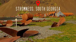
Stromness, South Georgia 4K
Stromness is an abandoned whaling station on the northern coast of ...
Stromness is an abandoned whaling station on the northern coast of South Georgia Island in the South Atlantic. It was the ...
How Busy Does KIRKWALL Get When The Cruise Ships Arrive? Join Me For A Wander Round Orkney's Capital
I happened to be in Kirkwall, Orkney when one of the big cruise ships ...
I happened to be in Kirkwall, Orkney when one of the big cruise ships arrived in port, so took the opportunity to compare what the ...
This is Orkney, Scotland! #scotland #scotlandtravelguide #explorescotland
Have you been to the Orkney Islands? ♀️ If not, then WHY NOT?? ...
Have you been to the Orkney Islands? ♀️ If not, then WHY NOT?? Journey back in time to some of the most ...
SCOTLAND'S most UNDERRATED Island (can't believe this is real)
After 3 days exploring one of Scotland's most Northern Isles, we can't ...
After 3 days exploring one of Scotland's most Northern Isles, we can't help but wonder why more people aren't talking about ...
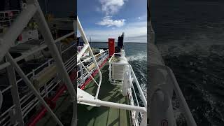
On the Ferry - Hoy to Stromness, Orkney Islands, Scotland.
Check out my Book: "INTO THE UNKNOWN - True Stories of a Pilot ...
Check out my Book: "INTO THE UNKNOWN - True Stories of a Pilot Cheating Death" on Amazon for $12.95 USD ...
Catch a Ferry to Orkney! - Northlink Ferries (outbound) and Pentland Ferries (inbound) #visitorkney
This film takes you on Northlink's Hamnavoe ferry from Scrabster to ...
This film takes you on Northlink's Hamnavoe ferry from Scrabster to Stromness, returning on Pentland Ferries' MV Alfred from St ...
Orkney Ferries, ferry MV Graemsay to island of Hoy, Stromness to Linksness
MV Graemsay is a small passenger ferry operated by Orkney Ferries. MV ...
MV Graemsay is a small passenger ferry operated by Orkney Ferries. MV Graemsay was built by Ailsa Shipbuilding Company, ...
Scrabster- Stromness (orkney island)
Traversata in traghetto. Davanti a noi si vedono le isole orcadi e in ...
Traversata in traghetto. Davanti a noi si vedono le isole orcadi e in particolare l'isola di HOY.
Shetland and Orkney Islands by Ferry: A Journey from Lerwick to Kirkwall and Stromness
Join us as we travel from the Shetland Islands to the Orkney Islands ...
Join us as we travel from the Shetland Islands to the Orkney Islands by ferry and explore the charming town of Kirkwall and the ...
The ferry from Scrabster, Scotland to Stromness Orkney you pass by the island of Hoy.
Farewell To Stromness by Peter Maxwell Davies
Peaceful and relaxing piano music accompanied by stunning HD images of ...
Peaceful and relaxing piano music accompanied by stunning HD images of Stromness. Piano performance by Peter Fagerlind.
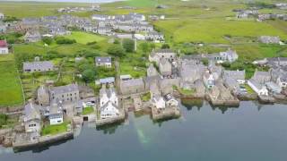
View of Stromness
A magnificent aerial view of Stromness in the Orkney Islands taken ...
A magnificent aerial view of Stromness in the Orkney Islands taken from over the bay.
Scotland’s Orkney Islands: Must-See Sites & Road Trip Highlights
Planning a trip to Scotland's Orkney Islands? This guide shows you the ...
Planning a trip to Scotland's Orkney Islands? This guide shows you the top things to do, historic sites, and must-see highlights ...
Scotland Orkney Islands Day Trip | 24 hours exploring Scotlands northern islands
Explore the Orkney Islands in just one day! In this travel guide, I ...
Explore the Orkney Islands in just one day! In this travel guide, I take you across one of Scotland's most fascinating island chains ...
Canada is classified as Developed region: G7: Group of Seven – Major advanced economies, including Canada, France, Germany, Italy, Japan, the United Kingdom, and the United States. The level of income is High income: OECD.
News – Latest Updates and Headlines from Stromness
Stay informed with the most recent news and important headlines from Stromness. Here’s a roundup of the latest developments.
Loading...
Please note: The data used here has been primarily extracted from satellite readings. Deviations from exact values may occur, particularly regarding the height of elevations and population density. Land area and coastline measurements refer to average values at mean high tide.