Welcome to Strong Island, a Continental island in the Labrador Sea, part of the majestic Atlantic Ocean. This guide offers a comprehensive overview of what makes Strong Island unique – from its geography and climate to its population, infrastructure, and beyond. Dive into the details:
Geography and size of Strong Island
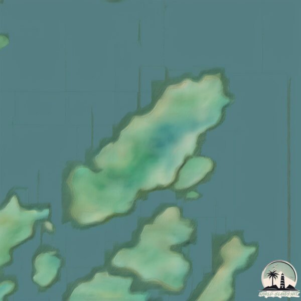
Size: 2.349 km²
Coastline: 8.9 km
Ocean: Atlantic Ocean
Sea: Labrador Sea
Continent: North America
Strong Island is a Small Island spanning 2.3 km² with a coastline of 8.9 km.
Archipel: –
Tectonic Plate: North America – Covers North America and parts of the Atlantic and Arctic Oceans, characterized by diverse geological features and varying levels of seismic activity.
The geographic heart of the island is pinpointed at these coordinates:
Latitude: 49.41934555 / Longitude: -55.31959608
Climate and weather of Strong Island
Climate Zone: Continental
Climate Details: Warm-Summer Humid Continental Climate
Temperature: Warm Summer
Climate Characteristics: Features warm summers and cold winters with consistent precipitation, common in higher latitudes.
Topography and nature of Strong Island
Timezone: UTC-03:30
Timezone places: America/St_Johns
Max. Elevation: 45 m
Mean Elevation: 30 m
Vegetation: Mixed Forest
Tree Coverage: 55%
The mean elevation is 30 m. The highest elevation on the island reaches approximately 45 meters above sea level. The island is characterized by Plains: Flat, low-lying lands characterized by a maximum elevation of up to 200 meters. On islands, plains are typically coastal lowlands or central flat areas.
Dominating Vegetation: Mixed Forest
A combination of both deciduous and evergreen trees, often found in transitional zones between forest types. These forests offer a diverse habitat for various wildlife species. Strong Island has a tree cover of 55 %.
Vegetation: 3 vegetation zones – Moderately Diverse Island
These islands start to show a broader range of ecological niches. With three vegetation zones, they may offer a mix of ecosystems like coastal areas, inland woods, and perhaps a distinct wetland or dry area. This diversity supports a wider range of flora and fauna, making these islands more ecologically complex than those with minimal diversity.
Infrastructure and Travelling to Strong Island
Does the island have a public airport? no.
There is no public and scheduled airport on Strong Island. The nearest airport is Gander International Airport / CFB Gander, located 98 km away.
Does the island have a major port? no.
There are no major ports on Strong Island. The closest major port is CLARENVILLE, approximately 207 km away.
The mean population of Strong Island is 0 per km². Strong Island is Uninhabited. The island belongs to Canada.
Continuing your journey, Thwart Island is the next notable island, situated merely km away.
J.V.C. Force - Strong Island [HQ] (Original 12'' Version)
J.V.C. Force - Strong Island.J.V.C. Force - Strong Island [HQ] (Original 12'' Version)
J.V.C. Force - Strong Island.
J.V.C. Force - Strong Island.
Strong Island | Full Feature | Netflix
The forces of family, grief and racial injustice converge in this ...
The forces of family, grief and racial injustice converge in this Oscar-nominated documentary exploring the murder of filmmaker ...
Strong Island
Provided to YouTube by Universal Music Group Strong Island · Rakim The ...
Provided to YouTube by Universal Music Group Strong Island · Rakim The Master ℗ 1999 Universal Motown Records, a division ...
Strong Island | Official Trailer [HD] | Netflix
"The police had turned my brother into the prime suspect in his own ...
"The police had turned my brother into the prime suspect in his own murder." Filmmaker Yance Ford takes an emotional and ...
where the term Strong Island came from @Indastreetstv @TheOfficialJVCFORCE
Talking to Wildman Steve at Long Island Music & Entertainment Hall Of ...
Talking to Wildman Steve at Long Island Music & Entertainment Hall Of Fame June 2023 about the original of the term Strong ...
Strong Island Bootboys Scared Of No One
STRONG ISLAND FIGHT NIGHT SERIES 10
WE APOLOGIZE FOR THE QUALITY OF THIS PRODUCTION AND THE HORRIBLE ...
WE APOLOGIZE FOR THE QUALITY OF THIS PRODUCTION AND THE HORRIBLE AUDIO, THIS IS NOT WHAT OUR EVENTS ...
STRONG ISLAND Trailer - Yance Ford's Sundance Award-Winning Documentary
Watch FREE FULL MOVIES in exclusive
https://bit.ly/3woTiHZ Strong Island | Official Trailer [HD] | Netflix: Filmmaker Yance ...
The iLLiance - STRONG ISLAND (OFFICIAL MUSIC VIDEO)
The iLLiance music video for the song "Strong Island" Music Videos ...
Strong Island
Provided to YouTube by The Orchard Enterprises Strong Island · JVC ...
Provided to YouTube by The Orchard Enterprises Strong Island · JVC Force B-Boy Records: The Masterworks ℗ 1988 B-Boy ...
Talking about Strong Island Hip-Hop on T Money Podcast Joint
JVC Force - Strong Island (Redux with HQ Sound)
I grabbed djtruth's video of this song and re-duxed it a little to fit ...
I grabbed djtruth's video of this song and re-duxed it a little to fit the full length, full quality version of this classic track.
Strong Island | Clip: Intimidation | Netflix
"The police had turned my brother into the prime suspect in his own ...
"The police had turned my brother into the prime suspect in his own murder." Filmmaker Yance Ford takes an emotional and ...
Sugar Bear feat Tr3,Will & Dinco D ( Strong Island Still Prod By Bill Biggz) Official Music Video
Sugar Bear Releases New Video For His New Single Strong Island Still. ...
Sugar Bear Releases New Video For His New Single Strong Island Still. Sugar Bear, Dinco D John TR3 Pritchett & Will Are All ...
Strong Island (Vocal)
Provided to YouTube by The Orchard Enterprises Strong Island (Vocal) · ...
Provided to YouTube by The Orchard Enterprises Strong Island (Vocal) · JVC Force B-Boy Records: The Masterworks ℗ 1988 ...
Strong Island - Kids Inc. - Uncensored
Mark and Danny Petrelli help their neighbor Gino with a bully. The ...
Mark and Danny Petrelli help their neighbor Gino with a bully. The Comedy Central app has full episodes of your favorite shows ...
STRONG ISLAND FIGHT NIGHT SERIES: VOL 9
My Block: Strong Island Part 2 (Full Movie)
A story told by the African Americans who forged their own community ...
A story told by the African Americans who forged their own community featuring testimonies from WWII veterans, NBA Hall of ...
Strong Island FC 2012 Black 1-24-26 1st Half
"Strong Island" by You Blew It!
Strong Island
Provided to YouTube by Cygnus Music Ltd Strong Island · SR 'Amen'ded ...
Provided to YouTube by Cygnus Music Ltd Strong Island · SR 'Amen'ded Breaks ℗ 2017 Enter the Jungle Records Released on: ...
Rakim - Strong Island
Song Information Artist: Rakim Album: The Master Released: November ...
Song Information Artist: Rakim Album: The Master Released: November 30, 1999 Recorded: 1998–1999 Genre: Hip-Hop Label: ...
Strong Island
Provided to YouTube by IIP-DDS Strong Island · Toro Jones · Steve ...
Provided to YouTube by IIP-DDS Strong Island · Toro Jones · Steve Laudicina Toro Jones ℗ Steve Laudicina Released on: ...
Strong Island Boot Boys - Pitbull Breed(Full EP - Released 2012)
Oiband from New York(USA) Tracklist: A1 S.I.B.B. Stomp A2 Scared Of ...
Oiband from New York(USA) Tracklist: A1 S.I.B.B. Stomp A2 Scared Of None A3 Guilty B1 United Skins B2 Pitbull Breed.
Strong Island Entertainment
Canada is classified as Developed region: G7: Group of Seven – Major advanced economies, including Canada, France, Germany, Italy, Japan, the United Kingdom, and the United States. The level of income is High income: OECD.
News – Latest Updates and Headlines from Strong Island
Stay informed with the most recent news and important headlines from Strong Island. Here’s a roundup of the latest developments.
Loading...
Please note: The data used here has been primarily extracted from satellite readings. Deviations from exact values may occur, particularly regarding the height of elevations and population density. Land area and coastline measurements refer to average values at mean high tide.
![J.V.C. Force - Strong Island [HQ] (Original 12'' Version)](https://i.ytimg.com/vi/05pcczvmrjc/mqdefault.jpg)


![Strong Island | Official Trailer [HD] | Netflix](https://i.ytimg.com/vi/h64qugj_iDg/mqdefault.jpg)