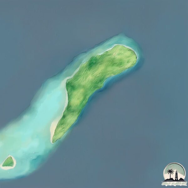
Welcome to Suf, a Tropical island in the South Pacific Ocean, part of the majestic Pacific Ocean. This guide offers a comprehensive overview of what makes Suf unique – from its geography and climate to its population, infrastructure, and beyond. Dive into the details:
Geography and size of Suf
Size: 2.868 km²
Coastline: 9.4 km
Ocean: Pacific Ocean
Sea: South Pacific Ocean
Continent: Oceania
Suf is a Small Island spanning 2.9 km² with a coastline of 9.4 km.
Archipel: Melanesia – A subregion of Oceania in the southwestern Pacific Ocean, including countries like Fiji, Solomon Islands, and Vanuatu, known for their diverse cultures and languages.
Tectonic Plate: Birds Head – Also known as the Bird’s Head Plate, it is a small tectonic plate in the vicinity of the Bird’s Head Peninsula in West Papua. The plate is noted for its interactions with the Pacific, Australian, and Philippine Sea plates, contributing to the geological complexity of the region.
The geographic heart of the island is pinpointed at these coordinates:
Latitude: -0.88321978 / Longitude: 145.55596309
Climate and weather of Suf
Climate Zone: Tropical
Climate Details: Tropical Rainforest Climate
Temperature: Hot
Climate Characteristics: This climate is typified by heavy rainfall throughout the year, high humidity, and consistently high temperatures, leading to lush rainforests and rich biodiversity. Seasonal temperature variations are minimal.
Topography and nature of Suf
Timezone: UTC+10:00
Timezone places: Australia/Sydney
Max. Elevation: 8 m
Mean Elevation: 3 m
Vegetation: Mangrove Forest
Tree Coverage: 73%
The mean elevation is 3 m. The highest elevation on the island reaches approximately 8 meters above sea level. The island is characterized by Plains: Flat, low-lying lands characterized by a maximum elevation of up to 200 meters. On islands, plains are typically coastal lowlands or central flat areas.
Dominating Vegetation: Mangrove Forest
Found in coastal areas and river deltas, these unique wetland ecosystems are adapted to saline conditions and are crucial for coastal protection and biodiversity. Suf has a tree cover of 73 %.
Vegetation: 6 vegetation zones – Very Highly Diverse Island
Islands in this range are ecological powerhouses, showcasing a wide array of vegetation zones. Each zone, from lush rainforests to arid scrublands, coastal mangroves to mountainous regions, contributes to a complex and interdependent ecosystem. These islands are often hotspots of biodiversity, supporting numerous species and intricate ecological processes.
Infrastructure and Travelling to Suf
Does the island have a public airport? no.
There is no public and scheduled airport on Suf. The nearest airport is Momote Airport, located 245 km away.
Does the island have a major port? no.
There are no major ports on Suf. The closest major port is LONGAN ISLAND, approximately 143 km away.
The mean population of Suf is 25 per km². Suf is Gently Populated. The island belongs to Papua New Guinea.
Continuing your journey, Manus is the next notable island, situated merely km away.
Woolamai Surf Beach, the REAL reason not to visit
3 epic reasons to visit Woolamai Surf Beach, and 1 BIG reason to not. This is my favourite place in the world! 01:02 The SURF ...Woolamai Surf Beach, the REAL reason not to visit
3 epic reasons to visit Woolamai Surf Beach, and 1 BIG reason to not. ...
3 epic reasons to visit Woolamai Surf Beach, and 1 BIG reason to not. This is my favourite place in the world! 01:02 The SURF ...
Surfing Indonesia | Telo Island
Surfing fun waves in the Telo islands. Our channel documents recent ...
Surfing fun waves in the Telo islands. Our channel documents recent surfing highlights from the Mentawai, Telo and Banyak ...
Jumping over an entire Island! 🤯😱
Video by Kitesurfer and Kite legend: @RenoRomeuKite SUBSCRIBE FOR THE ...
Video by Kitesurfer and Kite legend: @RenoRomeuKite SUBSCRIBE FOR THE BEST KITESURF VIDEOS THE BEST ...
Absolute BFF goals | Love Island Series 11
Tourist’s Swept Away by Giant Wave!
was about to surf when suddenly a giant whale appeared❗😱
aquariusshorts #humpbackwhale #shorts #yearofyou #amazing #movie #sea ...
aquariusshorts #humpbackwhale #shorts #yearofyou #amazing #movie #sea #surfing #beach Note: This modified or synthetic ...
Everyone was scared to surf it but him😳 #surf #epic #waves #surfing #maverick
Surfer @MattBromleySurf and more of the best pro surfers experience ...
Surfer @MattBromleySurf and more of the best pro surfers experience some of the biggest waves in their lives in 'High Surf ...
Kelis Kaleopaa surfing at Sayulita during Mexi Log Fest 2022 | Highlight from the RAW DAYS
Mexi Log Fest 2022 with stylish loggers around the world. Footage by ...
Mexi Log Fest 2022 with stylish loggers around the world. Footage by Heiko Bothe. Full edit: ...
Every surfers nightmare. Christofher Muñoz diving under an avalanche at Punta De Lobos, Chile.
One of the greatest surfed waves on the Big Island of Hawaii
A reeling rarely surfed wave on the big island of Hawaii. Robert ...
A reeling rarely surfed wave on the big island of Hawaii. Robert Patterson surfs it to perfection #shorts.
New Wavepool in AZ creates perfect waves for Surfers 🤯 #wavepool #surfing #arizona
Tsunami Hits Small Surf Town! #surf #tidalwave #tsunami #bigwaves
Isn't this the dreamiest looking wave? #shorts
BAREFOOT SURF TUTORIALS Our Online Coaching Platform & App 7-Day Free ...
BAREFOOT SURF TUTORIALS Our Online Coaching Platform & App 7-Day Free Trial to Access 25+ Complete Online ...
The Peak (aka Jackals), Simeulue, Aceh Sumatra
Introducing Simeulue's most consistent wave, The Peak (aka Jackals). ...
Introducing Simeulue's most consistent wave, The Peak (aka Jackals). An inviting A-frame that handles anything from 2' to 10'.
Pop-Up Progression #surf #surfing
Never Visit This Island…
Would you visit the North Sentinel Island? All credit goes to the ...
Would you visit the North Sentinel Island? All credit goes to the original creator: @nelkfilmz Join this channel to get access to ...
Lots Of Space & Soft Take-Off In Bali
Genius TRAVEL HACK? 👀 #travel #hack #surf
What's your hack that people laugh at but it's actually genius? Jack ...
What's your hack that people laugh at but it's actually genius? Jack Robinson shares his travel tip here.
Giant waves on Tenerife island
Find the best travel deals with the link below on Skyscanner ...
Find the best travel deals with the link below on Skyscanner ...
Islands (kompa pasión)- Frozy & Tomo #lyrics #islands
Brazilian Surfer Rodrigo Koxa Breaks World Record For Biggest Wave Ever Surfed
Brazilian Surfer Rodrigo Koxa Breaks World Record For Biggest Wave ...
Brazilian Surfer Rodrigo Koxa Breaks World Record For Biggest Wave Ever Surfed Thanks For watching This Video and Don't ...
Interlusion | A Billabong Surf Film Shot in the Mentawai Islands
Welcome to the Interlusion. What happens when the best surf trip of ...
Welcome to the Interlusion. What happens when the best surf trip of former world champ Joel Parkinson's life happens years after ...
ADLEY can SURF! Learning to ride waves on a paddle board at Pirate Island! Family beach day #Shorts
Adley decides to surf the boat wake at pirate island! While Adley is ...
Adley decides to surf the boat wake at pirate island! While Adley is at Pirate island she decides to practice surfing on the ...
Island Boys Song 98% Accuracy
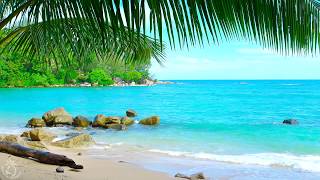
🌴 Tropical Beach Ambience on a Island in Thailand with Ocean Sounds For Relaxation & Holiday Feeling
Enjoy the sun, clear blue sea, white beach and beautiful green palm ...
Enjoy the sun, clear blue sea, white beach and beautiful green palm trees and take a tropical cocktail while watching and listening ...
Papua New Guinea is classified as Developing region: Regions characterized by lower income levels, with economies in the process of industrialization and modernization. The level of income is Lower middle income.
News – Latest Updates and Headlines from Suf
Stay informed with the most recent news and important headlines from Suf. Here’s a roundup of the latest developments.
Loading...
Please note: The data used here has been primarily extracted from satellite readings. Deviations from exact values may occur, particularly regarding the height of elevations and population density. Land area and coastline measurements refer to average values at mean high tide.