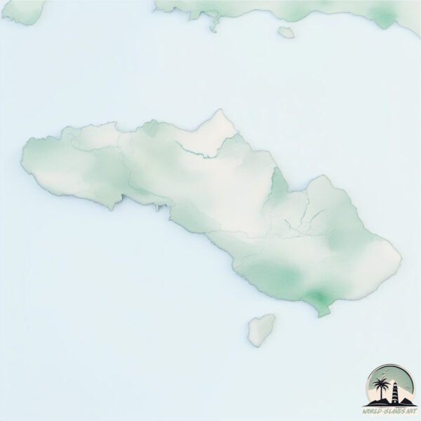
Welcome to Sumba, a Tropical island in the Indian Ocean, part of the majestic Indian Ocean. This guide offers a comprehensive overview of what makes Sumba unique – from its geography and climate to its population, infrastructure, and beyond. Dive into the details:
Geography and size of Sumba
Size: 10980 km²
Coastline: 651 km
Ocean: Indian Ocean
Sea: Indian Ocean
Continent: Asia
Sumba is a Giant Island spanning 10980 km² with a coastline of 651 km.
Archipel: Malay Archipelago – The world’s largest archipelago, located between mainland Southeast Asia and Australia, known for its immense biodiversity and cultural diversity.
Tectonic Plate: Sunda – Extends across Southeast Asia, encompassing parts of the Sunda Shelf, known for its interaction with the Australian Plate, contributing to volcanic activity in Indonesia.
The geographic heart of the island is pinpointed at these coordinates:
Latitude: -9.76269226 / Longitude: 119.96164443
Climate and weather of Sumba
Climate Zone: Tropical
Climate Details: Tropical Savanna, Wet
Temperature: Hot
Climate Characteristics: Defined by distinct wet and dry seasons with high temperatures year-round. Pronounced rainfall occurs during the wet season, while the dry season is marked by drought.
Topography and nature of Sumba
Timezone: UTC+08:00
Timezone places: Australia/Perth
Max. Elevation: 1118 m
Mean Elevation: 323 m
Vegetation: Agricultural Mosaic
Tree Coverage: 27%
The mean elevation is 323 m. The highest elevation on the island reaches approximately 1118 meters above sea level. The island is characterized by Mountains: High, steeply elevated landforms. Characterized by both a high maximum elevation (over 500 meters) and a high mean elevation, creating rugged, mountainous terrains on islands.
Dominating Vegetation: Agricultural Mosaic
A mix of cropland and natural vegetation, often seen in rural landscapes where agricultural fields are interspersed with patches of natural habitats. Sumba has a tree cover of 27 %.
Vegetation: 14 vegetation zones – Exceptionally Diverse Island
Islands with more than ten vegetation zones are among the most ecologically rich and varied in the world. These islands are akin to miniature continents, boasting an incredible array of ecosystems. The sheer range of habitats, from high peaks to deep valleys, rainforests to deserts, creates a mosaic of life that is unparalleled. They are crucial for conservation and ecological studies.
Infrastructure and Travelling to Sumba
Does the island have a public airport? yes.
Sumba has a public and scheduled airport. The following airports are located on this island: Tambolaka Airport, Umbu Mehang Kunda Airport.
Does the island have a major port? yes.
Sumba is home to a major port. The following ports are situated on the island: WAINGAPU.
The mean population of Sumba is 80 per km². Sumba is Gently Populated. The island belongs to Indonesia.
The name of the island resonates across different cultures and languages. Here is how it is known around the world: Arabic: جزيرة سومبا; German: Sumba; Spanish: Sumba; French: Sumba; Portuguese: Sumba; Russian: Сумба; Chinese: 松巴島
Continuing your journey, Pulau Mules is the next notable island, situated merely km away.
Indonesia Beyond the Tourist Zone | The Island of Sumba
On my last day of exploring Sumba, Indonesia I didn't let the rain get in the way of seeing more of this little known island, a world ...Indonesia Beyond the Tourist Zone | The Island of Sumba
On my last day of exploring Sumba, Indonesia I didn't let the rain get ...
On my last day of exploring Sumba, Indonesia I didn't let the rain get in the way of seeing more of this little known island, a world ...
Sumba, Indonesia: A Hidden Paradise of Nature & Culture
Explore Sumba, Indonesia, a land of breathtaking landscapes and rich ...
Explore Sumba, Indonesia, a land of breathtaking landscapes and rich traditions. Visit the pristine Mandorak Beach, swim in the ...
Sumba Island Indonesia travel vlog and tips
This is an hour long comprehensive travel vlog of Sumba Island, ...
This is an hour long comprehensive travel vlog of Sumba Island, specifically the West side of the island. Sumba is a little-known ...
FIRST IMPRESSIONS of SUMBA 🇮🇩 (You Won’t Believe How Locals Treat You)
Join us as we explore the untouched island of Sumba, Indonesia — a ...
Join us as we explore the untouched island of Sumba, Indonesia — a place that feels worlds away from Bali. From meeting locals ...
Best Things to do in SUMBA ISLAND
Here are the best things to do in SUMBA ISLAND! I am so excited for ...
Here are the best things to do in SUMBA ISLAND! I am so excited for you guys to explore this hidden gem. Make sure to prepare ...
Full Documentary: Journey to the UNKNOWN and FORGOTTEN island of Sumba in Lake Victoria.
Full Dumentary: Journey to the UNKNOWN and FORGOTTEN island of Sumba ...
Full Dumentary: Journey to the UNKNOWN and FORGOTTEN island of Sumba in Lake Victoria. #documentary #africa #roadtrip.
Exploring the Hidden Gems of SUMBA Island, INDONESIA🇮🇩 (First Impressions) - Sumba Vlog #1
Check the insta from MySumba to plan your trip: ...
Sumba Indonesia - 1 week traveling the island | Travelvideo
It's the ultimate adventurous destination in Indonesia. Empty beaches, ...
It's the ultimate adventurous destination in Indonesia. Empty beaches, traditional villages and amazing viewpoints, this is Sumba!
Discover Sumba—Indonesia’s best‑kept secret! 🐴✨
From the sacred Pasola horse rituals and artisan ikat weaving to ...
From the sacred Pasola horse rituals and artisan ikat weaving to pristine beaches like Weekuri Lagoon and Mandorak—immerse ...
SUMBA ISLAND, Indonesia 🇮🇩 - The Secret Paradise
The riders of Sumba Island | SLICE l Full documentary
Herman lives on a small island called Sumba, located east of Bali, in ...
Herman lives on a small island called Sumba, located east of Bali, in the Nusa Tenggara archipelago. His ancestor, Umbu Walu ...
📍Sumba, Indonesia 🇮🇩❤️
Video by @ervan_dimu @adiputramar_ @lesmoonwalkers @agirlwhoblooms —— ...
Video by @ervan_dimu @adiputramar_ @lesmoonwalkers @agirlwhoblooms —— Sumba is one of the islands of Indonesia, ...
The Real Sumba Island Indonesia (That Tourists Never See)
Most people only see the Instagram version of Sumba — clean, easy, ...
Most people only see the Instagram version of Sumba — clean, easy, perfect. But there's another side, one rooted in the Marapu ...
Sumba Island❤️ this island is for sure in my top 3 islands in Indonesia 🇮🇩
It's so pure and raw, and the nature is untouched! Definitely make ...
It's so pure and raw, and the nature is untouched! Definitely make sure to visit it when you are coming to Indonesia! My friend ...
Nusa Tenggara Timur | Explore the Exotic Sumba Island [2019]
Sumba Island is a wild and unique island in the Nusa Tenggara Timur ...
Sumba Island is a wild and unique island in the Nusa Tenggara Timur region. Nihi Sumba Resort, Weekuri Lake, and the iconic ...
Sumba Island | Indonesia’s Hidden Paradise You Must See
Sumba Island is one of Indonesia's most hidden treasures — a place ...
Sumba Island is one of Indonesia's most hidden treasures — a place where time moves slowly, traditions remain alive, and nature ...
Is the WORLD'S BEST RATED Hotel worth it?? (Nihi Sumba)
Get my free program to make viral videos that matter (1B+ views): ...
Is this Indonesia's BEST hidden gem?! Sumba Island, Indonesia
Is this Indonesia's best hidden gem? Suma Island, Indonesia is a ...
Is this Indonesia's best hidden gem? Suma Island, Indonesia is a breathtaking island and we explored some of the most incredible ...
5 Places You Can't Miss in Sumba Island 🌊
5 Places You Can't Miss in Sumba Island Tanggedu Waterfall - Known as ...
5 Places You Can't Miss in Sumba Island Tanggedu Waterfall - Known as the Grand Canyon of Sumba, Tanggedu is a ...
The Bali Rooftop #33: Marapu - Welcome to Sumba
Marapu are a solid voice for Reggae in Bali. Their roots of origin ...
Marapu are a solid voice for Reggae in Bali. Their roots of origin however, grow from Sumba, an Indonesian island further to the ...
A Minute in Paradise: The NIHI Sumba Experience
Discover NIHI Sumba, a luxury barefoot retreat and Michelin Key 3 ...
Discover NIHI Sumba, a luxury barefoot retreat and Michelin Key 3 Award-winning hotel in Indonesia. A sanctuary of wellness, ...
First impressions of WILD Sumba Island, Indonesia - Day 1
Get My Sumba Guide HERE: ...
THE HIDDEN GEM OF INDONESIA - SUMBA ISLAND
In this video we explore the breathtaking island of Sumba, one of ...
In this video we explore the breathtaking island of Sumba, one of Indonesia's most untouched and underrated travel destinations.
Forever in love with Sumba island 😍 #sumba #indonesiatravel
Sumba An island full of raw, natural beauty, incredible locations, ...
Sumba An island full of raw, natural beauty, incredible locations, beautiful beaches, mind blowing waterfalls and wonderful ...
Sumba Indonesia - The Secret Wild Horse Paradise 😍🇮🇩🌴
Welcome to Sumba Island in Indonesia! When people think about ...
Welcome to Sumba Island in Indonesia! When people think about traveling to Indonesia, they often stop at Bali and overlook ...
Indonesia is classified as Emerging region: MIKT: Mexico, Indonesia, South Korea, and Turkey – Economies recognized for their development potential and emerging market status. The level of income is Lower middle income.
News – Latest Updates and Headlines from Sumba
Stay informed with the most recent news and important headlines from Sumba. Here’s a roundup of the latest developments.
Loading...
Social Media Posts about Sumba
Loading...
Please note: The data used here has been primarily extracted from satellite readings. Deviations from exact values may occur, particularly regarding the height of elevations and population density. Land area and coastline measurements refer to average values at mean high tide.


![Nusa Tenggara Timur | Explore the Exotic Sumba Island [2019]](https://i.ytimg.com/vi/8-uMbjubqmc/mqdefault.jpg)


