Welcome to Summerland Key, a Tropical island in the Gulf of Mexico, part of the majestic Atlantic Ocean. This guide offers a comprehensive overview of what makes Summerland Key unique – from its geography and climate to its population, infrastructure, and beyond. Dive into the details:
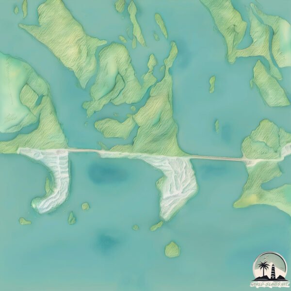
Geography and size of Summerland Key
Size: 5.019 km²
Coastline: 18.7 km
Ocean: Atlantic Ocean
Sea: Gulf of Mexico
Continent: North America
Summerland Key is a Small Island spanning 5 km² with a coastline of 18.7 km.
Archipel: –
Tectonic Plate: North America – Covers North America and parts of the Atlantic and Arctic Oceans, characterized by diverse geological features and varying levels of seismic activity.
The geographic heart of the island is pinpointed at these coordinates:
Latitude: 24.66358835 / Longitude: -81.44732069
Climate and weather of Summerland Key
Climate Zone: Tropical
Climate Details: Tropical Savanna, Wet
Temperature: Hot
Climate Characteristics: Defined by distinct wet and dry seasons with high temperatures year-round. Pronounced rainfall occurs during the wet season, while the dry season is marked by drought.
Topography and nature of Summerland Key
Timezone: UTC-05:00
Timezone places: America/New_York
Max. Elevation: 3 m
Mean Elevation: 2 m
Vegetation: Shrubland
Tree Coverage: 60%
The mean elevation is 2 m. The highest elevation on the island reaches approximately 3 meters above sea level. The island is characterized by Plains: Flat, low-lying lands characterized by a maximum elevation of up to 200 meters. On islands, plains are typically coastal lowlands or central flat areas.
Dominating Vegetation: Shrubland
Dominated by shrubs and small bushes, these areas are typical in dry, rocky, or sandy environments, as well as in regions with poor soil fertility. Summerland Key has a tree cover of 60 %.
Vegetation: 6 vegetation zones – Very Highly Diverse Island
Islands in this range are ecological powerhouses, showcasing a wide array of vegetation zones. Each zone, from lush rainforests to arid scrublands, coastal mangroves to mountainous regions, contributes to a complex and interdependent ecosystem. These islands are often hotspots of biodiversity, supporting numerous species and intricate ecological processes.
Infrastructure and Travelling to Summerland Key
Does the island have a public airport? no.
There is no public and scheduled airport on Summerland Key. The nearest airport is Key West International Airport, located 35 km away.
Does the island have a major port? no.
There are no major ports on Summerland Key. The closest major port is KEY WEST, approximately 41 km away.
The mean population of Summerland Key is 183 per km². Summerland Key is Moderately Inhabited. The island belongs to United States of America.
Continuing your journey, Torch Key is the next notable island, situated merely km away.
Why Summerland Key Is Every Boaters’ DREAM Come True
If you love life on the water, you're going to love Summerland Key. Just minutes from Key West, this Florida Keys gem is a boater's ...Why Summerland Key Is Every Boaters’ DREAM Come True
If you love life on the water, you're going to love Summerland Key. ...
If you love life on the water, you're going to love Summerland Key. Just minutes from Key West, this Florida Keys gem is a boater's ...
Summerland Key
Flying at the end of Summerland Key. #drone.
Flying at the end of Summerland Key. #drone.
🌴 Summerland Key - Florida Keys 🌴
Exploring this tropical island.
Exploring this tropical island.
The Quiet Florida Island You’ll NEVER Want to Leave
Discover what makes Cudjoe Key, Florida one of the most peaceful and ...
Discover what makes Cudjoe Key, Florida one of the most peaceful and desirable islands in the Florida Keys. Just a short drive ...
Exploring the Florida Islands by Crystal Clear Kayak - Summerland Key
Exploring the Florida Islands by Crystal Clear Kayak - Summerland Key ...
Exploring the Florida Islands by Crystal Clear Kayak - Summerland Key It's not every day you have the opportunity explore the ...
Best Islands of the Florida Keys (Differences Explained)
In this video, we'll explore some of the best islands of the Florida ...
In this video, we'll explore some of the best islands of the Florida Keys and what makes them unique. Whether you're into fishing, ...
📍5 Best Beaches In The Florida Keys ⛱️🌊🌴#visitflorida #floridakeys #beach #florida #summervibes
SUMMERLAND KEY in HD
Boat ride from canal to open water.
Boat ride from canal to open water.
The finest private estate in Summerland Key, Florida for $17,999,900
It is a great honor and pride to be accompanied with Terri Spottswood ...
It is a great honor and pride to be accompanied with Terri Spottswood (Phone : 305-292-2244) & Team Spottswood/Vazquez ...
Summerland Key by Air, Water, and Land
BIGGEST Mistakes to Avoid In The Florida Keys | Watch This Before You Visit The Keys!
Are you planning a Florida Keys Vacation? There is plenty of ...
Are you planning a Florida Keys Vacation? There is plenty of information online about visiting the Florida Keys or exploring Key ...
Summerland Key Beach - Aerial View
Oceanfront Elegance - Summerland Key Breathtaking open water views ...
Oceanfront Elegance - Summerland Key Breathtaking open water views with boating access make this area extremely attractive.
Sugarloaf Key RV Resort & Cottages | Summerland Key, Florida | Waterfront RV Camping & Glamping
Welcome to Sugarloaf Key RV Resort & Cottages! Take a tour of paradise ...
Welcome to Sugarloaf Key RV Resort & Cottages! Take a tour of paradise at Sugarloaf Key RV Resort & Cottages — where ...
The HONEST Truth About Living in Big Pine Key, Florida
Thinking about moving to Big Pine Key, Florida? In this video, I share ...
Thinking about moving to Big Pine Key, Florida? In this video, I share an honest look at the real pros and cons of living in this quiet ...
Multi-Million Dollar View (Summerland Key Fl)
Summerland Key Fun
Created with Wondershare Filmora Music by The Offspring Album: Days Go ...
Created with Wondershare Filmora Music by The Offspring Album: Days Go By Song: The Future is Now.
Underrated Summerland Key Florida
summerland , #floridalife , #floridakeys , #lobster , #cudjoesales, ...
summerland , #floridalife , #floridakeys , #lobster , #cudjoesales, #boating , #robertishere, #roadtrip.
Florida Keys Summerland Key Isles Beauty
FLORIDA KEYS SUMMERLAND KEY CHANNEL
One of the prettiest islands in the Florida Keys island chain, ...
One of the prettiest islands in the Florida Keys island chain, Summerland Key. The neighborhood of Summerland Cove Isles enjoy ...
Vacation Rental at Summerland Key
This luxurious, but cozy and comfortable, three-story home, overlooks ...
This luxurious, but cozy and comfortable, three-story home, overlooks the blue Atlantic, punctuated by small tropical islands, the ...
A Paradise for Fishermen, Pilots & Waterfront Buyers. "Summerland Key, Florida
Summerland Key is island living at its best — deep canals, clear ...
Summerland Key is island living at its best — deep canals, clear waters, a private airstrip, and quiet neighborhoods just minutes ...
Summerland Key Real Estate Video - 1355 Ocean Drive Home For Sale
Florida Keys Private Island Tour
Summerland Key History from Wikipedia: Summerland Key is an island in ...
Summerland Key History from Wikipedia: Summerland Key is an island in the lower Florida Keys about 20 miles East of Key West.
25381 1st St, Summerland Key
Summerland Beach is an upscale waterfront community in the Lower Keys! ...
Summerland Beach is an upscale waterfront community in the Lower Keys! This magnificent custom-built coastal home ...
United States of America is classified as Developed region: G7: Group of Seven – Major advanced economies, including Canada, France, Germany, Italy, Japan, the United Kingdom, and the United States. The level of income is High income: OECD.
News – Latest Updates and Headlines from Summerland Key
Stay informed with the most recent news and important headlines from Summerland Key. Here’s a roundup of the latest developments.
Loading...
Please note: The data used here has been primarily extracted from satellite readings. Deviations from exact values may occur, particularly regarding the height of elevations and population density. Land area and coastline measurements refer to average values at mean high tide.