Svenskoya
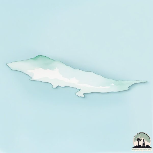
Welcome to Svenskoya, a Polar island in the Barentsz Sea, part of the majestic Arctic Ocean. This guide offers a comprehensive overview of what makes Svenskoya unique – from its geography and climate to its population, infrastructure, and beyond. Dive into the details:
- Geography and Size: Explore the island’s size and location.
- Climate and Weather: Weather patterns and temperature.
- Topography and Nature: Uncover the natural wonders of the island.
- Infrastructure and Travelling: Insights on reaching, staying, and making the most of your visit.
- News and Headlines: Latest News.
Geography and size of Svenskoya
Size: 137.1 km²
Coastline: 76.1 km
Ocean: Arctic Ocean
Sea: Barentsz Sea
Continent: Europe
Svenskoya is a Large Island spanning 137 km² with a coastline of 76 km.
Archipel: Svalbard – A Norwegian archipelago in the Arctic Ocean, known for its rugged remote terrain, polar bears, and as a center for Arctic research.
Tectonic Plate: South America – A major plate covering the South American continent and part of the Atlantic Ocean, known for the Andes mountain range and significant seismic and volcanic activity.
The geographic heart of the island is pinpointed at these coordinates:
Latitude: 78.73985503 / Longitude: 26.67450454
Climate and weather of Svenskoya
Climate Zone: Polar
Climate Details: Tundra
Temperature: Cold
Climate Characteristics: The tundra climate features long, extremely cold winters and short, cool summers. Vegetation is limited to mosses, lichens, and small shrubs due to the low temperatures and short growing seasons. Biodiversity is low, but some specialized species thrive.
Topography and nature of Svenskoya
Timezone: UTC+01:00
Timezone places: Europe/Paris
Max. Elevation: 270 m
Mean Elevation: 77 m
Vegetation: Sparse Vegetation
Tree Coverage: 39%
The mean elevation is 77 m. The highest elevation on the island reaches approximately 270 meters above sea level. The island is characterized by Hills: Gently sloping landforms with rounded tops, having a maximum elevation between 200 and 500 meters. Hills contribute to a varied landscape on islands.
Dominating Vegetation: Sparse Vegetation
These regions have limited plant growth, typically due to extreme conditions like aridity or poor soils. Vegetation is scattered and consists of hardy plant species. Svenskoya has a tree cover of 39 %.
Vegetation: 4 vegetation zones – Diverse Island
Four distinct vegetation zones mark these islands as ecologically diverse. They might feature varied landscapes such as forests, beaches, grasslands, and rocky areas. Such diversity reflects the island’s complex ecological interactions and varied habitats, which can support a rich array of wildlife and plant species.
Infrastructure and Travelling to Svenskoya
Does the island have a public airport? no.
There is no public and scheduled airport on Svenskoya. The nearest airport is Honningsvåg Airport, Valan, located 852 km away.
Does the island have a major port? no.
There are no major ports on Svenskoya. The closest major port is HONNINGSVAG, approximately 855 km away.
The mean population of Svenskoya is 0 per km². Svenskoya is Uninhabited. The island belongs to Norway.
Continuing your journey, Kongsoya is the next notable island, situated merely km away.
Artic Ocean Norwegian Sea Svenskoya Island in Svalbard Group Norway In Google Earth and Google Maps


Norway is classified as Developed region: nonG7: Developed economies outside of the Group of Seven, characterized by high income and advanced economic structures. The level of income is High income: OECD.
News – Latest Updates and Headlines from Svenskoya
Stay informed with the most recent news and important headlines from Svenskoya. Here’s a roundup of the latest developments.
Please note: The data used here has been primarily extracted from satellite readings. Deviations from exact values may occur, particularly regarding the height of elevations and population density. Land area and coastline measurements refer to average values at mean high tide.