Welcome to Sydney, a Tropical island in the Arafura Sea, part of the majestic Indian Ocean. This guide offers a comprehensive overview of what makes Sydney unique – from its geography and climate to its population, infrastructure, and beyond. Dive into the details:
Geography and size of Sydney
Size: 10.4 km²
Coastline: 18.4 km
Ocean: Indian Ocean
Sea: Arafura Sea
Continent: Oceania
Sydney is a Medium Island spanning 10 km² with a coastline of 18 km.
Archipel: –
Tectonic Plate: Australia – A major tectonic plate covering Australia, New Zealand, and parts of the Indian and Pacific Oceans, known for its relative stability and occasional seismic activity.
The geographic heart of the island is pinpointed at these coordinates:
Latitude: -16.68888718 / Longitude: 139.45664407
Climate and weather of Sydney
Climate Zone: Tropical
Climate Details: Tropical Savanna, Wet
Temperature: Hot
Climate Characteristics: Defined by distinct wet and dry seasons with high temperatures year-round. Pronounced rainfall occurs during the wet season, while the dry season is marked by drought.
Topography and nature of Sydney
Timezone: UTC+10:00
Timezone places: Australia/Sydney
Max. Elevation: 11 m
Mean Elevation: 7 m
Vegetation: Evergreen Broadleaf Forest
Tree Coverage: 55%
The mean elevation is 7 m. The highest elevation on the island reaches approximately 11 meters above sea level. The island is characterized by Plains: Flat, low-lying lands characterized by a maximum elevation of up to 200 meters. On islands, plains are typically coastal lowlands or central flat areas.
Dominating Vegetation: Evergreen Broadleaf Forest
Characterized by dense, lush canopies of broadleaf trees that retain their leaves year-round. These forests are typically found in tropical and subtropical regions and are known for their high biodiversity. Sydney has a tree cover of 55 %.
Vegetation: 7 vegetation zones – Very Highly Diverse Island
Islands in this range are ecological powerhouses, showcasing a wide array of vegetation zones. Each zone, from lush rainforests to arid scrublands, coastal mangroves to mountainous regions, contributes to a complex and interdependent ecosystem. These islands are often hotspots of biodiversity, supporting numerous species and intricate ecological processes.
Infrastructure and Travelling to Sydney
Does the island have a public airport? no.
There is no public and scheduled airport on Sydney. The nearest airport is Mornington Island Airport, located 29 km away.
Does the island have a major port? no.
There are no major ports on Sydney. The closest major port is KARUMBA, approximately 175 km away.
The mean population of Sydney is 0 per km². Sydney is Uninhabited. The island belongs to Australia.
Continuing your journey, Mornington is the next notable island, situated merely km away.
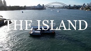
TOBIAHS 003: SYDNEY, THE ISLAND
TOBIAHS 00* is a series of intimate parties sharing Tobiahs' new and unreleased music in unique spaces across Australia and ...TOBIAHS 003: SYDNEY, THE ISLAND
TOBIAHS 00* is a series of intimate parties sharing Tobiahs' new and ...
TOBIAHS 00* is a series of intimate parties sharing Tobiahs' new and unreleased music in unique spaces across Australia and ...
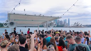
SUMMER LAUNCH 2025 | THE ISLAND, SYDNEY
The Island 2025 season is here and we are excited to showcase our ...
The Island 2025 season is here and we are excited to showcase our iconic venue in this exclusive DJ set live on Sydney Harbour.
The Island - An Exclusive Water Venue
The Island is Australia's floating beach club that operates from ...
The Island is Australia's floating beach club that operates from Sydney Harbour.
Camping at Cockatoo Island, Sydney Harbour, NSW with the Gibson Family
Join the Gibson family as they explore Cockatoo Island and get to ...
Join the Gibson family as they explore Cockatoo Island and get to spend a night camping on Sydney Harbour.
Ghosts of Cockatoo Island Prison: Haunted Sydney
CockatooIsland #HauntedSydney #GhostStories #HauntedPrison ...
CockatooIsland #HauntedSydney #GhostStories #HauntedPrison #AustraliaHaunted #CreepyExperiences Uncover the chilling ...
Big plans to transform Cockatoo Island into a crown jewel of Sydney Harbour | 7NEWS
Cockatoo Island is undergoing a big transformation to make it a jewel ...
Cockatoo Island is undergoing a big transformation to make it a jewel in Sydney Harbour. Subscribe and set ...
Daire @ Glass Island, Sydney, Australia
Daire @ Glass Island, Sydney, Australia.
Daire @ Glass Island, Sydney, Australia.
BEST PLACE TO VISIT IN AUSTRALIA - SYDNEY ISLAND
BEST PLACE TO VISIT IN AUSTRALIA - SYDNEY ISLAND Sydney is the largest ...
BEST PLACE TO VISIT IN AUSTRALIA - SYDNEY ISLAND Sydney is the largest city in Australia, and the capital of the state of ...
REGARD LIVE @ Glass Island - Sydney, Australia 2024
Regard at Glass Island, Sydney, Australia - 1h DJ LIVE SET Spotify ...
View of Sydney Harbour Bridge from Cockatoo Island#sydney #australia
Do watch full video vlog of Cockatoo Island History ...
Discover Sydney's Secret Island Gem Cockatoo Island
Join me on an adventure as I uncover the secrets of Cockatoo Island, a ...
Join me on an adventure as I uncover the secrets of Cockatoo Island, a hidden gem in the heart of Sydney Harbour! From its rich ...
Sydney to Moreton Island: Your Next Carnival Cruise Adventure
Ready to explore Queensland's hidden gem? Discover Tangalooma Moreton ...
Ready to explore Queensland's hidden gem? Discover Tangalooma Moreton Island, the world's third largest sand island and one ...
See how Cockatoo Island was transformed into Sydney Harbour for #TenPoundPoms. #StanOriginals
Go behind the scenes and see how Cockatoo Island was transformed into ...
Go behind the scenes and see how Cockatoo Island was transformed into the iconic Sydney Harbour for the Stan Original Series ...
You can buy entire island for price of Sydney home
Temple Island off the the Central Queensland Coast, just one hour from ...
Temple Island off the the Central Queensland Coast, just one hour from Mackay, is on the market for just $1.75m.
Sydney’s BEST Pacific Island Food Secret! - A Hidden GEM in Leumeah. Ep.3
On today's Roam, we are on a mission to uncover a secret spot that is ...
On today's Roam, we are on a mission to uncover a secret spot that is literally “HIDDEN” in Sydney! We're roaming deep into ...
Best Things To Do in Sydney Australia 4K
SYDNEY, AUSTRALIA : In this Sydney travel guide. We show you all the ...
SYDNEY, AUSTRALIA : In this Sydney travel guide. We show you all the best things to do in Sydney and top tourist spots in ...
Patrick Topping Live @ Glass Island Sydney 2023
Subscribe to my channel: ...
Boat party in Glass Island - Sydney 🛥️ #sydney #glassisland
Book a guided history tour at Cockatoo Island, Sydney Harbour
Eager to experience a different side to Sydney? Journey to Cockatoo ...
Eager to experience a different side to Sydney? Journey to Cockatoo Island's storied convict and dockyard eras with our guided ...
Sydney Hidden Island: SCOTLAND ISLAND
If you're in need of a weekend away from Sydney, Scotland Island is ...
If you're in need of a weekend away from Sydney, Scotland Island is only 50 minutes north of the CBD located in Pittwater.
Sailing Silly to Sydney Island
All drone shots of a short sailing trip to Sydney Island off of Sydney ...
All drone shots of a short sailing trip to Sydney Island off of Sydney BC, Canada.
Book a night tour at Cockatoo Island, Sydney Harbour (portrait)
Want to discover a mysterious side to Sydney Harbour? Book a night ...
Want to discover a mysterious side to Sydney Harbour? Book a night tour at Cockatoo Island! We offer two different night tours ...
Beach Club on The Island Sydney
The Island Sydney brings the European Beach Club culture to Sydney ...
The Island Sydney brings the European Beach Club culture to Sydney Harbour, providing an exceptional experience for both ...
Australia is classified as Developed region: nonG7: Developed economies outside of the Group of Seven, characterized by high income and advanced economic structures. The level of income is High income: OECD.
News – Latest Updates and Headlines from Sydney
Stay informed with the most recent news and important headlines from Sydney. Here’s a roundup of the latest developments.
Loading...
Please note: The data used here has been primarily extracted from satellite readings. Deviations from exact values may occur, particularly regarding the height of elevations and population density. Land area and coastline measurements refer to average values at mean high tide.