Tarāsa Dwīp
Welcome to Tarāsa Dwīp, a Tropical island in the Andaman or Burma Sea, part of the majestic Indian Ocean. This guide offers a comprehensive overview of what makes Tarāsa Dwīp unique – from its geography and climate to its population, infrastructure, and beyond. Dive into the details:
- Geography and Size: Explore the island’s size and location.
- Climate and Weather: Weather patterns and temperature.
- Topography and Nature: Uncover the natural wonders of the island.
- Infrastructure and Travelling: Insights on reaching, staying, and making the most of your visit.
- News and Headlines: Latest News.
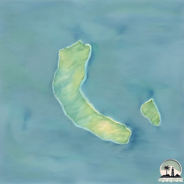
Geography and size of Tarāsa Dwīp
Size: 85.9 km²
Coastline: 56 km
Ocean: Indian Ocean
Sea: Andaman or Burma Sea
Continent: Seven seas (open ocean)
Tarāsa Dwīp is a Medium Island spanning 86 km² with a coastline of 56 km.
Archipel: Nicobar Islands – Part of a group of islands in the Indian Ocean, these are known for their stunning beaches, diverse ecosystems, and unique indigenous cultures.
Tectonic Plate: India – A major tectonic plate that initially moved northward at a rapid pace before colliding with the Eurasian Plate. This collision is responsible for the uplift of the Himalayas and the Tibetan Plateau.
The geographic heart of the island is pinpointed at these coordinates:
Latitude: 8.26948384 / Longitude: 93.13076287
Climate and weather of Tarāsa Dwīp
Climate Zone: Tropical
Climate Details: Tropical Monsoon Climate
Temperature: Hot
Climate Characteristics: Characterized by heavy rainfall, high humidity, and uniformly high temperatures, but with a distinct short dry season. It features a seasonal reversal of prevailing wind directions.
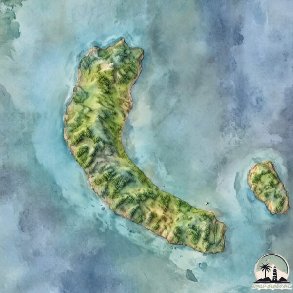
Topography and nature of Tarāsa Dwīp
Timezone: UTC+05:30
Timezone places:
Max. Elevation: 213 m
Mean Elevation: 51 m
Vegetation: Agricultural Mosaic
Tree Coverage: 30%
The mean elevation is 51 m. The highest elevation on the island reaches approximately 213 meters above sea level. The island is characterized by Hills: Gently sloping landforms with rounded tops, having a maximum elevation between 200 and 500 meters. Hills contribute to a varied landscape on islands.
Dominating Vegetation: Agricultural Mosaic
A mix of cropland and natural vegetation, often seen in rural landscapes where agricultural fields are interspersed with patches of natural habitats. Tarāsa Dwīp has a tree cover of 30 %.
Vegetation: 9 vegetation zones – Very Highly Diverse Island
Islands in this range are ecological powerhouses, showcasing a wide array of vegetation zones. Each zone, from lush rainforests to arid scrublands, coastal mangroves to mountainous regions, contributes to a complex and interdependent ecosystem. These islands are often hotspots of biodiversity, supporting numerous species and intricate ecological processes.
Infrastructure and Travelling to Tarāsa Dwīp
Does the island have a public airport? no.
There is no public and scheduled airport on Tarāsa Dwīp. The nearest airport is Veer Savarkar International Airport / INS Utkrosh, located 368 km away.
Does the island have a major port? no.
There are no major ports on Tarāsa Dwīp. The closest major port is SABANG, approximately 348 km away.
The mean population of Tarāsa Dwīp is 19 per km². Tarāsa Dwīp is Gently Populated. The island belongs to India.
Continuing your journey, Camorta is the next notable island, situated merely km away.
Teressa Island - The Hidden Life Styles


India is classified as Emerging region: BRIC: Brazil, Russia, India, and China – Economies noted for their rapid growth and increasing influence on global affairs. The level of income is Lower middle income.
News – Latest Updates and Headlines from Tarāsa Dwīp
Stay informed with the most recent news and important headlines from Tarāsa Dwīp. Here’s a roundup of the latest developments.
Please note: The data used here has been primarily extracted from satellite readings. Deviations from exact values may occur, particularly regarding the height of elevations and population density. Land area and coastline measurements refer to average values at mean high tide.