Tenerife
Welcome to Tenerife, a Temperate island in the North Atlantic Ocean, part of the majestic Atlantic Ocean. This guide offers a comprehensive overview of what makes Tenerife unique – from its geography and climate to its population, infrastructure, and beyond. Dive into the details:
- Geography and Size: Explore the island’s size and location.
- Climate and Weather: Weather patterns and temperature.
- Topography and Nature: Uncover the natural wonders of the island.
- Infrastructure and Travelling: Insights on reaching, staying, and making the most of your visit.
- News and Headlines: Latest News.
Geography and size of Tenerife
Size: 2047 km²
Coastline: 302 km
Ocean: Atlantic Ocean
Sea: North Atlantic Ocean
Continent: Africa
Tenerife is a Very Large Island spanning 2047 km² with a coastline of 302 km.
Archipel: Canary Islands – A Spanish archipelago off the coast of northwestern Africa, known for their volcanic landscapes, unique ecosystems, and vibrant cultures.
Tectonic Plate: Africa – One of the world’s largest tectonic plates, covering the African continent and parts of the surrounding oceans, known for its stability with some active rift zones.
The geographic heart of the island is pinpointed at these coordinates:
Latitude: 28.2915565 / Longitude: -16.55668329
Climate and weather of Tenerife
Climate Zone: Temperate
Climate Details: Warm-Summer Mediterranean Climate
Temperature: Warm Summer
Climate Characteristics: Characterized by warm, dry summers and mild, wet winters, typical of coastal areas with abundant sunshine Rain is more common in the winter months, maintaining a moderate climate.
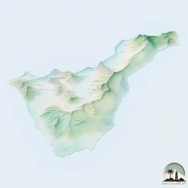
Topography and nature of Tenerife
Timezone: UTC±00:00
Timezone places: Europe/Lisbon
Max. Elevation: 3718 m El Pico del Teide
Mean Elevation: 872 m
Vegetation: Shrubland
Tree Coverage: 19%
The mean elevation is 872 m. Dominating the island’s landscape, the majestic “El Pico del Teide” rises as the highest peak, soaring to impressive heights. The island is characterized by Mountains: High, steeply elevated landforms. Characterized by both a high maximum elevation (over 500 meters) and a high mean elevation, creating rugged, mountainous terrains on islands.
Dominating Vegetation: Shrubland
Dominated by shrubs and small bushes, these areas are typical in dry, rocky, or sandy environments, as well as in regions with poor soil fertility. Tenerife has a tree cover of 19 %.
Vegetation: 13 vegetation zones – Exceptionally Diverse Island
Islands with more than ten vegetation zones are among the most ecologically rich and varied in the world. These islands are akin to miniature continents, boasting an incredible array of ecosystems. The sheer range of habitats, from high peaks to deep valleys, rainforests to deserts, creates a mosaic of life that is unparalleled. They are crucial for conservation and ecological studies.
Infrastructure and Travelling to Tenerife
Does the island have a public airport? yes.
Tenerife has a public and scheduled airport. The following airports are located on this island: Tenerife Sur Airport, Tenerife Norte-Ciudad de La Laguna Airport.
Does the island have a major port? no.
There are no major ports on Tenerife. The closest major port is SANTA CRUZ DE TENERIFE, approximately 1 km away.
The mean population of Tenerife is 518 per km². Tenerife is Densely Populated. The island belongs to Spain.
The name of the island resonates across different cultures and languages. Here is how it is known around the world: Arabic: تنريفي; German: Teneriffa; Spanish: Tenerife; French: Ténérife; Portuguese: Tenerife; Russian: Тенерифе; Chinese: 特内里费岛
Continuing your journey, Gomera is the next notable island, situated merely km away.
Top 10 Things To Do In TENERIFE


Spain is classified as Developed region: nonG7: Developed economies outside of the Group of Seven, characterized by high income and advanced economic structures. The level of income is High income: OECD.
News – Latest Updates and Headlines from Tenerife
Stay informed with the most recent news and important headlines from Tenerife. Here’s a roundup of the latest developments.
- Santander to Lanzarote Binter Daily Flights Enhance Canary Islands Tourism Connectivity: What You Need to Know - Travel And Tour Worldon 2 April 2026
Santander to Lanzarote Binter Daily Flights Enhance Canary Islands Tourism Connectivity: What You Need to Know Travel And Tour World
- UK Tourists Tenerife Travel Alert: Spain’s Canary Islands Introduce Stricter Measures Amid Overcrowding Concerns This April Travel Season - Travel And Tour Worldon 1 April 2026
UK Tourists Tenerife Travel Alert: Spain’s Canary Islands Introduce Stricter Measures Amid Overcrowding Concerns This April Travel Season Travel And Tour World
- Tenerife tourists left disappointed as unlikely problem 'ruins holidays' - Irish Mirroron 1 April 2026
Tenerife tourists left disappointed as unlikely problem 'ruins holidays' Irish Mirror
- Tourists in Tenerife left saddened as unexpected issue 'ruins holidays' - Manchester Evening Newson 1 April 2026
Tourists in Tenerife left saddened as unexpected issue 'ruins holidays' Manchester Evening News
- UK tourists hit with new rules in Tenerife and Lanzarote from April 10 - warning issued - Daily Expresson 1 April 2026
UK tourists hit with new rules in Tenerife and Lanzarote from April 10 - warning issued Daily Express
- British tourists in Tenerife disappointed after unlikely aspect 'ruins holidays' - The Mirroron 1 April 2026
British tourists in Tenerife disappointed after unlikely aspect 'ruins holidays' The Mirror
- Intense calima begins to clear from Canary Islands skies this Wednesday - Guide To Canary Islandson 1 April 2026
Intense calima begins to clear from Canary Islands skies this Wednesday Guide To Canary Islands
- Canary Islands health warning to 6 vulnerable types of tourists as 'adverse weather' looms - Liverpool Echoon 31 March 2026
Canary Islands health warning to 6 vulnerable types of tourists as 'adverse weather' looms Liverpool Echo
- Six types of Canary Islands tourists issued health warning and told to shut windows - Manchester Evening Newson 31 March 2026
Six types of Canary Islands tourists issued health warning and told to shut windows Manchester Evening News
- Christine Tongue: What Tenerife can learn from Thanet - The Isle of Thanet Newson 31 March 2026
Christine Tongue: What Tenerife can learn from Thanet The Isle of Thanet News
Social Media Posts about Tenerife
Please note: The data used here has been primarily extracted from satellite readings. Deviations from exact values may occur, particularly regarding the height of elevations and population density. Land area and coastline measurements refer to average values at mean high tide.