Tetepare
Welcome to Tetepare, a Tropical island in the Solomon Sea, part of the majestic Pacific Ocean. This guide offers a comprehensive overview of what makes Tetepare unique – from its geography and climate to its population, infrastructure, and beyond. Dive into the details:
- Geography and Size: Explore the island’s size and location.
- Climate and Weather: Weather patterns and temperature.
- Topography and Nature: Uncover the natural wonders of the island.
- Infrastructure and Travelling: Insights on reaching, staying, and making the most of your visit.
- News and Headlines: Latest News.
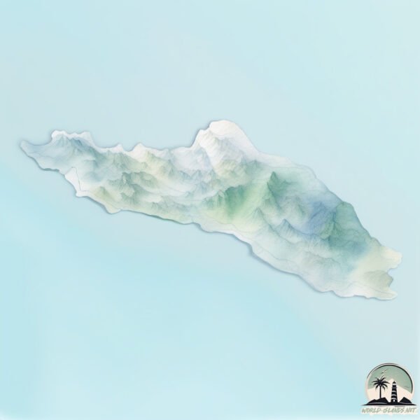
Geography and size of Tetepare
Size: 126.6 km²
Coastline: 67.8 km
Ocean: Pacific Ocean
Sea: Solomon Sea
Continent: Oceania
Tetepare is a Large Island spanning 127 km² with a coastline of 68 km.
Archipel: Melanesia – A subregion of Oceania in the southwestern Pacific Ocean, including countries like Fiji, Solomon Islands, and Vanuatu, known for their diverse cultures and languages.
Tectonic Plate: Sunda – Extends across Southeast Asia, encompassing parts of the Sunda Shelf, known for its interaction with the Australian Plate, contributing to volcanic activity in Indonesia.
The geographic heart of the island is pinpointed at these coordinates:
Latitude: -8.74331271 / Longitude: 157.55759706
Climate and weather of Tetepare
Climate Zone: Tropical
Climate Details: Tropical Rainforest Climate
Temperature: Hot
Climate Characteristics: This climate is typified by heavy rainfall throughout the year, high humidity, and consistently high temperatures, leading to lush rainforests and rich biodiversity. Seasonal temperature variations are minimal.
Topography and nature of Tetepare
Timezone: UTC+11:00
Timezone places: Pacific/Guadalcanal
Max. Elevation: 334 m
Mean Elevation: 148 m
Vegetation: Evergreen Broadleaf Forest
Tree Coverage: 85%
The mean elevation is 148 m. The highest elevation on the island reaches approximately 334 meters above sea level. The island is characterized by Hills: Gently sloping landforms with rounded tops, having a maximum elevation between 200 and 500 meters. Hills contribute to a varied landscape on islands.
Dominating Vegetation: Evergreen Broadleaf Forest
Characterized by dense, lush canopies of broadleaf trees that retain their leaves year-round. These forests are typically found in tropical and subtropical regions and are known for their high biodiversity. Tetepare has a tree cover of 85 %.
Vegetation: 8 vegetation zones – Very Highly Diverse Island
Islands in this range are ecological powerhouses, showcasing a wide array of vegetation zones. Each zone, from lush rainforests to arid scrublands, coastal mangroves to mountainous regions, contributes to a complex and interdependent ecosystem. These islands are often hotspots of biodiversity, supporting numerous species and intricate ecological processes.
Infrastructure and Travelling to Tetepare
Does the island have a public airport? no.
There is no public and scheduled airport on Tetepare. The nearest airport is Munda Airport, located 46 km away.
Does the island have a major port? no.
There are no major ports on Tetepare. The closest major port is PORT NORO, approximately 61 km away.
The mean population of Tetepare is 2 per km². Tetepare is Gently Populated. The island belongs to Solomon Islands.
Continuing your journey, Rendova is the next notable island, situated merely km away.
Dark history of the largest uninhabited Pacific Island | The Pacific | ABC News


Solomon Islands is classified as Least developed region: Countries that exhibit the lowest indicators of socioeconomic development, with the lowest Human Development Index ratings. The level of income is Lower middle income.
News – Latest Updates and Headlines from Tetepare
Stay informed with the most recent news and important headlines from Tetepare. Here’s a roundup of the latest developments.
- Strengthening Governance, Conservation of Tetepare Island through TDA - Solomon Star Newson 4 February 2026
Strengthening Governance, Conservation of Tetepare Island through TDA Solomon Star News
- The scientist who helped win the fight to protect a sacred piece of the Pacific | Solomon Islands - The Guardianon 14 November 2025
The scientist who helped win the fight to protect a sacred piece of the Pacific | Solomon Islands The Guardian
- Why Is Tetepare the South Pacific’s Largest Uninhabited Island? - Smithsonian Magazineon 25 August 2025
Why Is Tetepare the South Pacific’s Largest Uninhabited Island? Smithsonian Magazine
- Elusive ‘noodlefish’ from uninhabited island found as a pet 3,500 miles away - Miami Heraldon 25 July 2025
Elusive ‘noodlefish’ from uninhabited island found as a pet 3,500 miles away Miami Herald
- Searching for snails across the Pacific, part 2: Tetepare - Australian Museumon 22 July 2025
Searching for snails across the Pacific, part 2: Tetepare Australian Museum
- Tetepare Island Earthquakes Archive: Past Quakes on Thursday, June 5th, 2025 - Volcano Discoveryon 5 June 2025
Tetepare Island Earthquakes Archive: Past Quakes on Thursday, June 5th, 2025 Volcano Discovery
- Tetepare Island Earthquakes Archive: Past Quakes in 2024 - Volcano Discoveryon 14 March 2025
Tetepare Island Earthquakes Archive: Past Quakes in 2024 Volcano Discovery
- TDA benefits from record opportunities - Solomon Star Newson 15 October 2024
TDA benefits from record opportunities Solomon Star News
- After humans abandoned this island, it became a land outside time. Their descendants are fighting to keep it that way - Australian Broadcasting Corporationon 22 May 2024
After humans abandoned this island, it became a land outside time. Their descendants are fighting to keep it that way Australian Broadcasting Corporation
- Zizirae Island, Solomon Islands, Earthquakes: Latest Quakes - Volcano Discoveryon 31 March 2024
Zizirae Island, Solomon Islands, Earthquakes: Latest Quakes Volcano Discovery
Please note: The data used here has been primarily extracted from satellite readings. Deviations from exact values may occur, particularly regarding the height of elevations and population density. Land area and coastline measurements refer to average values at mean high tide.