Tiaruanu
Welcome to Tiaruanu, a Tropical island in the South Pacific Ocean, part of the majestic Pacific Ocean. This guide offers a comprehensive overview of what makes Tiaruanu unique – from its geography and climate to its population, infrastructure, and beyond. Dive into the details:
- Geography and Size: Explore the island’s size and location.
- Climate and Weather: Weather patterns and temperature.
- Topography and Nature: Uncover the natural wonders of the island.
- Infrastructure and Travelling: Insights on reaching, staying, and making the most of your visit.
- News and Headlines: Latest News.
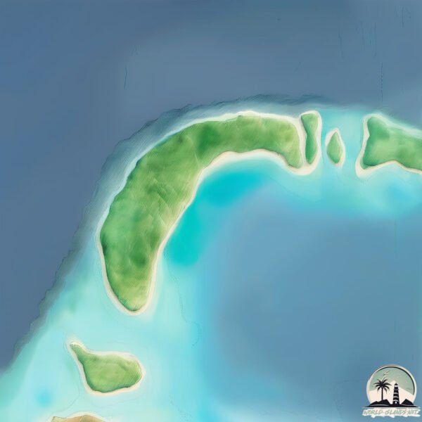
Geography and size of Tiaruanu
Size: 1.855 km²
Coastline: 7.8 km
Ocean: Pacific Ocean
Sea: South Pacific Ocean
Continent: Oceania
Tiaruanu is a Small Island spanning 1.9 km² with a coastline of 7.8 km.
Archipel: Society Islands – A group of islands in the South Pacific Ocean, part of French Polynesia, famous for their idyllic beauty, including Tahiti and Bora Bora.
Tectonic Plate: Pacific – The world’s largest tectonic plate, covering much of the Pacific Ocean, known for the Pacific Ring of Fire with extensive seismic and volcanic activity.
The geographic heart of the island is pinpointed at these coordinates:
Latitude: -16.99108545 / Longitude: -149.57743327
Climate and weather of Tiaruanu
Climate Zone: Tropical
Climate Details: Tropical Rainforest Climate
Temperature: Hot
Climate Characteristics: This climate is typified by heavy rainfall throughout the year, high humidity, and consistently high temperatures, leading to lush rainforests and rich biodiversity. Seasonal temperature variations are minimal.
Topography and nature of Tiaruanu
Timezone: UTC-10:00
Timezone places: Pacific/Honolulu
Max. Elevation: 6 m
Mean Elevation: -4 m
Vegetation: Shrubland
Tree Coverage: 65%
The mean elevation is -4 m. The highest elevation on the island reaches approximately 6 meters above sea level. The island is characterized by Plains: Flat, low-lying lands characterized by a maximum elevation of up to 200 meters. On islands, plains are typically coastal lowlands or central flat areas.
Dominating Vegetation: Shrubland
Dominated by shrubs and small bushes, these areas are typical in dry, rocky, or sandy environments, as well as in regions with poor soil fertility. Tiaruanu has a tree cover of 65 %.
Vegetation: 4 vegetation zones – Diverse Island
Four distinct vegetation zones mark these islands as ecologically diverse. They might feature varied landscapes such as forests, beaches, grasslands, and rocky areas. Such diversity reflects the island’s complex ecological interactions and varied habitats, which can support a rich array of wildlife and plant species.
Infrastructure and Travelling to Tiaruanu
Does the island have a public airport? no.
There is no public and scheduled airport on Tiaruanu. The nearest airport is Moorea Temae Airport, located 58 km away.
Does the island have a major port? no.
There are no major ports on Tiaruanu. The closest major port is PAPEETE, approximately 59 km away.
The mean population of Tiaruanu is 500 per km². Tiaruanu is Moderately Inhabited. The island belongs to France.
Continuing your journey, Moorea is the next notable island, situated merely km away.
5 things you should know before going to Tahiti ! #tahiti #travel #travelguide

France is classified as Developed region: G7: Group of Seven – Major advanced economies, including Canada, France, Germany, Italy, Japan, the United Kingdom, and the United States. The level of income is High income: OECD.
News – Latest Updates and Headlines from Tiaruanu
Stay informed with the most recent news and important headlines from Tiaruanu. Here’s a roundup of the latest developments.
Please note: The data used here has been primarily extracted from satellite readings. Deviations from exact values may occur, particularly regarding the height of elevations and population density. Land area and coastline measurements refer to average values at mean high tide.