Timor
Welcome to Timor, a Tropical island in the Timor Sea, part of the majestic Indian Ocean. This guide offers a comprehensive overview of what makes Timor unique – from its geography and climate to its population, infrastructure, and beyond. Dive into the details:
- Geography and Size: Explore the island’s size and location.
- Climate and Weather: Weather patterns and temperature.
- Topography and Nature: Uncover the natural wonders of the island.
- Infrastructure and Travelling: Insights on reaching, staying, and making the most of your visit.
- News and Headlines: Latest News.
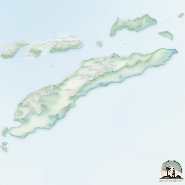
Geography and size of Timor
Size: 28791 km²
Coastline: 1359 km
Ocean: Indian Ocean
Sea: Timor Sea
Continent: Asia
Timor is a Giant Island spanning 28791 km² with a coastline of 1359 km.
Archipel: Malay Archipelago – The world’s largest archipelago, located between mainland Southeast Asia and Australia, known for its immense biodiversity and cultural diversity.
Tectonic Plate: Timor – A small tectonic plate in the Timor region, primarily under the Timor Sea. It’s involved in the collision between the Australian and Eurasian plates, contributing to the region’s seismic activity and the uplift of the island of Timor.
The geographic heart of the island is pinpointed at these coordinates:
Latitude: -9.24777312 / Longitude: 125.11218277
Climate and weather of Timor
Climate Zone: Tropical
Climate Details: Tropical Savanna, Wet
Temperature: Hot
Climate Characteristics: Defined by distinct wet and dry seasons with high temperatures year-round. Pronounced rainfall occurs during the wet season, while the dry season is marked by drought.
Topography and nature of Timor
Timezone: UTC+08:00
Timezone places: Australia/Perth
Max. Elevation: 2963 m Mt. Ramelau
Mean Elevation: 437 m
Vegetation: Agricultural Mosaic
Tree Coverage: 28%
The mean elevation is 437 m. Dominating the island’s landscape, the majestic “Mt. Ramelau” rises as the highest peak, soaring to impressive heights. The island is characterized by Mountains: High, steeply elevated landforms. Characterized by both a high maximum elevation (over 500 meters) and a high mean elevation, creating rugged, mountainous terrains on islands.
Dominating Vegetation: Agricultural Mosaic
A mix of cropland and natural vegetation, often seen in rural landscapes where agricultural fields are interspersed with patches of natural habitats. Timor has a tree cover of 28 %.
Vegetation: 15 vegetation zones – Exceptionally Diverse Island
Islands with more than ten vegetation zones are among the most ecologically rich and varied in the world. These islands are akin to miniature continents, boasting an incredible array of ecosystems. The sheer range of habitats, from high peaks to deep valleys, rainforests to deserts, creates a mosaic of life that is unparalleled. They are crucial for conservation and ecological studies.
Infrastructure and Travelling to Timor
Does the island have a public airport? yes.
Timor has a public and scheduled airport. The following airports are located on this island: El Tari Airport, Presidente Nicolau Lobato International Airport, AA Bere Tallo (Haliwen) Airport.
Does the island have a major port? yes.
Timor is home to a major port. The following ports are situated on the island: KUPANG.
The mean population of Timor is 120 per km². Timor is Moderately Inhabited. The island belongs to East Timor.
The name of the island resonates across different cultures and languages. Here is how it is known around the world: Arabic: تيمور; German: Timor; Spanish: Timor; French: Timor; Portuguese: Timor; Russian: Тимор; Chinese: 帝汶
Continuing your journey, Jaco is the next notable island, situated merely km away.
East Timor, the forgotten Portuguese speaking country


East Timor is classified as Least developed region: Countries that exhibit the lowest indicators of socioeconomic development, with the lowest Human Development Index ratings. The level of income is Lower middle income.
News – Latest Updates and Headlines from Timor
Stay informed with the most recent news and important headlines from Timor. Here’s a roundup of the latest developments.
Social Media Posts about Timor
Please note: The data used here has been primarily extracted from satellite readings. Deviations from exact values may occur, particularly regarding the height of elevations and population density. Land area and coastline measurements refer to average values at mean high tide.