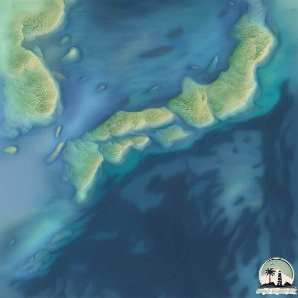
Welcome to To Shima, a Temperate island in the Philippine Sea, part of the majestic Pacific Ocean. This guide offers a comprehensive overview of what makes To Shima unique – from its geography and climate to its population, infrastructure, and beyond. Dive into the details:
Geography and size of To Shima
Size: 4.035 km²
Coastline: 9.7 km
Ocean: Pacific Ocean
Sea: Philippine Sea
Continent: Asia
To Shima is a Small Island spanning 4 km² with a coastline of 9.7 km.
Archipel: Japan – An East Asian archipelago comprising four main islands and numerous smaller ones, known for its rich history, technological advances, and distinct culture.
Tectonic Plate: Amur – A minor tectonic plate in the region of the Amur River at the border of Russia and China, involved in complex interactions with the Pacific and Eurasian plates.
The geographic heart of the island is pinpointed at these coordinates:
Latitude: 34.27640795 / Longitude: 138.3058631
Climate and weather of To Shima
Climate Zone: Temperate
Climate Details: Humid Subtropical Climate
Temperature: Hot Summer
Climate Characteristics: With continuous rainfall and hot summers, this climate is common in some coastal regions, supporting diverse vegetation.
Topography and nature of To Shima
Timezone: UTC+09:00
Timezone places: Asia/Tokyo
Max. Elevation: 362 m
Mean Elevation: 110 m
Vegetation: Evergreen Needleleaf Forest
Tree Coverage: 94%
The mean elevation is 110 m. The highest elevation on the island reaches approximately 362 meters above sea level. The island is characterized by Hills: Gently sloping landforms with rounded tops, having a maximum elevation between 200 and 500 meters. Hills contribute to a varied landscape on islands.
Dominating Vegetation: Evergreen Needleleaf Forest
Dominated by evergreen coniferous trees such as pines and firs, which retain their needle-like leaves throughout the year. These forests are often found in cooler climates. To Shima has a tree cover of 94 %.
Vegetation: 3 vegetation zones – Moderately Diverse Island
These islands start to show a broader range of ecological niches. With three vegetation zones, they may offer a mix of ecosystems like coastal areas, inland woods, and perhaps a distinct wetland or dry area. This diversity supports a wider range of flora and fauna, making these islands more ecologically complex than those with minimal diversity.
Infrastructure and Travelling to To Shima
Does the island have a public airport? no.
There is no public and scheduled airport on To Shima. The nearest airport is Niijima Airport, located 16 km away.
Does the island have a major port? no.
There are no major ports on To Shima. The closest major port is MINAMATA KO, approximately 34 km away.
The mean population of To Shima is 96 per km². To Shima is Gently Populated. The island belongs to Japan.
Continuing your journey, Nii Jima is the next notable island, situated merely km away.
Baby Shima - Island Boi (Official Music Video)
Baby Shima - Island Boi (Official Music Video) #babyshima #islandboi #sonymusicmalaysia Ikuti media sosial Baby Shima: ...Baby Shima - Island Boi (Official Music Video)
Baby Shima - Island Boi (Official Music Video) #babyshima #islandboi ...
Baby Shima - Island Boi (Official Music Video) #babyshima #islandboi #sonymusicmalaysia Ikuti media sosial Baby Shima: ...
Japan's Cat Island - BBC News
To-shima, Tokyo
Video Software we use:
https://amzn.to/2KpdCQF Ad-free videos. You can support us by purchasing something through our ...
JD1BNA Marcus Island Minami Tori Shima Islands. From dxnews.com
Kazu, JD1BNA will be active as Marcus Island, IOTA OC - 073, Minami ...
Kazu, JD1BNA will be active as Marcus Island, IOTA OC - 073, Minami Tori Shima, 25 - 30 September 2019.
Places that don't feel real: Okinawa, Japan #travel #explore #nature #adventure #japan
adventure #explore #travel #nature #japan.
adventure #explore #travel #nature #japan.
Okayama 岡山|JAPAN - Kitagi-shima island! -
Let's go cycling around a Japan Heritage, Kitagi-shima Island, also ...
Let's go cycling around a Japan Heritage, Kitagi-shima Island, also known as “Stone Island” to experience thrilling lookout and ...
Dolphin swim in To-shima island 利島イルカツアー
大雨後のあいにくのコンディションでしたがガイドの高縄さんと船頭のチームワークで楽しませていただきました!野生のイルカ ...
大雨後のあいにくのコンディションでしたがガイドの高縄さんと船頭のチームワークで楽しませていただきました!野生のイルカ ...
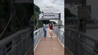
【利島】GO TO SHIMA GO TOSHIMA
ドローンで撮影した映像を主に、伊豆諸島・利島のPR動画を勝手に作成しました。
ドローンで撮影した映像を主に、伊豆諸島・利島のPR動画を勝手に作成しました。
Okinotorishima: The Most Expensive Island Dispute in History
Two tiny rocks in the middle of the Pacific—Okinotorishima—are at the ...
Two tiny rocks in the middle of the Pacific—Okinotorishima—are at the center of one of Asia's most strategic disputes.
【利島ひとり旅】Toshima island- Izu island
利島で一週間アルバイトをしながら旅してきました。利島は伊豆諸島にある小さな島で人口300人ほどと言われています。
利島で一週間アルバイトをしながら旅してきました。利島は伊豆諸島にある小さな島で人口300人ほどと言われています。
Enoshima Island: A Refreshing Day Trip from Tokyo
For a refreshing, coastal day trip close to Tokyo look no further than ...
For a refreshing, coastal day trip close to Tokyo look no further than Enoshima. A small island west of Kamakura, Enoshima's got a ...
🇯🇵 How to write ISLAND - 島 (shima) in Japanese Kanji #kanji #japanese #shorts
Welcome to Japan's Cat Island! 😻 | Travel in Japan! 🌸
MeowGical Adventures: Welcome to Japan's Cat Island! #CatIsland #Japan ...
MeowGical Adventures: Welcome to Japan's Cat Island! #CatIsland #Japan #Cats #TravelinJapan #JapanTravel ...
Military Free Fall, Ie Shima Island, Okinawa Japan
WOMEN BANNED from Japan's Sacred Ōkina-shima Island?
WOMEN BANNED from Japan's Sacred Ōkina-shima Island? #shorts #japan.
WOMEN BANNED from Japan's Sacred Ōkina-shima Island? #shorts #japan.
島 shima (island) #japan #japaneducation #asianlanguage #japaneseofisland
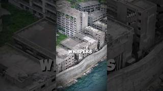
The Haunted Ghost Island of Japan 😱 | Hashima Island
Description: Hashima Island, also known as Battleship Island, hides ...
Description: Hashima Island, also known as Battleship Island, hides Japan's darkest history. Once home to 5000 forced laborers, ...
Okinotorishima: The World’s Smallest Dispute. #shorts
"In the middle of the Pacific Ocean lies a rock smaller than a tennis ...
"In the middle of the Pacific Ocean lies a rock smaller than a tennis court… yet it's at the center of a massive territorial battle ...
Awaji-shima island, the holy fortress Awaji island
The last samurai visits Awaji-shima island and introduces Izanagi ...
The last samurai visits Awaji-shima island and introduces Izanagi jingu shrine, Sumoto castle and Uzushio, the famous whirlpool ...
Japan's Cat Island - Incredible!
This is the first video of a special video series featuring Japan's ...
This is the first video of a special video series featuring Japan's Cat Island! To experience the amazing history and culture of ...
I Survived 48 Hours on Tokyo's HIDDEN Desert Island | Feat. @CDawgVA
Could YOU live on Tokyo's biggest island? @CDawgVA & I jet off for ...
Could YOU live on Tokyo's biggest island? @CDawgVA & I jet off for Wacky Weekend in the Pacific. ⭐ GRAB the Insta360 GO 3 + ...
Sarushima is the perfect destination for a hike full of nature just a day trip from Tokyo!
Uku Shima island, Uku island, Nagasaki, Japan #remoteisland
Location: Uku Shima island, located in Nagasaki prefecture, the ...
Location: Uku Shima island, located in Nagasaki prefecture, the northernmost of "Goto islands," which means "Five islands".
The Shima Shima no Mi grants Avalo Pizarro the terrifying ability to assimilate into and manipulate
OnePiece #AvaloPizarro #ShimaShimaNoMi #BlackbeardPirates #Hachinosu ...
OnePiece #AvaloPizarro #ShimaShimaNoMi #BlackbeardPirates #Hachinosu #DevilFruit #GrandLine #AnimeFacts ...
You are BANNED from this island ! ❌
Restricted Island in Japan ! #ForbiddenIsland #JapanSecrets ...
Restricted Island in Japan ! #ForbiddenIsland #JapanSecrets #GeographyFacts #Okinotorishima #PacificOceanPower ...
Japan is classified as Developed region: G7: Group of Seven – Major advanced economies, including Canada, France, Germany, Italy, Japan, the United Kingdom, and the United States. The level of income is High income: OECD.
News – Latest Updates and Headlines from To Shima
Stay informed with the most recent news and important headlines from To Shima. Here’s a roundup of the latest developments.
Loading...
Please note: The data used here has been primarily extracted from satellite readings. Deviations from exact values may occur, particularly regarding the height of elevations and population density. Land area and coastline measurements refer to average values at mean high tide.