Tokelaau
Welcome to Tokelaau, a Tropical island in the South Pacific Ocean, part of the majestic Pacific Ocean. This guide offers a comprehensive overview of what makes Tokelaau unique – from its geography and climate to its population, infrastructure, and beyond. Dive into the details:
- Geography and Size: Explore the island’s size and location.
- Climate and Weather: Weather patterns and temperature.
- Topography and Nature: Uncover the natural wonders of the island.
- Infrastructure and Travelling: Insights on reaching, staying, and making the most of your visit.
- News and Headlines: Latest News.
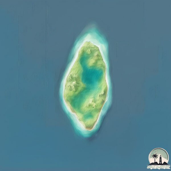
Geography and size of Tokelaau
Size: 3.093 km²
Coastline: 7.6 km
Ocean: Pacific Ocean
Sea: South Pacific Ocean
Continent: Oceania
Tokelaau is a Small Island spanning 3.1 km² with a coastline of 7.6 km.
Archipel: Polynesia – A region of more than 1,000 islands in the central and southern Pacific Ocean, known for their diverse Polynesian cultures, stunning landscapes, and marine biodiversity.
Tectonic Plate: Pacific – The world’s largest tectonic plate, covering much of the Pacific Ocean, known for the Pacific Ring of Fire with extensive seismic and volcanic activity.
The geographic heart of the island is pinpointed at these coordinates:
Latitude: -6.28790456 / Longitude: 176.32050126
Climate and weather of Tokelaau
Climate Zone: Tropical
Climate Details: Tropical Rainforest Climate
Temperature: Hot
Climate Characteristics: This climate is typified by heavy rainfall throughout the year, high humidity, and consistently high temperatures, leading to lush rainforests and rich biodiversity. Seasonal temperature variations are minimal.
Topography and nature of Tokelaau
Timezone: UTC+12:00
Timezone places: Pacific/Auckland
Max. Elevation: 13 m
Mean Elevation: 11 m
Vegetation: Mangrove Forest
Tree Coverage: 81%
The mean elevation is 11 m. The highest elevation on the island reaches approximately 13 meters above sea level. The island is characterized by Plains: Flat, low-lying lands characterized by a maximum elevation of up to 200 meters. On islands, plains are typically coastal lowlands or central flat areas.
Dominating Vegetation: Mangrove Forest
Found in coastal areas and river deltas, these unique wetland ecosystems are adapted to saline conditions and are crucial for coastal protection and biodiversity. Tokelaau has a tree cover of 81 %.
Vegetation: 7 vegetation zones – Very Highly Diverse Island
Islands in this range are ecological powerhouses, showcasing a wide array of vegetation zones. Each zone, from lush rainforests to arid scrublands, coastal mangroves to mountainous regions, contributes to a complex and interdependent ecosystem. These islands are often hotspots of biodiversity, supporting numerous species and intricate ecological processes.
Infrastructure and Travelling to Tokelaau
Does the island have a public airport? no.
There is no public and scheduled airport on Tokelaau. The nearest airport is Funafuti International Airport, located 404 km away.
Does the island have a major port? no.
There are no major ports on Tokelaau. The closest major port is FUNAFUTI ATOLL, approximately 398 km away.
The mean population of Tokelaau is 139 per km². Tokelaau is Moderately Inhabited. The island belongs to Tuvalu.
Continuing your journey, Nikunau is the next notable island, situated merely km away.
Top 10 Facts About Tokelau Island


Tuvalu is classified as Least developed region: Countries that exhibit the lowest indicators of socioeconomic development, with the lowest Human Development Index ratings. The level of income is Upper middle income.
News – Latest Updates and Headlines from Tokelaau
Stay informed with the most recent news and important headlines from Tokelaau. Here’s a roundup of the latest developments.
Please note: The data used here has been primarily extracted from satellite readings. Deviations from exact values may occur, particularly regarding the height of elevations and population density. Land area and coastline measurements refer to average values at mean high tide.