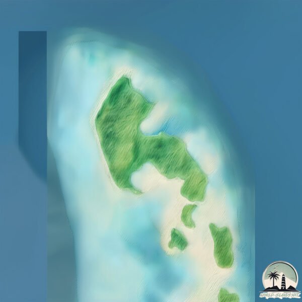
Welcome to Tokinivae, a Tropical island in the South Pacific Ocean, part of the majestic Pacific Ocean. This guide offers a comprehensive overview of what makes Tokinivae unique – from its geography and climate to its population, infrastructure, and beyond. Dive into the details:
Geography and size of Tokinivae
Size: 1.696 km²
Coastline: 9.4 km
Ocean: Pacific Ocean
Sea: South Pacific Ocean
Continent: Oceania
Tokinivae is a Small Island spanning 1.7 km² with a coastline of 9.4 km.
Archipel: Polynesia – A region of more than 1,000 islands in the central and southern Pacific Ocean, known for their diverse Polynesian cultures, stunning landscapes, and marine biodiversity.
Tectonic Plate: Sunda – Extends across Southeast Asia, encompassing parts of the Sunda Shelf, known for its interaction with the Australian Plate, contributing to volcanic activity in Indonesia.
The geographic heart of the island is pinpointed at these coordinates:
Latitude: -7.19967765 / Longitude: 177.15106818
Climate and weather of Tokinivae
Climate Zone: Tropical
Climate Details: Tropical Rainforest Climate
Temperature: Hot
Climate Characteristics: This climate is typified by heavy rainfall throughout the year, high humidity, and consistently high temperatures, leading to lush rainforests and rich biodiversity. Seasonal temperature variations are minimal.
Topography and nature of Tokinivae
Timezone: UTC+12:00
Timezone places: Pacific/Auckland
Max. Elevation: -6 m
Mean Elevation: -132 m
Vegetation: Evergreen Needleleaf Forest
Tree Coverage: 61%
The mean elevation is -132 m. Remarkably, this unique island barely emerges above the sea level, showcasing nature’s fascinating interplay with the ocean. The island is characterized by Plains: Flat, low-lying lands characterized by a maximum elevation of up to 200 meters. On islands, plains are typically coastal lowlands or central flat areas.
Dominating Vegetation: Evergreen Needleleaf Forest
Dominated by evergreen coniferous trees such as pines and firs, which retain their needle-like leaves throughout the year. These forests are often found in cooler climates. Tokinivae has a tree cover of 61 %.
Vegetation: 5 vegetation zones – Highly Diverse Island
With five different vegetation zones, these islands offer a rich tapestry of ecosystems. The variety could include dense forests, open meadows, wetlands, coastal zones, and more. This level of diversity supports an intricate web of life, with each zone playing a vital role in the overall ecological health and balance of the island.
Infrastructure and Travelling to Tokinivae
Does the island have a public airport? no.
There is no public and scheduled airport on Tokinivae. The nearest airport is Funafuti International Airport, located 269 km away.
Does the island have a major port? no.
There are no major ports on Tokinivae. The closest major port is FUNAFUTI ATOLL, approximately 263 km away.
The mean population of Tokinivae is 0 per km². Tokinivae is Uninhabited. The island belongs to Tuvalu.
Continuing your journey, Rotuma Island is the next notable island, situated merely km away.
ADB, Australia, Tuvalu Handover New Climate Resilient Boat Harbor in Nui
The Asian Development Bank, Australian Infrastructure Financing Facility for the Pacific, and the Government of Australia joined ...ADB, Australia, Tuvalu Handover New Climate Resilient Boat Harbor in Nui
The Asian Development Bank, Australian Infrastructure Financing ...
The Asian Development Bank, Australian Infrastructure Financing Facility for the Pacific, and the Government of Australia joined ...
What to visit in Tuvalu | The Most Amazing Places in Tuvalu | Tuvalu Travelvlog | Tuvalu country
Top 10 Cities to Visit in Tuvalu: Discover the Pacific Paradise! ...
Top 10 Cities to Visit in Tuvalu: Discover the Pacific Paradise! **Description:** Explore the stunning landscapes, vibrant culture, ...
Wonders of Tuvalu | The Most Amazing Places in Tuvalu | Tuvalu Travelvlog | Tuvalu country
Top 10 Cities to Visit in Tuvalu: Discover the Pacific Paradise! ...
Top 10 Cities to Visit in Tuvalu: Discover the Pacific Paradise! **Description:** Explore the stunning landscapes, vibrant culture, ...
Top 5 Must Visit Travel Destination in Tuvalu in 2024!
Discover the hidden gem of the Pacific with our guide to the top 5 ...
Discover the hidden gem of the Pacific with our guide to the top 5 must-visit spots in Tuvalu! This tiny island nation offers stunning ...
Nui: The Tranquil Emerald Isle of Tuvalu
Tuvalu Coastal Adaptation Project overview
Let's look back at Hall's work on the Tuvalu Coastal Adaptation ...
Let's look back at Hall's work on the Tuvalu Coastal Adaptation Project (TCAP)! Since commencing the project in 2022, our crew ...
Nui atoll, Tuvalu
Water resources assessment on Nui atoll, Tuvalu. Music written by ...
Water resources assessment on Nui atoll, Tuvalu. Music written by Tamaika Kofe (TK Music) ...
Outer Islands Maritime Infrastructure Project | Nui, Tuvalu
One of Tuvalu's coral atolls, Nui, depends on maritime transport for ...
One of Tuvalu's coral atolls, Nui, depends on maritime transport for food, supplies and access to essential services. To enable ...
Top 5 Spots to Visit in Nui (Tuvalu)
"Welcome to TravelBytes, your go-to destination for bite-sized travel ...
"Welcome to TravelBytes, your go-to destination for bite-sized travel tips and recommendations! Whether you're an avid traveler or ...
🌊 Tuvalu: The Most Isolated Country in the World 🏝️ Travel Vlog
Join us on an unforgettable journey to Tuvalu, one of the world's ...
Join us on an unforgettable journey to Tuvalu, one of the world's smallest and most isolated country, hidden deep in the heart of ...
Unveiling Tuvalu: Top Places to Visit
Discovering Paradise: A Journey Through Tuvalu's Hidden Gems** ...
Discovering Paradise: A Journey Through Tuvalu's Hidden Gems** Welcome, fellow travelers, to the tiny yet enchanting paradise ...
The island that is dying.
The island that is dying. In this fascinating video we present the ...
The island that is dying. In this fascinating video we present the history of Tuvalu, a small island state in the Pacific Ocean. We will ...
Islands of Tuvalu
These are the islands and atolls of the island nations Tuvalu.
These are the islands and atolls of the island nations Tuvalu.
Tuvalu
Tuvalu (/tuːˈvɑːluː/ too-VAH-loo; formerly known as the Ellice ...
Tuvalu (/tuːˈvɑːluː/ too-VAH-loo; formerly known as the Ellice Islands) is an island country in the Polynesian subregion of ...
VISIT NANUMEA, TUVALU ISLAND 🇹🇻
Nui atoll
Tuvalu all's Nui Atoll.
Tuvalu all's Nui Atoll.
"Discover Niue: The Hidden Gem of Polynesia & Its Breathtaking Wonders!"
Explore Niue – The Rock of Polynesia, one of the world's most unique ...
Explore Niue – The Rock of Polynesia, one of the world's most unique raised coral islands. From dramatic limestone cliffs and ...
TUVALU THE SMALLEST COUNTRY
uvalu is one of the smallest and most remote countries in the world, ...
uvalu is one of the smallest and most remote countries in the world, located in the west-central Pacific Ocean. The nation consists ...
Tuvalu Uncovered: The Hidden Peoples, History & Homes of a Tiny Island Nation
The most and least expensive, the craziest… Top 10 revealed. come with ...
The most and least expensive, the craziest… Top 10 revealed. come with us to uncover top 10 lists all around the globe. if you ...
Authentic Cook Islands Experience: Travel Like a Local with These Insider Tips!
TRAVEL LIKE A LOCAL IN COOK ISLANDS: TIPS FOR IMMERSIVE EXPERIENCES: ...
TRAVEL LIKE A LOCAL IN COOK ISLANDS: TIPS FOR IMMERSIVE EXPERIENCES: ...
A Glimpse of Life on a Atoll in the Middle of the South Pacific
Welcome to the Tuamotus, French Polynesia where life runs a bit slower ...
Welcome to the Tuamotus, French Polynesia where life runs a bit slower here but things always seem to get done. And it's the ...
Climate Change and Food Security: Stories from Nui Island, Tuvalu
Climate change is posing existential security threats to low-lying ...
Climate change is posing existential security threats to low-lying atoll nations. Tuvalu is planning for the worst-case scenario: the ...
Niue: The Rocky Island of Polynesia and Its Unique Self-Governing Status
Explore Niue, the small island nation in the South Pacific known as ...
Explore Niue, the small island nation in the South Pacific known as 'The Rock of Polynesia.' Discover its unique self-governing ...
Getting Food on a Tiny Atoll in the South Pacific
The supply ship has arrived and that means fresh fruit and vegetables, ...
The supply ship has arrived and that means fresh fruit and vegetables, sort of…But hey, we'll take what we can get! We're still ...
Life on a Tiny Atoll in the South Pacific
For more videos, check out @twoafloat #sailing #boatlife #diving ...
For more videos, check out @twoafloat #sailing #boatlife #diving #sailinglife #adventure #spearfishing SOCIAL: ...
Tuvalu is classified as Least developed region: Countries that exhibit the lowest indicators of socioeconomic development, with the lowest Human Development Index ratings. The level of income is Upper middle income.
News – Latest Updates and Headlines from Tokinivae
Stay informed with the most recent news and important headlines from Tokinivae. Here’s a roundup of the latest developments.
Loading...
Please note: The data used here has been primarily extracted from satellite readings. Deviations from exact values may occur, particularly regarding the height of elevations and population density. Land area and coastline measurements refer to average values at mean high tide.