To'opua
Welcome to To’opua, a Tropical island in the South Pacific Ocean, part of the majestic Pacific Ocean. This guide offers a comprehensive overview of what makes To’opua unique – from its geography and climate to its population, infrastructure, and beyond. Dive into the details:
- Geography and Size: Explore the island’s size and location.
- Climate and Weather: Weather patterns and temperature.
- Topography and Nature: Uncover the natural wonders of the island.
- Infrastructure and Travelling: Insights on reaching, staying, and making the most of your visit.
- News and Headlines: Latest News.
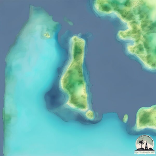
Geography and size of To’opua
Size: 1.511 km²
Coastline: 8.4 km
Ocean: Pacific Ocean
Sea: South Pacific Ocean
Continent: Oceania
To’opua is a Small Island spanning 1.5 km² with a coastline of 8.4 km.
Archipel: Society Islands – A group of islands in the South Pacific Ocean, part of French Polynesia, famous for their idyllic beauty, including Tahiti and Bora Bora.
Tectonic Plate: Pacific – The world’s largest tectonic plate, covering much of the Pacific Ocean, known for the Pacific Ring of Fire with extensive seismic and volcanic activity.
The geographic heart of the island is pinpointed at these coordinates:
Latitude: -16.51957503 / Longitude: -151.76664812
Climate and weather of To’opua
Climate Zone: Tropical
Climate Details: Tropical Rainforest Climate
Temperature: Hot
Climate Characteristics: This climate is typified by heavy rainfall throughout the year, high humidity, and consistently high temperatures, leading to lush rainforests and rich biodiversity. Seasonal temperature variations are minimal.
Topography and nature of To’opua
Timezone: UTC-10:00
Timezone places: Pacific/Honolulu
Max. Elevation: 34 m
Mean Elevation: 13 m
Vegetation: Open Woodland
Tree Coverage: 64%
The mean elevation is 13 m. The highest elevation on the island reaches approximately 34 meters above sea level. The island is characterized by Plains: Flat, low-lying lands characterized by a maximum elevation of up to 200 meters. On islands, plains are typically coastal lowlands or central flat areas.
Dominating Vegetation: Open Woodland
Characterized by sparsely distributed trees with open canopy allowing sunlight to penetrate, supporting grasses and shrubs underneath. Often found in drier or transitional environments. To’opua has a tree cover of 64 %.
Vegetation: 5 vegetation zones – Highly Diverse Island
With five different vegetation zones, these islands offer a rich tapestry of ecosystems. The variety could include dense forests, open meadows, wetlands, coastal zones, and more. This level of diversity supports an intricate web of life, with each zone playing a vital role in the overall ecological health and balance of the island.
Infrastructure and Travelling to To’opua
Does the island have a public airport? no.
There is no public and scheduled airport on To’opua. The nearest airport is Bora Bora Airport, located 7 km away.
Does the island have a major port? no.
There are no major ports on To’opua. The closest major port is VAITAPE, approximately 2 km away.
The mean population of To’opua is 314 per km². To’opua is Moderately Inhabited. The island belongs to France.
The name of the island resonates across different cultures and languages. Here is how it is known around the world: Arabic: بورا بورا; German: Bora Bora; Spanish: Bora Bora; French: Bora-Bora; Portuguese: Bora Bora; Russian: Бора-Бора; Chinese: 博拉博拉岛
Continuing your journey, Bora Bora is the next notable island, situated merely km away.
Scuba Toopua - Beginner Diver


France is classified as Developed region: G7: Group of Seven – Major advanced economies, including Canada, France, Germany, Italy, Japan, the United Kingdom, and the United States. The level of income is High income: OECD.
News – Latest Updates and Headlines from To’opua
Stay informed with the most recent news and important headlines from To’opua. Here’s a roundup of the latest developments.
- I've been to 30 tropical islands. From Bora Bora to Barbados, here are the 5 I'd definitely visit again. - MSNby "Bora Bora island" - Google News on 31 March 2026
I've been to 30 tropical islands. From Bora Bora to Barbados, here are the 5 I'd definitely visit again. MSN
- French Polynesia - Economy, Tourism, Agriculture - Britannicaby "Bora Bora island" - Google News on 25 March 2026
French Polynesia - Economy, Tourism, Agriculture Britannica
- The remote paradise islands — and the sleek way to reach them - The Timesby "Bora Bora island" - Google News on 22 March 2026
The remote paradise islands — and the sleek way to reach them The Times
- The Best Ways To Fly to Bora Bora With Points and Miles - Upgraded Pointsby "Bora Bora island" - Google News on 22 March 2026
The Best Ways To Fly to Bora Bora With Points and Miles Upgraded Points
- Catriona Rowntree goes beyond the beaches and lagoons of Bora Bora - 9Nowby "Bora Bora island" - Google News on 22 March 2026
Catriona Rowntree goes beyond the beaches and lagoons of Bora Bora 9Now
- Island dreams: What it's like to sail to French Polynesia with Windstar Cruises - World of Cruisingby "Bora Bora island" - Google News on 19 March 2026
Island dreams: What it's like to sail to French Polynesia with Windstar Cruises World of Cruising
- Miami Joins Easter Island, Cape Town, Singapore, Bora Bora, Rome, Florence, Sydney, Barcelona, Hong Kong, and More on Azamara’s Epic 2028 World Cruise, Covering 6 Continents and 40 Countries - Travel And Tour Worldby "Bora Bora island" - Google News on 13 March 2026
Miami Joins Easter Island, Cape Town, Singapore, Bora Bora, Rome, Florence, Sydney, Barcelona, Hong Kong, and More on Azamara’s Epic 2028 World Cruise, Covering 6 Continents and 40 Countries Travel And Tour World
- Bora Bora looks like a scene from Avatar, but behind the turquoise lagoon lies a 7-million-year-old sinking volcano, a growing coral reef, and extreme logistical support for 10 people isolated in the Pacific. - CPG Click Petróleo e Gásby "Bora Bora island" - Google News on 4 March 2026
Bora Bora looks like a scene from Avatar, but behind the turquoise lagoon lies a 7-million-year-old sinking volcano, a growing coral reef, and extreme logistical support for 10 people isolated in the Pacific. CPG Click Petróleo e Gás
- I've been to 30 tropical islands. From Bora Bora to Barbados, here are the 5 I'd definitely visit again. - aol.comby "Bora Bora island" - Google News on 1 March 2026
I've been to 30 tropical islands. From Bora Bora to Barbados, here are the 5 I'd definitely visit again. aol.com
- I've been to 30 tropical islands. From Bora Bora to Barbados, here are the 5 I'd definitely visit again. - Business Insider Africaby "Bora Bora island" - Google News on 27 February 2026
I've been to 30 tropical islands. From Bora Bora to Barbados, here are the 5 I'd definitely visit again. Business Insider Africa
Please note: The data used here has been primarily extracted from satellite readings. Deviations from exact values may occur, particularly regarding the height of elevations and population density. Land area and coastline measurements refer to average values at mean high tide.