Top Cay
Welcome to Top Cay, a Tropical island in the North Atlantic Ocean, part of the majestic Atlantic Ocean. This guide offers a comprehensive overview of what makes Top Cay unique – from its geography and climate to its population, infrastructure, and beyond. Dive into the details:
- Geography and Size: Explore the island’s size and location.
- Climate and Weather: Weather patterns and temperature.
- Topography and Nature: Uncover the natural wonders of the island.
- Infrastructure and Travelling: Insights on reaching, staying, and making the most of your visit.
- News and Headlines: Latest News.
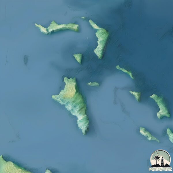
Geography and size of Top Cay
Size: 1.543 km²
Coastline: 6.3 km
Ocean: Atlantic Ocean
Sea: North Atlantic Ocean
Continent: North America
Top Cay is a Small Island spanning 1.5 km² with a coastline of 6.3 km.
Archipel: Bahama Islands – An archipelago in the Atlantic Ocean, known for their stunning beaches, coral reefs, and vibrant culture.
Tectonic Plate: North America – Covers North America and parts of the Atlantic and Arctic Oceans, characterized by diverse geological features and varying levels of seismic activity.
The geographic heart of the island is pinpointed at these coordinates:
Latitude: 26.05604012 / Longitude: -77.57653535
Climate and weather of Top Cay
Climate Zone: Tropical
Climate Details: Tropical Monsoon Climate
Temperature: Hot
Climate Characteristics: Characterized by heavy rainfall, high humidity, and uniformly high temperatures, but with a distinct short dry season. It features a seasonal reversal of prevailing wind directions.
Topography and nature of Top Cay
Timezone: UTC-05:00
Timezone places: America/New_York
Max. Elevation: 0 m
Mean Elevation: -5 m
Vegetation: Open Woodland
Tree Coverage: 60%
The mean elevation is -5 m. The highest elevation on the island reaches approximately 0 meters above sea level. The island is characterized by Plains: Flat, low-lying lands characterized by a maximum elevation of up to 200 meters. On islands, plains are typically coastal lowlands or central flat areas.
Dominating Vegetation: Open Woodland
Characterized by sparsely distributed trees with open canopy allowing sunlight to penetrate, supporting grasses and shrubs underneath. Often found in drier or transitional environments. Top Cay has a tree cover of 60 %.
Vegetation: 3 vegetation zones – Moderately Diverse Island
These islands start to show a broader range of ecological niches. With three vegetation zones, they may offer a mix of ecosystems like coastal areas, inland woods, and perhaps a distinct wetland or dry area. This diversity supports a wider range of flora and fauna, making these islands more ecologically complex than those with minimal diversity.
Infrastructure and Travelling to Top Cay
Does the island have a public airport? no.
There is no public and scheduled airport on Top Cay. The nearest airport is Congo Town Airport, located 53 km away.
Does the island have a major port? no.
There are no major ports on Top Cay. The closest major port is SOUTH RIDING POINT, approximately 82 km away.
The mean population of Top Cay is 16 per km². Top Cay is Gently Populated. The island belongs to The Bahamas.
Continuing your journey, Moore’s Island is the next notable island, situated merely km away.
30 top tips and tricks for MSC's Ocean Cay private island


The Bahamas is classified as Developing region: Regions characterized by lower income levels, with economies in the process of industrialization and modernization. The level of income is High income: nonOECD.
News – Latest Updates and Headlines from Top Cay
Stay informed with the most recent news and important headlines from Top Cay. Here’s a roundup of the latest developments.
Please note: The data used here has been primarily extracted from satellite readings. Deviations from exact values may occur, particularly regarding the height of elevations and population density. Land area and coastline measurements refer to average values at mean high tide.