Welcome to Torrens, a Dry island in the Great Australian Bight, part of the majestic Indian Ocean. This guide offers a comprehensive overview of what makes Torrens unique – from its geography and climate to its population, infrastructure, and beyond. Dive into the details:
Geography and size of Torrens
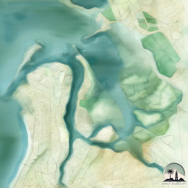
Size: 9.706 km²
Coastline: 26.8 km
Ocean: Indian Ocean
Sea: Great Australian Bight
Continent: Oceania
Torrens is a Small Island spanning 9.7 km² with a coastline of 26.8 km.
Archipel: –
Tectonic Plate: Australia – A major tectonic plate covering Australia, New Zealand, and parts of the Indian and Pacific Oceans, known for its relative stability and occasional seismic activity.
The geographic heart of the island is pinpointed at these coordinates:
Latitude: -34.78994755 / Longitude: 138.52847306
Climate and weather of Torrens
Climate Zone: Dry
Climate Details: Cold Semi-Arid (Steppe) Climate
Temperature: Cold
Climate Characteristics: Characterized by hot summers and cold winters, this climate is typically found on the edges of continental zones. It receives sufficient precipitation to avoid desert conditions.
Topography and nature of Torrens
Timezone: UTC+09:30
Timezone places: Australia/Adelaide
Max. Elevation: 6 m
Mean Elevation: 4 m
Vegetation: Mangrove Forest
Tree Coverage: 77%
The mean elevation is 4 m. The highest elevation on the island reaches approximately 6 meters above sea level. The island is characterized by Plains: Flat, low-lying lands characterized by a maximum elevation of up to 200 meters. On islands, plains are typically coastal lowlands or central flat areas.
Dominating Vegetation: Mangrove Forest
Found in coastal areas and river deltas, these unique wetland ecosystems are adapted to saline conditions and are crucial for coastal protection and biodiversity. Torrens has a tree cover of 77 %.
Vegetation: 5 vegetation zones – Highly Diverse Island
With five different vegetation zones, these islands offer a rich tapestry of ecosystems. The variety could include dense forests, open meadows, wetlands, coastal zones, and more. This level of diversity supports an intricate web of life, with each zone playing a vital role in the overall ecological health and balance of the island.
Infrastructure and Travelling to Torrens
Does the island have a public airport? no.
There is no public and scheduled airport on Torrens. The nearest airport is Adelaide International Airport, located 15 km away.
Does the island have a major port? no.
There are no major ports on Torrens. The closest major port is PORT ADELAIDE, approximately 5 km away.
The mean population of Torrens is 1 per km². Torrens is Uninhabited. The island belongs to Australia.
Continuing your journey, Hindmarsh is the next notable island, situated merely km away.
Torrens Island divided over development plans
The State Government's plans to build on Torrens Island have been criticised by groups who are concerned over the affect it will ...Torrens Island divided over development plans
The State Government's plans to build on Torrens Island have been ...
The State Government's plans to build on Torrens Island have been criticised by groups who are concerned over the affect it will ...
Torrens Island Quarantine Station Tour (Lost in South OZ)
Photo montage from 2023 tour of Torrens Island Quarantine Station. ...
Photo montage from 2023 tour of Torrens Island Quarantine Station. Lost in South OZ Website
https://lostinsouthoz.net/ Lost in ...
ADELAIDE METRO SERIES - AGL TORRENS ISLAND Power Station - Port Adelaide - South Australia
ADELAIDE METRO SERIES - AGL TORRENS ISLAND Power Station - Port ...
ADELAIDE METRO SERIES - AGL TORRENS ISLAND Power Station - Port Adelaide - South Australia. © 2018 DAVA ...
AGL to shut SA gas power station in 2026
Australia's largest energy generator AGL said it will close the ...
Australia's largest energy generator AGL said it will close the remains of its Torrens Island B gas power station in South Australia ...
ISLAND OF GHOSTS | Exploring Haunted Torrens Island Quarantine Station
islandofghosts #hauntedtorrensisland #torrensislandquarantinestation A ...
islandofghosts #hauntedtorrensisland #torrensislandquarantinestation A night on a Forbidden Island. The abandoned Torrens ...
#shorts #ShortJourney #TravelExpress Torrens Island Power Station AUSTRALIA
Torrens Island (Stack Inspection) Rope Access
AGL relied on Pinnacle to help with inspection and remediation on this ...
AGL relied on Pinnacle to help with inspection and remediation on this project. The stacks are of high profile serving the energy ...
Lightning Striking Torrens Island Power Station
Adelaide's Torrens Island power station is struck by lightning on the ...
Adelaide's Torrens Island power station is struck by lightning on the 17th December 2011, while another bolt strikes much closer ...
Power Station, Torrens Island sunrise high tide South Australia
A beautiful sunrise at high tide from near the Torrens Island Power ...
A beautiful sunrise at high tide from near the Torrens Island Power Station and Garden Island. South Australia.
Torrens island shipwrecks Adelaide.
footage take with phantom 3.
footage take with phantom 3.
Trolling Torrens Island.
Peddled all the way around Torrens Island in the search of Snook and ...
Peddled all the way around Torrens Island in the search of Snook and Salmon. One wrong turn had me stranded on the shallow ...
ADELAIDE METRO SERIES - TORRENS ISLAND - Adelaide - South Australia - 2018
ADELAIDE METRO SERIES - TORRENS ISLAND - Adelaide - South Australia - ...
ADELAIDE METRO SERIES - TORRENS ISLAND - Adelaide - South Australia - 2018. © 2018 DAVA Photography Adelaide South ...
Torrens Island Bridge. Short
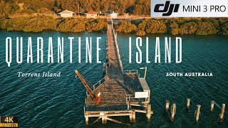
'Quarantine Island' I Torrens Island I DJI Mini 3 Pro
Torrens Island Quarantine Station was built in 1879 to stop passengers ...
Torrens Island Quarantine Station was built in 1879 to stop passengers bringing diseases such as smallpox into Adelaide. Today ...
ADELAIDE METRO SERIES - AGL POWER STATION - Torrens Island - Adelaide - South Australia - 2017
ADELAIDE METRO SERIES - AGL POWER STATION - Torrens Island - Adelaide ...
ADELAIDE METRO SERIES - AGL POWER STATION - Torrens Island - Adelaide - South Australia - 2017 © 2018 DAVA ...
TORRENS ISLAND
Testing out photo settings on a beautiful morning overlooking Torrens ...
Testing out photo settings on a beautiful morning overlooking Torrens Island, Outer Harbour and beyond.
Torrens Island South Australia
A drone view of Torrens Island in South Australia.
A drone view of Torrens Island in South Australia.
Torrens Island Quarantine Station
The Torrens Island Quarantine Station has stood in chilling isolation ...
The Torrens Island Quarantine Station has stood in chilling isolation on Torrens Island since 1880 when it was built to stop ...
GHOSTS of a Forbidden Island | Part 2 | HAUNTED Torrens Island Quarantine Station
islandofghosts #hauntedtorrensisland #torrensislandquarantinestation A ...
islandofghosts #hauntedtorrensisland #torrensislandquarantinestation A night on a Forbidden Island. The abandoned Torrens ...
AGL to close Torrens Island ‘B’ Power Station #shortvideo #youtubeshorts #shorts
AGL to close Torrens Island 'B' Power Station #shortvideo ...
AGL to close Torrens Island 'B' Power Station #shortvideo #youtubeshorts #shorts AGL Energy has today announced it will close ...
Torrens Island - South Australia - Drone Footage 1080P
Views of Torrens Island & the Port River - South Australia - ...
Torrens Island Power Station to Quarantine Station (1854) | Part 1
In this first part of our journey to the Torrens Island Quarantine ...
In this first part of our journey to the Torrens Island Quarantine Station (est. 1854), we pass through the Torrens Island Power ...
Historical Torrens Island Quarantine Station - Linen Store
Torrens Island Quarantine Station first opened as a tent city in 1855. ...
Torrens Island Quarantine Station first opened as a tent city in 1855. Later the buildings were constructed, including a doctors ...
Historical Torrens Island Quarantine Station. - Laundry
Torrens Island Quarantine Station first opened as a tent city in 1855. ...
Torrens Island Quarantine Station first opened as a tent city in 1855. Later the buildings were constructed, including a doctors ...
Australia is classified as Developed region: nonG7: Developed economies outside of the Group of Seven, characterized by high income and advanced economic structures. The level of income is High income: OECD.
News – Latest Updates and Headlines from Torrens
Stay informed with the most recent news and important headlines from Torrens. Here’s a roundup of the latest developments.
Loading...
Please note: The data used here has been primarily extracted from satellite readings. Deviations from exact values may occur, particularly regarding the height of elevations and population density. Land area and coastline measurements refer to average values at mean high tide.