Towagery Island
Welcome to Towagery Island, a Dry island in the Great Australian Bight, part of the majestic Indian Ocean. This guide offers a comprehensive overview of what makes Towagery Island unique – from its geography and climate to its population, infrastructure, and beyond. Dive into the details:
- Geography and Size: Explore the island’s size and location.
- Climate and Weather: Weather patterns and temperature.
- Topography and Nature: Uncover the natural wonders of the island.
- Infrastructure and Travelling: Insights on reaching, staying, and making the most of your visit.
- News and Headlines: Latest News.
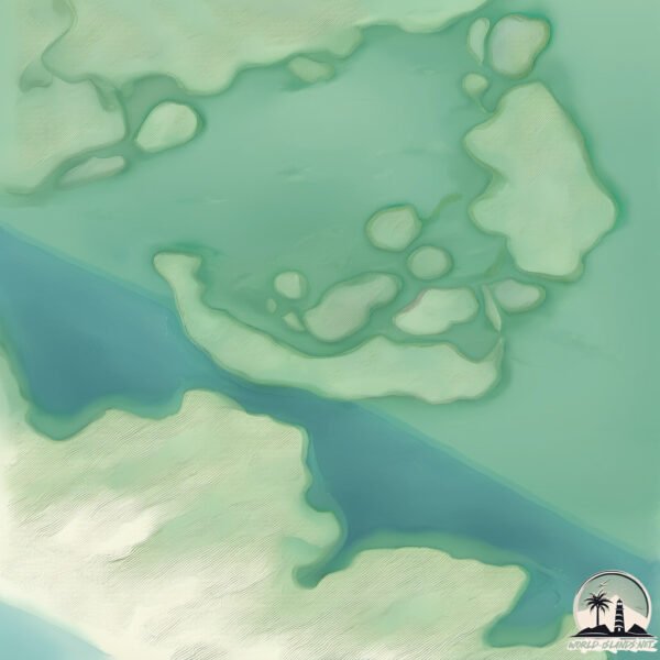
Geography and size of Towagery Island
Size: 1.581 km²
Coastline: 8.3 km
Ocean: Indian Ocean
Sea: Great Australian Bight
Continent: Oceania
Towagery Island is a Small Island spanning 1.6 km² with a coastline of 8.3 km.
Archipel: –
Tectonic Plate: Africa – One of the world’s largest tectonic plates, covering the African continent and parts of the surrounding oceans, known for its stability with some active rift zones.
The geographic heart of the island is pinpointed at these coordinates:
Latitude: -35.57336193 / Longitude: 138.99043662
Climate and weather of Towagery Island
Climate Zone: Dry
Climate Details: Cold Semi-Arid (Steppe) Climate
Temperature: Cold
Climate Characteristics: Characterized by hot summers and cold winters, this climate is typically found on the edges of continental zones. It receives sufficient precipitation to avoid desert conditions.
Topography and nature of Towagery Island
Timezone: UTC+09:30
Timezone places: Australia/Adelaide
Max. Elevation: 2 m
Mean Elevation: 1 m
Vegetation: Wetland
Tree Coverage: 80%
The mean elevation is 1 m. The highest elevation on the island reaches approximately 2 meters above sea level. The island is characterized by Plains: Flat, low-lying lands characterized by a maximum elevation of up to 200 meters. On islands, plains are typically coastal lowlands or central flat areas.
Dominating Vegetation: Wetland
These areas are saturated with water, either permanently or seasonally, and support aquatic plants. Wetlands are important for biodiversity and water filtration. Towagery Island has a tree cover of 80 %.
Vegetation: 4 vegetation zones – Diverse Island
Four distinct vegetation zones mark these islands as ecologically diverse. They might feature varied landscapes such as forests, beaches, grasslands, and rocky areas. Such diversity reflects the island’s complex ecological interactions and varied habitats, which can support a rich array of wildlife and plant species.
Infrastructure and Travelling to Towagery Island
Does the island have a public airport? no.
There is no public and scheduled airport on Towagery Island. The nearest airport is Adelaide International Airport, located 84 km away.
Does the island have a major port? no.
There are no major ports on Towagery Island. The closest major port is PORT ADELAIDE, approximately 95 km away.
The mean population of Towagery Island is 0 per km². Towagery Island is Uninhabited. The island belongs to Australia.
Continuing your journey, Mundoo is the next notable island, situated merely km away.
Come with us to Tangier Island 🏝️ #tangierisland #tangier #rvlife


Australia is classified as Developed region: nonG7: Developed economies outside of the Group of Seven, characterized by high income and advanced economic structures. The level of income is High income: OECD.
News – Latest Updates and Headlines from Towagery Island
Stay informed with the most recent news and important headlines from Towagery Island. Here’s a roundup of the latest developments.
Please note: The data used here has been primarily extracted from satellite readings. Deviations from exact values may occur, particularly regarding the height of elevations and population density. Land area and coastline measurements refer to average values at mean high tide.