Trinidad
Welcome to Trinidad, a Dry island in the South Atlantic Ocean, part of the majestic Atlantic Ocean. This guide offers a comprehensive overview of what makes Trinidad unique – from its geography and climate to its population, infrastructure, and beyond. Dive into the details:
- Geography and Size: Explore the island’s size and location.
- Climate and Weather: Weather patterns and temperature.
- Topography and Nature: Uncover the natural wonders of the island.
- Infrastructure and Travelling: Insights on reaching, staying, and making the most of your visit.
- News and Headlines: Latest News.
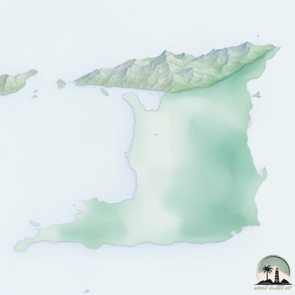
Geography and size of Trinidad
Size: 2.981 km²
Coastline: 10.1 km
Ocean: Atlantic Ocean
Sea: South Atlantic Ocean
Continent: South America
Trinidad is a Small Island spanning 3 km² with a coastline of 10.1 km.
Archipel: –
Tectonic Plate: South America – A major plate covering the South American continent and part of the Atlantic Ocean, known for the Andes mountain range and significant seismic and volcanic activity.
The geographic heart of the island is pinpointed at these coordinates:
Latitude: -39.14177936 / Longitude: -61.8873549
Climate and weather of Trinidad
Climate Zone: Dry
Climate Details: Cold Semi-Arid (Steppe) Climate
Temperature: Cold
Climate Characteristics: Characterized by hot summers and cold winters, this climate is typically found on the edges of continental zones. It receives sufficient precipitation to avoid desert conditions.
Topography and nature of Trinidad
Timezone: UTC-03:00
Timezone places: America/Sao_Paulo
Max. Elevation: 3 m
Mean Elevation: 2 m
Vegetation: Wetland
Tree Coverage: 84%
The mean elevation is 2 m. The highest elevation on the island reaches approximately 3 meters above sea level. The island is characterized by Plains: Flat, low-lying lands characterized by a maximum elevation of up to 200 meters. On islands, plains are typically coastal lowlands or central flat areas.
Dominating Vegetation: Wetland
These areas are saturated with water, either permanently or seasonally, and support aquatic plants. Wetlands are important for biodiversity and water filtration. Trinidad has a tree cover of 84 %.
Vegetation: 3 vegetation zones – Moderately Diverse Island
These islands start to show a broader range of ecological niches. With three vegetation zones, they may offer a mix of ecosystems like coastal areas, inland woods, and perhaps a distinct wetland or dry area. This diversity supports a wider range of flora and fauna, making these islands more ecologically complex than those with minimal diversity.
Infrastructure and Travelling to Trinidad
Does the island have a public airport? no.
There is no public and scheduled airport on Trinidad. The nearest airport is Comandante Espora Airport, located 51 km away.
Does the island have a major port? no.
There are no major ports on Trinidad. The closest major port is PUERTO ROSALES, approximately 26 km away.
The mean population of Trinidad is 3 per km². Trinidad is Gently Populated. The island belongs to Argentina.
Continuing your journey, Isla Trinidad is the next notable island, situated merely km away.
11 BEST Things to Do in Trinidad and Tobago | Ultimate Bucket List Attractions! MUST SEE Places.


Argentina is classified as Emerging region: G20: Group of Twenty – Major economies comprising both developed and emerging countries, representing the world’s largest economies. The level of income is Upper middle income.
News – Latest Updates and Headlines from Trinidad
Stay informed with the most recent news and important headlines from Trinidad. Here’s a roundup of the latest developments.
Please note: The data used here has been primarily extracted from satellite readings. Deviations from exact values may occur, particularly regarding the height of elevations and population density. Land area and coastline measurements refer to average values at mean high tide.