Tsalui
Welcome to Tsalui, a Tropical island in the South Pacific Ocean, part of the majestic Pacific Ocean. This guide offers a comprehensive overview of what makes Tsalui unique – from its geography and climate to its population, infrastructure, and beyond. Dive into the details:
- Geography and Size: Explore the island’s size and location.
- Climate and Weather: Weather patterns and temperature.
- Topography and Nature: Uncover the natural wonders of the island.
- Infrastructure and Travelling: Insights on reaching, staying, and making the most of your visit.
- News and Headlines: Latest News.
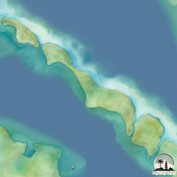
Geography and size of Tsalui
Size: 5.085 km²
Coastline: 16.3 km
Ocean: Pacific Ocean
Sea: South Pacific Ocean
Continent: Oceania
Tsalui is a Small Island spanning 5.1 km² with a coastline of 16.3 km.
Archipel: Melanesia – A subregion of Oceania in the southwestern Pacific Ocean, including countries like Fiji, Solomon Islands, and Vanuatu, known for their diverse cultures and languages.
Tectonic Plate: Sunda – Extends across Southeast Asia, encompassing parts of the Sunda Shelf, known for its interaction with the Australian Plate, contributing to volcanic activity in Indonesia.
The geographic heart of the island is pinpointed at these coordinates:
Latitude: -2.44642767 / Longitude: 150.45889115
Climate and weather of Tsalui
Climate Zone: Tropical
Climate Details: Tropical Rainforest Climate
Temperature: Hot
Climate Characteristics: This climate is typified by heavy rainfall throughout the year, high humidity, and consistently high temperatures, leading to lush rainforests and rich biodiversity. Seasonal temperature variations are minimal.
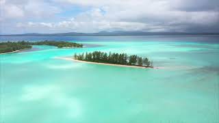
Topography and nature of Tsalui
Timezone: UTC+10:00
Timezone places: Australia/Sydney
Max. Elevation: 9 m
Mean Elevation: 7 m
Vegetation: Agricultural Mosaic
Tree Coverage: 69%
The mean elevation is 7 m. The highest elevation on the island reaches approximately 9 meters above sea level. The island is characterized by Plains: Flat, low-lying lands characterized by a maximum elevation of up to 200 meters. On islands, plains are typically coastal lowlands or central flat areas.
Dominating Vegetation: Agricultural Mosaic
A mix of cropland and natural vegetation, often seen in rural landscapes where agricultural fields are interspersed with patches of natural habitats. Tsalui has a tree cover of 69 %.
Vegetation: 9 vegetation zones – Very Highly Diverse Island
Islands in this range are ecological powerhouses, showcasing a wide array of vegetation zones. Each zone, from lush rainforests to arid scrublands, coastal mangroves to mountainous regions, contributes to a complex and interdependent ecosystem. These islands are often hotspots of biodiversity, supporting numerous species and intricate ecological processes.
Infrastructure and Travelling to Tsalui
Does the island have a public airport? no.
There is no public and scheduled airport on Tsalui. The nearest airport is Kavieng Airport, located 39 km away.
Does the island have a major port? no.
There are no major ports on Tsalui. The closest major port is KAVIENG HARBOR, approximately 38 km away.
The mean population of Tsalui is 28 per km². Tsalui is Gently Populated. The island belongs to Papua New Guinea.
Continuing your journey, Kawulikiau is the next notable island, situated merely km away.
Escape to Paradise: Exploring the Tsoilik Islands in Papua New Guinea


Papua New Guinea is classified as Developing region: Regions characterized by lower income levels, with economies in the process of industrialization and modernization. The level of income is Lower middle income.
News – Latest Updates and Headlines from Tsalui
Stay informed with the most recent news and important headlines from Tsalui. Here’s a roundup of the latest developments.
Please note: The data used here has been primarily extracted from satellite readings. Deviations from exact values may occur, particularly regarding the height of elevations and population density. Land area and coastline measurements refer to average values at mean high tide.