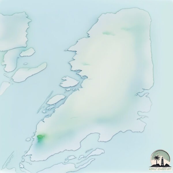
Welcome to Tukarak Island, a Polar island in the Hudson Bay, part of the majestic Arctic Ocean. This guide offers a comprehensive overview of what makes Tukarak Island unique – from its geography and climate to its population, infrastructure, and beyond. Dive into the details:
Geography and size of Tukarak Island
Size: 348.2 km²
Coastline: 207.2 km
Ocean: Arctic Ocean
Sea: Hudson Bay
Continent: North America
Tukarak Island is a Large Island spanning 348 km² with a coastline of 207 km.
Archipel: Belcher Islands – A group of islands in Canada’s Hudson Bay, known for their remote location and unique Inuit culture.
Tectonic Plate: North America – Covers North America and parts of the Atlantic and Arctic Oceans, characterized by diverse geological features and varying levels of seismic activity.
The geographic heart of the island is pinpointed at these coordinates:
Latitude: 56.26967834 / Longitude: -78.75935588
Climate and weather of Tukarak Island
Climate Zone: Polar
Climate Details: Tundra
Temperature: Cold
Climate Characteristics: The tundra climate features long, extremely cold winters and short, cool summers. Vegetation is limited to mosses, lichens, and small shrubs due to the low temperatures and short growing seasons. Biodiversity is low, but some specialized species thrive.
Topography and nature of Tukarak Island
Timezone: UTC-05:00
Timezone places: America/New_York
Max. Elevation: 146 m
Mean Elevation: 44 m
Vegetation: Herbaceous Cover
Tree Coverage: 20%
The mean elevation is 44 m. The highest elevation on the island reaches approximately 146 meters above sea level. The island is characterized by Plains: Flat, low-lying lands characterized by a maximum elevation of up to 200 meters. On islands, plains are typically coastal lowlands or central flat areas.
Dominating Vegetation: Herbaceous Cover
Comprising mainly of grasses, herbs, and ferns, these areas are common in prairies, meadows, and savannas, and can vary widely in species composition. Tukarak Island has a tree cover of 20 %.
Vegetation: 7 vegetation zones – Very Highly Diverse Island
Islands in this range are ecological powerhouses, showcasing a wide array of vegetation zones. Each zone, from lush rainforests to arid scrublands, coastal mangroves to mountainous regions, contributes to a complex and interdependent ecosystem. These islands are often hotspots of biodiversity, supporting numerous species and intricate ecological processes.
Infrastructure and Travelling to Tukarak Island
Does the island have a public airport? no.
There is no public and scheduled airport on Tukarak Island. The nearest airport is Sanikiluaq Airport, located 50 km away.
Does the island have a major port? no.
There are no major ports on Tukarak Island. The closest major port is MICHIPICOTEN, approximately 1120 km away.
The mean population of Tukarak Island is 0 per km². Tukarak Island is Uninhabited. The island belongs to Canada.
Continuing your journey, Mavor Island is the next notable island, situated merely km away.
Belcher Islands on GeoGuessr 🇨🇦❄️ #shorts
Hit the like button if you enjoyed the video. ➜ If you didn't, feel free to leave a dislike. ➜ Post a comment down below.Belcher Islands on GeoGuessr 🇨🇦❄️ #shorts
Hit the like button if you enjoyed the video. ➜ If you didn't, feel ...
Hit the like button if you enjoyed the video. ➜ If you didn't, feel free to leave a dislike. ➜ Post a comment down below.
The Beautiful Belcher Islands in Canada
A video about the Belcher Islands, so remote but so strange. Maps made ...
A video about the Belcher Islands, so remote but so strange. Maps made with Sentinel 2 Satellite Data, and SRTM Topographic ...
The Chilling Mystery of Belcher Island A 1940 Tragedy
In 1940, a remote island in Nunavut became the site of a haunting ...
In 1940, a remote island in Nunavut became the site of a haunting mystery that forever changed its small Inuit community.
The Ancient Belcher Islands: A Rugged Arctic Archipelago
Spanning 13000 square kilometers in southeastern Hudson Bay, the ...
Spanning 13000 square kilometers in southeastern Hudson Bay, the Belcher Islands form a striking yet remote Arctic landscape.
Belcher Islands Raised Beaches
A short video to show something of the raised beaches of the Belcher ...
A short video to show something of the raised beaches of the Belcher Islands, which are part of Nunavut, Canada, and are located ...
KD6WW/VY0 K9AJ/VY0 Flaherty Island Belcher Islands. From dxnews.com
KD6WW and K9AJ will be active from Flaherty Island, Belcher Islands, ...
KD6WW and K9AJ will be active from Flaherty Island, Belcher Islands, IOTA NA - 159, 26 - 29 August 2016 as KD6WW/VY0 and ...
Hudson Bay’s Oddly Shaped Island Archipelago | Canada's Strangest Islands: Part 2 | Belcher Islands
In this video we talk about the Belcher Islands, including its unique ...
In this video we talk about the Belcher Islands, including its unique geography, and grisly history, on this edition of Canada's ...
Settlements on the Belcher Islands
A short video about how the population and settlements of the Belcher ...
A short video about how the population and settlements of the Belcher Islands have changed in recent times. TIMESTAMPS 0:00 ...
How did these Islands Fold?
In this video I investigate the Geology/Geography of the Belcher ...
In this video I investigate the Geology/Geography of the Belcher Islands, a very interesting archipelago in the Hudson Bay.
Eskimo Formation
The Eskimo Formation in the Belcher islands, Nunavut, is approximately ...
The Eskimo Formation in the Belcher islands, Nunavut, is approximately 1.96 billion years old, a series of volcanic rocks, ...
Flaherty Island " in Sanikiluaq in Nunavut, Canada
Plateau of the rocky island in the water surface " Flaherty Island " ...
Plateau of the rocky island in the water surface " Flaherty Island " in Sanikiluaq in Nunavut, Canada. // Plateau der Felseninsel in ...
Dark Devotion: Tragedy and Murder in Remote Belcher Islands | Documentary
The Dark Legacy of the Belcher Islands: Unveiling a Tale of Tragedy ...
The Dark Legacy of the Belcher Islands: Unveiling a Tale of Tragedy and Fanaticism Immerse yourself in the chilling narrative of ...
Murder Under the Northern Lights: The Belcher Islands Massacre
Murder Under the Northern Lights: The Belcher Islands Massacre.
Murder Under the Northern Lights: The Belcher Islands Massacre.
The Belcher Islands Massacre | Solved
Hi everyone and welcome back to another Dammmn Canada video. todays ...
Hi everyone and welcome back to another Dammmn Canada video. todays video is covering the unfortunate events that ...
The Belcher Islands Massacre
Canadian true crime.
Canadian true crime.
Falling Stars: The Belcher Island Murders
Episode 233: During the harsh winter of 1941, as World War II raged ...
Episode 233: During the harsh winter of 1941, as World War II raged elsewhere, closer to home, a tragedy occurred on the remote ...
Charlie Ouyerack & Peter Sala : The Belcher Islands Massacre
After Christianity was brought to the Inuit people of the Belcher ...
After Christianity was brought to the Inuit people of the Belcher Islands, Charlie Ouyerack & Peter Sala proclaimed themselves as ...
The Belcher Islands Massacre
The winter of 1941 was a strange one in the remote Belcher Islands—and ...
The winter of 1941 was a strange one in the remote Belcher Islands—and that was before nine people were killed in a panic ...
Nunavut Community: Sanikiluaq (Belcher Islands) #Inuit #Facts #Inuktitut #WordOfTheDay #Nunavut
Qikiqtait: Progress on a Community-driven protected area for the Belcher Islands Archipelago
Presented by ArcticNet 2020. Contributors Mick Appaqaq, Johnny ...
Presented by ArcticNet 2020. Contributors Mick Appaqaq, Johnny Kudluarok, Emily Kattuk, Johnnie Kuki, Joel Heath and ...
Belcher Island Murders, Hudson Bay (Ep-38)
The content in this video is either owned by [owner] and used under ...
The content in this video is either owned by [owner] and used under fair use. All rights to the content, including but not limited to ...
Nature Exploration | Travel Discovered | Train and Belcher Islands Python #shorts #jungle #river
Nature Exploration | Travel Discovered | Train and Belcher Islands ...
Nature Exploration | Travel Discovered | Train and Belcher Islands Python #shorts #jungle #river #shorts #jungle #river #shorts ...
Charlie Takatak, Sharing Knowledge - Sanikiluaq
Charlie Takatak takes viewers on a trip to harvest mussels on the ...
Charlie Takatak takes viewers on a trip to harvest mussels on the Belcher Islands in Hudson's Bay in negative 50 degrees and ...
Canada is classified as Developed region: G7: Group of Seven – Major advanced economies, including Canada, France, Germany, Italy, Japan, the United Kingdom, and the United States. The level of income is High income: OECD.
News – Latest Updates and Headlines from Tukarak Island
Stay informed with the most recent news and important headlines from Tukarak Island. Here’s a roundup of the latest developments.
Loading...
Please note: The data used here has been primarily extracted from satellite readings. Deviations from exact values may occur, particularly regarding the height of elevations and population density. Land area and coastline measurements refer to average values at mean high tide.