Tundu
Welcome to Tundu, a Tropical island in the Java Sea, part of the majestic Pacific Ocean. This guide offers a comprehensive overview of what makes Tundu unique – from its geography and climate to its population, infrastructure, and beyond. Dive into the details:
- Geography and Size: Explore the island’s size and location.
- Climate and Weather: Weather patterns and temperature.
- Topography and Nature: Uncover the natural wonders of the island.
- Infrastructure and Travelling: Insights on reaching, staying, and making the most of your visit.
- News and Headlines: Latest News.
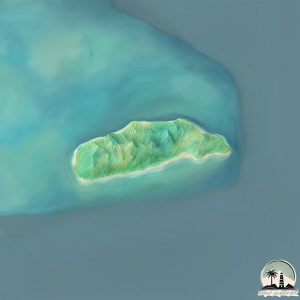
Geography and size of Tundu
Size: 2.633 km²
Coastline: 7.7 km
Ocean: Pacific Ocean
Sea: Java Sea
Continent: Asia
Tundu is a Small Island spanning 2.6 km² with a coastline of 7.7 km.
Archipel: Greater Sunda Islands – A group of large islands in Southeast Asia, including Borneo, Sumatra, Java, and Sulawesi, known for their rich biodiversity and cultural diversity.
Tectonic Plate: Australia – A major tectonic plate covering Australia, New Zealand, and parts of the Indian and Pacific Oceans, known for its relative stability and occasional seismic activity.
The geographic heart of the island is pinpointed at these coordinates:
Latitude: -7.16349667 / Longitude: 114.66940127
Climate and weather of Tundu
Climate Zone: Tropical
Climate Details: Tropical Savanna, Wet
Temperature: Hot
Climate Characteristics: Defined by distinct wet and dry seasons with high temperatures year-round. Pronounced rainfall occurs during the wet season, while the dry season is marked by drought.
Topography and nature of Tundu
Timezone: UTC+07:00
Timezone places: Asia/Jakarta
Max. Elevation: 15 m
Mean Elevation: 10 m
Vegetation: Agricultural Mosaic
Tree Coverage: 87%
The mean elevation is 10 m. The highest elevation on the island reaches approximately 15 meters above sea level. The island is characterized by Plains: Flat, low-lying lands characterized by a maximum elevation of up to 200 meters. On islands, plains are typically coastal lowlands or central flat areas.
Dominating Vegetation: Agricultural Mosaic
A mix of cropland and natural vegetation, often seen in rural landscapes where agricultural fields are interspersed with patches of natural habitats. Tundu has a tree cover of 87 %.
Vegetation: 4 vegetation zones – Diverse Island
Four distinct vegetation zones mark these islands as ecologically diverse. They might feature varied landscapes such as forests, beaches, grasslands, and rocky areas. Such diversity reflects the island’s complex ecological interactions and varied habitats, which can support a rich array of wildlife and plant species.
Infrastructure and Travelling to Tundu
Does the island have a public airport? no.
There is no public and scheduled airport on Tundu. The nearest airport is Letkol Wisnu Airstrip, located 108 km away.
Does the island have a major port? no.
There are no major ports on Tundu. The closest major port is PANARUKAN, approximately 100 km away.
The mean population of Tundu is 522 per km². Tundu is Densely Populated. The island belongs to Indonesia.
Continuing your journey, Pulau Raas is the next notable island, situated merely km away.
TUNDO: ISLA PUTING BATO | Full Movie (4K) | Fernando Poe Jr., Charito Solis


![[4K] SARDINIA 🇮🇹 Sardegna Drone Aerial, The Miracle Island of Italy | 4 Hour Ambient Relaxation Film](https://i.ytimg.com/vi/KpCVQcSqB0Q/mqdefault.jpg)

Indonesia is classified as Emerging region: MIKT: Mexico, Indonesia, South Korea, and Turkey – Economies recognized for their development potential and emerging market status. The level of income is Lower middle income.
News – Latest Updates and Headlines from Tundu
Stay informed with the most recent news and important headlines from Tundu. Here’s a roundup of the latest developments.
Please note: The data used here has been primarily extracted from satellite readings. Deviations from exact values may occur, particularly regarding the height of elevations and population density. Land area and coastline measurements refer to average values at mean high tide.