Welcome to Turkey, a Temperate island in the North Atlantic Ocean, part of the majestic Atlantic Ocean. This guide offers a comprehensive overview of what makes Turkey unique – from its geography and climate to its population, infrastructure, and beyond. Dive into the details:
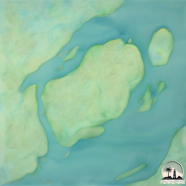
Geography and size of Turkey
Size: 5.121 km²
Coastline: 11.6 km
Ocean: Atlantic Ocean
Sea: North Atlantic Ocean
Continent: North America
Turkey is a Small Island spanning 5.1 km² with a coastline of 11.6 km.
Archipel: –
Tectonic Plate: North America – Covers North America and parts of the Atlantic and Arctic Oceans, characterized by diverse geological features and varying levels of seismic activity.
The geographic heart of the island is pinpointed at these coordinates:
Latitude: 37.36527438 / Longitude: -77.25879729
Climate and weather of Turkey
Climate Zone: Temperate
Climate Details: Humid Subtropical Climate
Temperature: Hot Summer
Climate Characteristics: With continuous rainfall and hot summers, this climate is common in some coastal regions, supporting diverse vegetation.
Topography and nature of Turkey
Timezone: UTC-05:00
Timezone places: America/New_York
Max. Elevation: 3 m
Mean Elevation: 2 m
Vegetation: Deciduous Broadleaf Forest
Tree Coverage: 37%
The mean elevation is 2 m. The highest elevation on the island reaches approximately 3 meters above sea level. The island is characterized by Plains: Flat, low-lying lands characterized by a maximum elevation of up to 200 meters. On islands, plains are typically coastal lowlands or central flat areas.
Dominating Vegetation: Deciduous Broadleaf Forest
Composed of broadleaf trees that shed their leaves seasonally. These forests are commonly found in temperate zones and experience distinct seasonal changes. Turkey has a tree cover of 37 %.
Vegetation: 7 vegetation zones – Very Highly Diverse Island
Islands in this range are ecological powerhouses, showcasing a wide array of vegetation zones. Each zone, from lush rainforests to arid scrublands, coastal mangroves to mountainous regions, contributes to a complex and interdependent ecosystem. These islands are often hotspots of biodiversity, supporting numerous species and intricate ecological processes.
Infrastructure and Travelling to Turkey
Does the island have a public airport? no.
There is no public and scheduled airport on Turkey. The nearest airport is Richmond International Airport, located 15 km away.
Does the island have a major port? no.
There are no major ports on Turkey. The closest major port is WARWICK, approximately 19 km away.
The mean population of Turkey is 0 per km². Turkey is Uninhabited. The island belongs to United States of America.
Continuing your journey, Mockhorn is the next notable island, situated merely km away.
🇹🇷 Alanya Boat Trips | Türkiye🌴
Alanya Boat Trips offers a unique experience for those who want to have an unforgettable sea adventure in the turquoise waters ...🇹🇷 Alanya Boat Trips | Türkiye🌴
Alanya Boat Trips offers a unique experience for those who want to ...
Alanya Boat Trips offers a unique experience for those who want to have an unforgettable sea adventure in the turquoise waters ...
Turkey's island of 400 ancient shipwrecks | The SpeciaList | BBC
From the island of Kekova, off the southern coast of Turkey, renowned ...
From the island of Kekova, off the southern coast of Turkey, renowned underwater archaeologist Hakan Öniz takes viewers on a ...
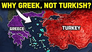
Why Turks lost the Aegean Islands
The Aegean Islands, a cluster of strategically significant islands ...
The Aegean Islands, a cluster of strategically significant islands nestled between the Anatolian coast and mainland Greece were ...
🇹🇷 Istanbul Turkey Büyükada Island #excitingtourism #travel #walk #büyükada #islandlife #paradise
Büyükada Istanbul - Turkey's Hidden Paradise in Princes' Islands Join ...
Büyükada Istanbul - Turkey's Hidden Paradise in Princes' Islands Join us as we explore the largest and most popular of the ...
TOP 10 Places in the TURKISH RIVIERA | Turkey Travel Video
Discover Our Top Hotel Recommendations and Save Up to 40% Off 2M+ ...
Discover Our Top Hotel Recommendations and Save Up to 40% Off 2M+ Hotels Worldwide When You Sign Up for Free on ...
Hidden Paradise of Turkey: Cleopatra Island
Crystal-clear waters and golden sands — Cleopatra Island in Akyaka, ...
Crystal-clear waters and golden sands — Cleopatra Island in Akyaka, Muğla is a true hidden gem! Legend says even Cleopatra ...
Suluada Island (Maldives of Turkey) 🏝️ 🇹🇷 #turkey #travelvlog #summer #nostalgia #travel #island
At the end of my travel in Turkey. I decided to visited the famous « ...
At the end of my travel in Turkey. I decided to visited the famous « Suluada Island ». Not far from Antalya. This place was so ...
Top 5 things to do in Cappadocia, Turkey 🇹🇷 #cappadocia #turkey #🇹🇷
Wonders of Turkish Islands | The Most Amazing Places in Turkey’s Islands | Travel Video 4K
Wonders of Turkish Islands | The Most Amazing Places in Turkey's ...
Wonders of Turkish Islands | The Most Amazing Places in Turkey's Islands | Travel Video 4K Subscribe to the channel here, ...
How to Visit the Princes' Islands from Istanbul
If you're in Istanbul, and the weather's nice, consider taking the ...
If you're in Istanbul, and the weather's nice, consider taking the ferry from city out to the Princes' Islands. They've long been ...
Ten Most Popular Islands of Turkey | The Best Islands In Turkey | Tourism
Ten Most Popular Islands of Turkey | The Best Islands In Turkey | ...
Ten Most Popular Islands of Turkey | The Best Islands In Turkey | Tourism In recent years, Turkey has been a popular tourism ...
How ISTANBUL might Turn into An ISLAND #shorts
How ISTANBUL might Turn into An ISLAND #shorts #geography ...
How ISTANBUL might Turn into An ISLAND #shorts #geography #geographyfacts #turkey #istanbul #istanbulturkey ...
🇹🇷 Istanbul Turkey Büyükada Island #excitingtourism #travel #walk #büyükada #islandlife #paradise
Büyükada Istanbul - Turkey's Hidden Paradise in Princes' Islands Join ...
Büyükada Istanbul - Turkey's Hidden Paradise in Princes' Islands Join us as we explore the largest and most popular of the ...
A day in Princes Island 🏝 İstanbul Turkey 🇹🇷 #büyükada #istanbul #travelvlog #youtuber #explore
KAS, TURKEY | Best Things To Do In Beautiful Kaş
Kaş is a beautiful seaside town on the Mediterranean coast of Turkey. ...
Kaş is a beautiful seaside town on the Mediterranean coast of Turkey. We stayed there for about a week and in this video, we ...
THINGS TO DO IN ANTALYA, TURKEY 🇹🇷
For more brilliant holidays at unbeatable prices check out the easyJet ...
For more brilliant holidays at unbeatable prices check out the easyJet holidays website:
https://cli.re/ejholidays @lifebymarg: ...
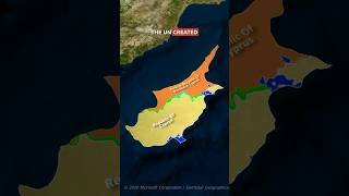
Who Really Owns Cyprus ??🔥 #shorts #maps #cyprus #geography #turkey #facts #politics #knowledge
shorts #geography #cyprus #turkey #educational #UN #greece #maps ...
shorts #geography #cyprus #turkey #educational #UN #greece #maps #border #politics #geopolitics #mediterranean #british ...
Walking on Heybeliada Island in turkey country 😍🏝 #walking #turkey #island #shorts #travel
hi guys , we came to heybeliada island in turkey . its amazing with ...
hi guys , we came to heybeliada island in turkey . its amazing with blue sky #seethecities #walking #island #travel #shorts.
Why Turkey is Transforming Istanbul Into an Island
Watch this video ad-free on Nebula: ...
Turkey island tourist must visit this place #turkey #touristdestinations #island
Most popular Islands of Turkey: A Traveler's Guide to Paradise
Most popular Islands of Turkey: A Traveler's Guide to Paradise Turkey, ...
Most popular Islands of Turkey: A Traveler's Guide to Paradise Turkey, nestled between Europe and Asia, is a land of ...
Why Istanbul Will Become An Island ?? 🔥🇹🇷 #shorts #geography #maps #turkey
shorts #maps #country #geography #turkey #türkiye #istanbul #bosporus ...
shorts #maps #country #geography #turkey #türkiye #istanbul #bosporus #istanbulcanal #canal #facts #interestingfacts #europe ...
Turkey Island 4K - Explore The Mesmerizing Istanbul Drone Videos With Relaxing Piano Music
Turkey Island 4K - Explore The Mesmerizing Istanbul Drone Videos With ...
Turkey Island 4K - Explore The Mesmerizing Istanbul Drone Videos With Relaxing Piano Music Turkey, officially the Republic of ...
Istanbul’s Calm Escape: The Princess Islands
Most visitors never make it this far from the city. The Princess ...
Most visitors never make it this far from the city. The Princess Islands sit just off Istanbul's coast, but once the ferry leaves, ...
Beautiful streets on a Turkey island 🏝️ #shorts
tiktok #tiktokvideo #trend #trending #trendingshorts #trendingvideo ...
tiktok #tiktokvideo #trend #trending #trendingshorts #trendingvideo #shorts #shortvideo #shortsvideo #yttrending #ytshorts #yt ...
United States of America is classified as Developed region: G7: Group of Seven – Major advanced economies, including Canada, France, Germany, Italy, Japan, the United Kingdom, and the United States. The level of income is High income: OECD.
News – Latest Updates and Headlines from Turkey
Stay informed with the most recent news and important headlines from Turkey. Here’s a roundup of the latest developments.
Loading...
Please note: The data used here has been primarily extracted from satellite readings. Deviations from exact values may occur, particularly regarding the height of elevations and population density. Land area and coastline measurements refer to average values at mean high tide.