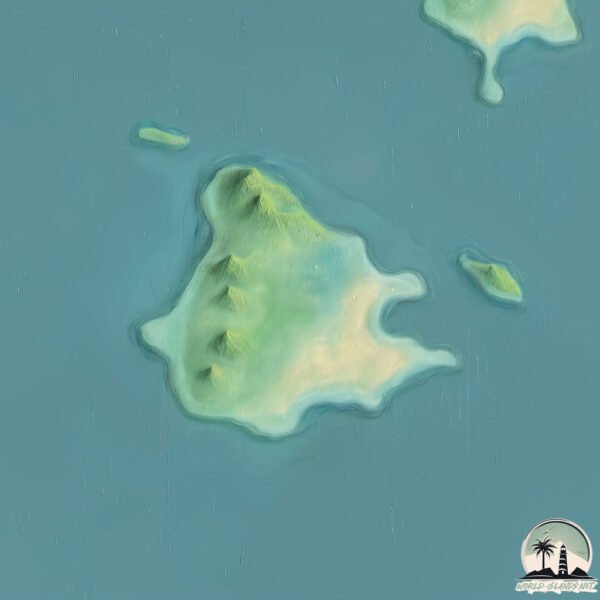
Welcome to Tynemouth Island, a Tropical island in the Coral Sea, part of the majestic Pacific Ocean. This guide offers a comprehensive overview of what makes Tynemouth Island unique – from its geography and climate to its population, infrastructure, and beyond. Dive into the details:
Geography and size of Tynemouth Island
Size: 1.615 km²
Coastline: 6.3 km
Ocean: Pacific Ocean
Sea: Coral Sea
Continent: Oceania
Tynemouth Island is a Small Island spanning 1.6 km² with a coastline of 6.3 km.
Archipel: –
Tectonic Plate: Australia – A major tectonic plate covering Australia, New Zealand, and parts of the Indian and Pacific Oceans, known for its relative stability and occasional seismic activity.
The geographic heart of the island is pinpointed at these coordinates:
Latitude: -21.99575254 / Longitude: 150.13132903
Climate and weather of Tynemouth Island
Climate Zone: Tropical
Climate Details: Tropical Savanna, Wet
Temperature: Hot
Climate Characteristics: Defined by distinct wet and dry seasons with high temperatures year-round. Pronounced rainfall occurs during the wet season, while the dry season is marked by drought.
Topography and nature of Tynemouth Island
Timezone: UTC+10:00
Timezone places: Australia/Sydney
Max. Elevation: 26 m
Mean Elevation: 17 m
Vegetation: Herbaceous Cover
Tree Coverage: 65%
The mean elevation is 17 m. The highest elevation on the island reaches approximately 26 meters above sea level. The island is characterized by Plains: Flat, low-lying lands characterized by a maximum elevation of up to 200 meters. On islands, plains are typically coastal lowlands or central flat areas.
Dominating Vegetation: Herbaceous Cover
Comprising mainly of grasses, herbs, and ferns, these areas are common in prairies, meadows, and savannas, and can vary widely in species composition. Tynemouth Island has a tree cover of 65 %.
Vegetation: 4 vegetation zones – Diverse Island
Four distinct vegetation zones mark these islands as ecologically diverse. They might feature varied landscapes such as forests, beaches, grasslands, and rocky areas. Such diversity reflects the island’s complex ecological interactions and varied habitats, which can support a rich array of wildlife and plant species.
Infrastructure and Travelling to Tynemouth Island
Does the island have a public airport? no.
There is no public and scheduled airport on Tynemouth Island. The nearest airport is Mackay Airport, located 139 km away.
Does the island have a major port? no.
There are no major ports on Tynemouth Island. The closest major port is HAY POINT, approximately 121 km away.
The mean population of Tynemouth Island is 0 per km². Tynemouth Island is Uninhabited. The island belongs to Australia.
Continuing your journey, Quail is the next notable island, situated merely km away.
4 Days in UK - London, Newcastle, Tynemouth, Beamish, Alnwick, Bamburgh, Holy Island
Newcastle upon Tyne commonly known as Newcastle, is a city in Tyne and Wear, North East England, 103 miles (166 km) south ...4 Days in UK - London, Newcastle, Tynemouth, Beamish, Alnwick, Bamburgh, Holy Island
Newcastle upon Tyne commonly known as Newcastle, is a city in Tyne and ...
Newcastle upon Tyne commonly known as Newcastle, is a city in Tyne and Wear, North East England, 103 miles (166 km) south ...
North Shields, Tynemouth, Riley’s Fish Shack and St Mary’s Island
A walk along the Northeast coast and a meal at Riley's Fish Shack ...
A walk along the Northeast coast and a meal at Riley's Fish Shack #rileysfishshack #goodfood #seaview #tynemouth #tyneside ...
Tynemouth Castle #travel #nature #outdoors #castle #northeast #tynemouth #landscape #scenery
The exciting trip to historic tidal St Mary's Island & its Lighthouse Whitley Bay Tyneside England
The exciting trip to historic tidal St Mary's Island & its Lighthouse ...
The exciting trip to historic tidal St Mary's Island & its Lighthouse off Whitley Bay in Tyneside England, filmed on 5.5.24. Dodgy ...
Newcastle coast, Tynemouth, Sunderland, Whitley Bay, St Mary's Island - 4K drone footage
Music credits Music from #Uppbeat (free for Creators!): ...
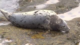
Seal spotting and a walk around St Mary's Lighthouse island (Tyne and Wear, UK)
St Mary's Island, is near Whitley Bay on the North East Coast of ...
St Mary's Island, is near Whitley Bay on the North East Coast of England. The small rocky tidal island is linked to the mainland by a ...
Make The Uk Seaside Your Next Awesome Vacation Destination - Tynemouth
The UK Seaside is AWESOME! Don't listen to the moaners and haters - ...
The UK Seaside is AWESOME! Don't listen to the moaners and haters - Get out there and experience it! TYNEMOUTH typifies the ...
Tynemouth Castle is located on a rocky headland (known as Pen Bal Crag) Cinematic 4K DJI Mini 3.
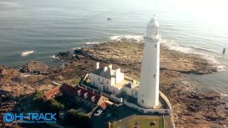
St Marys Island Lighthouse Aerial video Tynemouth
A beautiful morning flying around St Marys Lighthouse. Some amazing ...
A beautiful morning flying around St Marys Lighthouse. Some amazing light and a slight haze in the air.
http://www.Hi-Track.co.uk Aerial ...
Best beach Newcastle - Tynemouth
Seals of St. Mary's Island & Lighthouse Whitley Bay Tyne & Wear
On a recent visit to Whitley Bay Lighthouse i spotted the seals on teh ...
On a recent visit to Whitley Bay Lighthouse i spotted the seals on teh rocks at the back of the lighthouse. St. Mary's Seal Watch is ...
st marys island whitley bay
st marys island with the waves coming over the rocks.
st marys island with the waves coming over the rocks.
Living the Dream: Life on a Tropical Island Paradise
Discover the allure of living in paradise as we delve into the ...
Discover the allure of living in paradise as we delve into the enchanting world of island living. From breathtaking sunsets to ...
St Mary's Lighthouse & Island, Whitley Bay, High Tide
HD video of St Mary's Lighthouse at high tide.
HD video of St Mary's Lighthouse at high tide.
St Marys Island whitley bay
History of St Marys Island Created with MAGIX Video deluxe 17 Plus.
History of St Marys Island Created with MAGIX Video deluxe 17 Plus.
A Walk From Tynemouth To St Marys Island
Created 2012-06-23 20:27:32 +0000.
Created 2012-06-23 20:27:32 +0000.
St Mary's Lighthouse & Island Whitley Bay- St Mary's Lighthouse at low tide
St Mary's Lighthouse at low tide. St Mary's Lighthouse, Whitley Bay- ...
St Mary's Lighthouse at low tide. St Mary's Lighthouse, Whitley Bay- WATCH FULL SCREEN- as high tide gently fades away, the ...
Living on an Island St Mary's Whitley Bay
Living on an Island St Mary's Whitley Bay cut off by the tide for four ...
Living on an Island St Mary's Whitley Bay cut off by the tide for four hours on a midsummer's day on this beautiful island in North ...
St Mary's Island Lighthouse, Whitley Bay
Kiddi Koasta | On Ride | Front Row | Night - Adventure Island POV
All footage was filmed with prior permission of Adventure Island) ...
All footage was filmed with prior permission of Adventure Island) Here's a front row POV of the parks only Zamperla coaster.
The Caribbean Island of Newcastle?! Who knew the North East could feel so tropical?! 🌴 #vanlife
Riley's Fish Bar in Tynemouth was sending me and Tristan right back to ...
Riley's Fish Bar in Tynemouth was sending me and Tristan right back to our trip to Jamaica in December! Just add a bit of sun ...
St Mary's Island Whitley Bay
St Mary's Island, sometimes referred to as bait island is a small ...
St Mary's Island, sometimes referred to as bait island is a small sandstone island near the seaside resort of Whitley Bay Tyne ...
St Mary's Island, Whitley Bay, North Tyneside
A short video with some stills showing the wonderful lighthouse on St. ...
A short video with some stills showing the wonderful lighthouse on St. Mary's Island in Whitley Bay, North East England.
St Mary's Island & Lighthouse near Whitley Bay
St Mary's Island & Lighthouse near Whitley Bay, Tyne & Wear which are ...
St Mary's Island & Lighthouse near Whitley Bay, Tyne & Wear which are accessed at low tide by a causeway. The lighthouse was ...
St Marys Island Whitley Bay -- " The Haunting "
Dare to enter the Island and see for yourself.
Dare to enter the Island and see for yourself.
Australia is classified as Developed region: nonG7: Developed economies outside of the Group of Seven, characterized by high income and advanced economic structures. The level of income is High income: OECD.
News – Latest Updates and Headlines from Tynemouth Island
Stay informed with the most recent news and important headlines from Tynemouth Island. Here’s a roundup of the latest developments.
Loading...
Please note: The data used here has been primarily extracted from satellite readings. Deviations from exact values may occur, particularly regarding the height of elevations and population density. Land area and coastline measurements refer to average values at mean high tide.