Welcome to Udvar, a Temperate island in the Skagerrak, part of the majestic Atlantic Ocean. This guide offers a comprehensive overview of what makes Udvar unique – from its geography and climate to its population, infrastructure, and beyond. Dive into the details:
Geography and size of Udvar
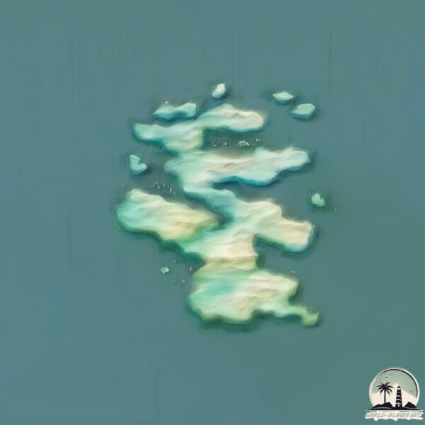
Size: 1.159 km²
Coastline: 11.6 km
Ocean: Atlantic Ocean
Sea: Skagerrak
Continent: Europe
Udvar is a Small Island spanning 1.2 km² with a coastline of 11.6 km.
Archipel: –
Tectonic Plate: Eurasia – One of the world’s largest tectonic plates, the Eurasian Plate covers a significant portion of Europe and Asia. It’s characterized by diverse geological features, including the Ural Mountains, the European Plain, and the Himalayas formed from its collision with the Indian Plate.
The geographic heart of the island is pinpointed at these coordinates:
Latitude: 58.01476629 / Longitude: 7.73074815
Climate and weather of Udvar
Climate Zone: Temperate
Climate Details: Temperate Oceanic Climate
Temperature: Warm Summer
Climate Characteristics: Known for its moderate year-round temperatures with ample rainfall and no dry season. Warm summers are characteristic.
Topography and nature of Udvar
Timezone: UTC+01:00
Timezone places: Europe/Paris
Max. Elevation: -1 m
Mean Elevation: -3 m
Vegetation: Evergreen Needleleaf Forest
Tree Coverage: 71%
The mean elevation is -3 m. Remarkably, this unique island barely emerges above the sea level, showcasing nature’s fascinating interplay with the ocean. The island is characterized by Plains: Flat, low-lying lands characterized by a maximum elevation of up to 200 meters. On islands, plains are typically coastal lowlands or central flat areas.
Dominating Vegetation: Evergreen Needleleaf Forest
Dominated by evergreen coniferous trees such as pines and firs, which retain their needle-like leaves throughout the year. These forests are often found in cooler climates. Udvar has a tree cover of 71 %.
Vegetation: 2 vegetation zones – Low Diversity Island
Islands with two distinct vegetation zones offer slightly more ecological variety. These zones could be due to differences in elevation, moisture, or other environmental factors. While still limited in biodiversity, these islands may offer a contrast between the two zones, such as a coastline with mangroves and an inland area with grassland.
Infrastructure and Travelling to Udvar
Does the island have a public airport? no.
There is no public and scheduled airport on Udvar. The nearest airport is Kristiansand Airport, Kjevik, located 44 km away.
Does the island have a major port? no.
There are no major ports on Udvar. The closest major port is MANDAL, approximately 28 km away.
The mean population of Udvar is 74 per km². Udvar is Gently Populated. The island belongs to Norway.
Continuing your journey, Hidra is the next notable island, situated merely km away.
10 Things I Wish I Knew Before Visiting Budapest
Here's the exact list I share with friends visiting Budapest (my free guide): https://bit.ly/Budapest-Guide-Camden Here's are 10 ...10 Things I Wish I Knew Before Visiting Budapest
Here's the exact list I share with friends visiting Budapest (my free ...
Udvar-Hazy Center Air & Space Museum - Space Shuttle Discovery, Enola Gay, Concorde, SR-71 - 4K
Another video from the Stephen F. Udvar-Hazy Center, part of the ...
Another video from the Stephen F. Udvar-Hazy Center, part of the Smithsonian National Air & Space Museum in Chantilly, VA!
Everything you need to know to visit the Smithsonian Air & Space Museum's Udvar-Hazy Center
Explore the wonders of flight at the Smithsonian Air & Space Museum's ...
Explore the wonders of flight at the Smithsonian Air & Space Museum's Udvar-Hazy Center! ✈️ From historic aircraft to the ...
This is the ultimate luxury hotel experience in Budapest 😍 #travel #hotel #luxuryhotel
TOP 20 THINGS TO DO IN BUDAPEST 4K TRAVEL GUIDE
This video covers the 20 best things to do in Budapest, including ...
This video covers the 20 best things to do in Budapest, including must-see landmarks, thermal baths, nightlife, food, and day trips.
Budapest Areas Explained: Where to Stay and What are the Attractions | Hungary Travel Guide
In this Video we Explain Budapest areas to stay in: Discussing it's ...
In this Video we Explain Budapest areas to stay in: Discussing it's different districts, what is unique about them, what can you find ...
Smithsonian National Air and Space Museum, Steven F. Udvar-Hazy Center. #aviation #history #warbird
A walkaround video in the Steven F. Udvar-Hazy Center, in Virginia, ...
A walkaround video in the Steven F. Udvar-Hazy Center, in Virginia, USA. Where you can see a great variety of aircraft and space ...
Island Hopping in Greece - Nas Beach Sunset in Ikaria - Best Sunsets in Greece
Island Hopping in Greece - Nas Beach Sunset in Ikaria - Ikaria island ...
Island Hopping in Greece - Nas Beach Sunset in Ikaria - Ikaria island is know for its gastronomy and plays a key role as one of the ...
Vanilla Minecraft Animals VS Naturalist
GET IT HERE: ...
TOP 10 BEST Things to do in BUDAPEST | Budapest, Hungary Travel Guide 2024
Welcome to Budapest, Hungary! This vibrant and unique city attracts ...
Welcome to Budapest, Hungary! This vibrant and unique city attracts almost 30 million visitors a year and in this video we want to ...
5 Things You Should NEVER Do in Hungary 🇭🇺 Don't Do This in Budapest
In today's Hungary travel vlog, we discuss 5 Things You Should NEVER ...
In today's Hungary travel vlog, we discuss 5 Things You Should NEVER Do in Hungary and Don't Do This in Budapest. There are ...
Let's go to a plane museum! #aviation #boeing #concorde
This is the biggest scam in Budapest #hungary #traveltips #psa
Part 5 of our Eastern Europe series. Why we won't go back to Budapest, ...
Part 5 of our Eastern Europe series. Why we won't go back to Budapest, Hungary anytime soon. SAVE and share for your next ...
The Most Dangerous Free Cleaning Ever! 💀
If you're struggling, consider therapy with our paid partner Click ...
Flying to Budapest for a spa day - Cheaper than the UK! 💦😳
Flight Simulator xbox series x 👉 Steven F Udvar-Hazy Center Virginia EEUU MORINIUS POR EL MUNDO
FlightSimulator #FlightSimulator2020 ...
FlightSimulator #FlightSimulator2020 #flightsimulator202040thanniversary Flight Simulator xbox series x Steven F Udvar-Hazy ...
F-14 and X-35B, Steven F. Udvar-Hazy Center, United States.
F 14 and X-35B, on display in the Steven F. Udvar-Hazy Center, ...
F 14 and X-35B, on display in the Steven F. Udvar-Hazy Center, Chantilly, VA, United States.
Obuda island in Budapest, Hungary (Big Festivals are here)
Hajógyári was created from the debris carried by the Danube River. It ...
Hajógyári was created from the debris carried by the Danube River. It was originally a reef island made up of two adjoining land ...
2015 January 24 Udvar-Hazy Center Open House 1
At the Udvar-Hazy Center Open House, held on January 24, 2015, more ...
At the Udvar-Hazy Center Open House, held on January 24, 2015, more than 8000 visitors enjoyed a behind-the-scenes look at ...
The most beautiful coffee spot in Budapest. (Párisi Udvar) #shorts
SUBSCRIBE FOR MORE : youtube.com/simonsnopek INSTAGRAM: ...
Enola Gay & The Aircraft of WWII | History Traveler Episode 26
The Smithsonian National Air and Space Museum is one museum in two ...
The Smithsonian National Air and Space Museum is one museum in two locations. In this video, we're going to the Steven F.
Steven F. Udvar-Hazy Center Air And Space Museum
World War II[b] or the Second World War (1 September 1939 – 2 ...
World War II[b] or the Second World War (1 September 1939 – 2 September 1945) was a global conflict between two major ...
CHRISTMAS Giant Outdoor Ornaments
Every tree deserves it's moment!! And these Vickerman finials are IT. ...
Every tree deserves it's moment!! And these Vickerman finials are IT. Please visit my website to keep up on all of the latest ...
National Mall Flyover & Steven F. Udvar-Hazy Center / スミソニアン航空宇宙博物館の別館とレッドロブスター
Welcome to Treasure Island! On today's adventure, we will see the air ...
Welcome to Treasure Island! On today's adventure, we will see the air show at the National Mall. We can see about 60 historical ...
calmprosstock.com E-MAIL TO US, IF YOU WANT TO BUY THIS FOOTAGE ...
Norway is classified as Developed region: nonG7: Developed economies outside of the Group of Seven, characterized by high income and advanced economic structures. The level of income is High income: OECD.
News – Latest Updates and Headlines from Udvar
Stay informed with the most recent news and important headlines from Udvar. Here’s a roundup of the latest developments.
Loading...
Please note: The data used here has been primarily extracted from satellite readings. Deviations from exact values may occur, particularly regarding the height of elevations and population density. Land area and coastline measurements refer to average values at mean high tide.