Ufaon
Welcome to Ufaon, a Tropical island in the Solomon Sea, part of the majestic Pacific Ocean. This guide offers a comprehensive overview of what makes Ufaon unique – from its geography and climate to its population, infrastructure, and beyond. Dive into the details:
- Geography and Size: Explore the island’s size and location.
- Climate and Weather: Weather patterns and temperature.
- Topography and Nature: Uncover the natural wonders of the island.
- Infrastructure and Travelling: Insights on reaching, staying, and making the most of your visit.
- News and Headlines: Latest News.
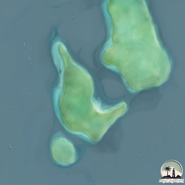
Geography and size of Ufaon
Size: 1.172 km²
Coastline: 6.6 km
Ocean: Pacific Ocean
Sea: Solomon Sea
Continent: Oceania
Ufaon is a Small Island spanning 1.2 km² with a coastline of 6.6 km.
Archipel: Melanesia – A subregion of Oceania in the southwestern Pacific Ocean, including countries like Fiji, Solomon Islands, and Vanuatu, known for their diverse cultures and languages.
Tectonic Plate: Pacific – The world’s largest tectonic plate, covering much of the Pacific Ocean, known for the Pacific Ring of Fire with extensive seismic and volcanic activity.
The geographic heart of the island is pinpointed at these coordinates:
Latitude: -9.06934943 / Longitude: 159.24767614
Climate and weather of Ufaon
Climate Zone: Tropical
Climate Details: Tropical Rainforest Climate
Temperature: Hot
Climate Characteristics: This climate is typified by heavy rainfall throughout the year, high humidity, and consistently high temperatures, leading to lush rainforests and rich biodiversity. Seasonal temperature variations are minimal.
Topography and nature of Ufaon
Timezone: UTC+11:00
Timezone places: Pacific/Guadalcanal
Max. Elevation: 9 m
Mean Elevation: 5 m
Vegetation: Mangrove Forest
Tree Coverage: 88%
The mean elevation is 5 m. The highest elevation on the island reaches approximately 9 meters above sea level. The island is characterized by Plains: Flat, low-lying lands characterized by a maximum elevation of up to 200 meters. On islands, plains are typically coastal lowlands or central flat areas.
Dominating Vegetation: Mangrove Forest
Found in coastal areas and river deltas, these unique wetland ecosystems are adapted to saline conditions and are crucial for coastal protection and biodiversity. Ufaon has a tree cover of 88 %.
Vegetation: 5 vegetation zones – Highly Diverse Island
With five different vegetation zones, these islands offer a rich tapestry of ecosystems. The variety could include dense forests, open meadows, wetlands, coastal zones, and more. This level of diversity supports an intricate web of life, with each zone playing a vital role in the overall ecological health and balance of the island.
Infrastructure and Travelling to Ufaon
Does the island have a public airport? no.
There is no public and scheduled airport on Ufaon. The nearest airport is Yandina Airport, located 4 km away.
Does the island have a major port? no.
There are no major ports on Ufaon. The closest major port is YANDINA, approximately 3 km away.
The mean population of Ufaon is 30 per km². Ufaon is Gently Populated. The island belongs to Solomon Islands.
Continuing your journey, Mbanika is the next notable island, situated merely km away.
Ofu Island 2021


Solomon Islands is classified as Least developed region: Countries that exhibit the lowest indicators of socioeconomic development, with the lowest Human Development Index ratings. The level of income is Lower middle income.
News – Latest Updates and Headlines from Ufaon
Stay informed with the most recent news and important headlines from Ufaon. Here’s a roundup of the latest developments.
Please note: The data used here has been primarily extracted from satellite readings. Deviations from exact values may occur, particularly regarding the height of elevations and population density. Land area and coastline measurements refer to average values at mean high tide.