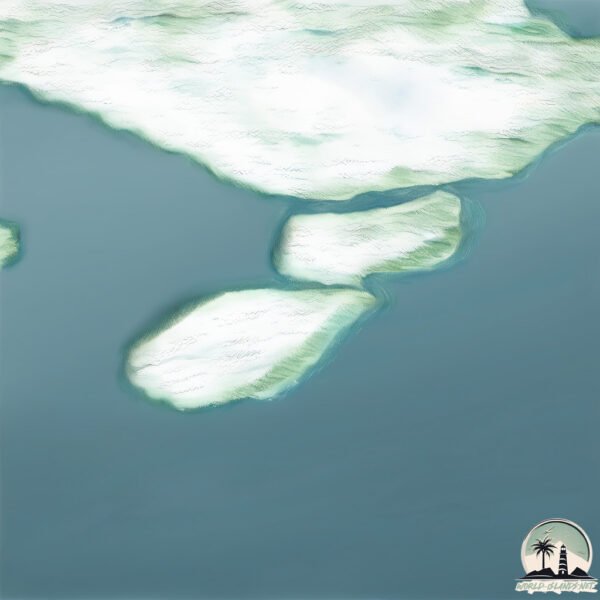
Ulvingen
Welcome to Ulvingen, a Polar island in the The Northwestern Passages, part of the majestic Arctic Ocean. This guide offers a comprehensive overview of what makes Ulvingen unique – from its geography and climate to its population, infrastructure, and beyond. Dive into the details:
- Geography and Size: Explore the island’s size and location.
- Climate and Weather: Weather patterns and temperature.
- Topography and Nature: Uncover the natural wonders of the island.
- Infrastructure and Travelling: Insights on reaching, staying, and making the most of your visit.
- News and Headlines: Latest News.
Geography and size of Ulvingen
Size: 83.3 km²
Coastline: 116.3 km
Ocean: Arctic Ocean
Sea: The Northwestern Passages
Continent: North America
Ulvingen is a Medium Island spanning 83 km² with a coastline of 116 km.
Archipel: Queen Elizabeth Islands – The northernmost part of the Canadian Arctic Archipelago, the Queen Elizabeth Islands are a collection of about 35 major islands. This remote and sparsely populated region is characterized by its polar climate, ice caps, and glaciers. The islands are named in honor of Queen Elizabeth II and are home to diverse Arctic wildlife, including polar bears and seals, and are important for climate research.
Tectonic Plate: Scotia – Situated in the Southern Ocean, surrounding the Scotia Sea, between South America and Antarctica, known for the Scotia Arc and active seismicity.
The geographic heart of the island is pinpointed at these coordinates:
Latitude: 78.34447524 / Longitude: -88.23702381
Climate and weather of Ulvingen
Climate Zone: Polar
Climate Details: Tundra
Temperature: Cold
Climate Characteristics: The tundra climate features long, extremely cold winters and short, cool summers. Vegetation is limited to mosses, lichens, and small shrubs due to the low temperatures and short growing seasons. Biodiversity is low, but some specialized species thrive.
Topography and nature of Ulvingen
Timezone: UTC-06:00
Timezone places: America/Chicago
Max. Elevation: 781 m
Mean Elevation: 182 m
Vegetation: Herbaceous Cover
Tree Coverage: 68%
The mean elevation is 182 m. The highest elevation on the island reaches approximately 781 meters above sea level. The island is characterized by Plateau: Elevated flatlands rising sharply above the surrounding area, with a maximum elevation over 500 meters but a mean elevation less than 300 meters, forming unique highland areas on islands.
Dominating Vegetation: Herbaceous Cover
Comprising mainly of grasses, herbs, and ferns, these areas are common in prairies, meadows, and savannas, and can vary widely in species composition. Ulvingen has a tree cover of 68 %.
Vegetation: 5 vegetation zones – Highly Diverse Island
With five different vegetation zones, these islands offer a rich tapestry of ecosystems. The variety could include dense forests, open meadows, wetlands, coastal zones, and more. This level of diversity supports an intricate web of life, with each zone playing a vital role in the overall ecological health and balance of the island.
Infrastructure and Travelling to Ulvingen
Does the island have a public airport? no.
There is no public and scheduled airport on Ulvingen. The nearest airport is Grise Fiord Airport, located 613 km away.
Does the island have a major port? no.
There are no major ports on Ulvingen. The closest major port is RESOLUTE BAY, approximately 922 km away.
The mean population of Ulvingen is 0 per km². Ulvingen is Uninhabited. The island belongs to Canada.
Continuing your journey, North Kent is the next notable island, situated merely km away.
Airspy/Spyverter - NDB DX - PN 360 - Port Menier/Ile Anticosti, Quebec, Canada


Canada is classified as Developed region: G7: Group of Seven – Major advanced economies, including Canada, France, Germany, Italy, Japan, the United Kingdom, and the United States. The level of income is High income: OECD.
News – Latest Updates and Headlines from Ulvingen
Stay informed with the most recent news and important headlines from Ulvingen. Here’s a roundup of the latest developments.
Please note: The data used here has been primarily extracted from satellite readings. Deviations from exact values may occur, particularly regarding the height of elevations and population density. Land area and coastline measurements refer to average values at mean high tide.