Unimac
Welcome to Unimac, a Continental island in the Bering Sea, part of the majestic Pacific Ocean. This guide offers a comprehensive overview of what makes Unimac unique – from its geography and climate to its population, infrastructure, and beyond. Dive into the details:
- Geography and Size: Explore the island’s size and location.
- Climate and Weather: Weather patterns and temperature.
- Topography and Nature: Uncover the natural wonders of the island.
- Infrastructure and Travelling: Insights on reaching, staying, and making the most of your visit.
- News and Headlines: Latest News.
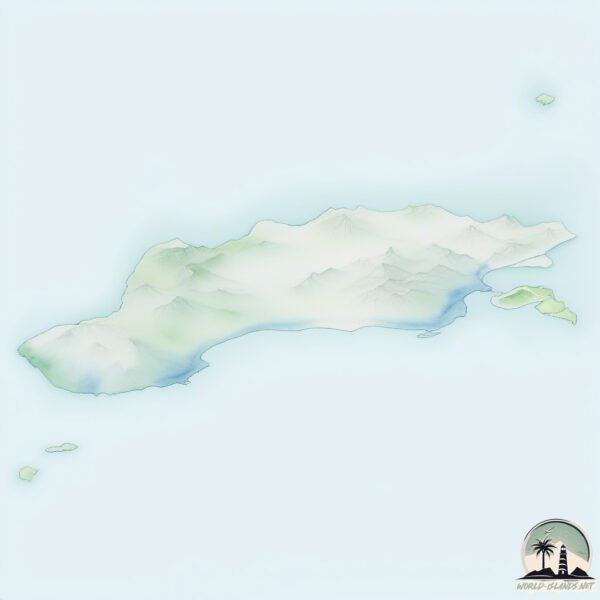
Geography and size of Unimac
Size: 4047 km²
Coastline: 745 km
Ocean: Pacific Ocean
Sea: Bering Sea
Continent: North America
Unimac is a Very Large Island spanning 4047 km² with a coastline of 745 km.
Archipel: Aleutian Islands – A chain of islands stretching from Alaska to Russia, known for their rugged beauty, abundant wildlife, and volcanic activity.
Tectonic Plate: North America – Covers North America and parts of the Atlantic and Arctic Oceans, characterized by diverse geological features and varying levels of seismic activity.
The geographic heart of the island is pinpointed at these coordinates:
Latitude: 54.73709964 / Longitude: -164.09652315
Climate and weather of Unimac
Climate Zone: Continental
Climate Details: Subarctic Climate
Temperature: Cold Summer
Climate Characteristics: Characterized by long, extremely cold winters and short, cool summers, often found in northern latitudes of North America and Eurasia.
Topography and nature of Unimac
Timezone: UTC-09:00
Timezone places: America/Anchorage
Max. Elevation: 2869 m Shishaldin Volcano
Mean Elevation: 279 m
Vegetation: Wetland
Tree Coverage: 13%
The mean elevation is 279 m. Dominating the island’s landscape, the majestic “Shishaldin Volcano” rises as the highest peak, soaring to impressive heights. The island is characterized by Plateau: Elevated flatlands rising sharply above the surrounding area, with a maximum elevation over 500 meters but a mean elevation less than 300 meters, forming unique highland areas on islands.
Dominating Vegetation: Wetland
These areas are saturated with water, either permanently or seasonally, and support aquatic plants. Wetlands are important for biodiversity and water filtration. Unimac has a tree cover of 13 %.
Vegetation: 15 vegetation zones – Exceptionally Diverse Island
Islands with more than ten vegetation zones are among the most ecologically rich and varied in the world. These islands are akin to miniature continents, boasting an incredible array of ecosystems. The sheer range of habitats, from high peaks to deep valleys, rainforests to deserts, creates a mosaic of life that is unparalleled. They are crucial for conservation and ecological studies.
Infrastructure and Travelling to Unimac
Does the island have a public airport? no.
There is no public and scheduled airport on Unimac. The nearest airport is Akutan Airport, located 86 km away.
Does the island have a major port? no.
There are no major ports on Unimac. The closest major port is SANAK, approximately 33 km away.
The mean population of Unimac is 0 per km². Unimac is Uninhabited. The island belongs to United States of America.
The name of the island resonates across different cultures and languages. Here is how it is known around the world: Arabic: جزيرة أونيماك; German: Unimak Island; Spanish: Isla Unimak; French: Île Unimak; Portuguese: Ilha Unimak; Russian: Унимак; Chinese: 烏尼馬克島
Continuing your journey, Tigalda is the next notable island, situated merely km away.
The Giant Bears of Unimak trailer


United States of America is classified as Developed region: G7: Group of Seven – Major advanced economies, including Canada, France, Germany, Italy, Japan, the United Kingdom, and the United States. The level of income is High income: OECD.
News – Latest Updates and Headlines from Unimac
Stay informed with the most recent news and important headlines from Unimac. Here’s a roundup of the latest developments.
Social Media Posts about Unimac
Please note: The data used here has been primarily extracted from satellite readings. Deviations from exact values may occur, particularly regarding the height of elevations and population density. Land area and coastline measurements refer to average values at mean high tide.