Uri
Welcome to Uri, a Tropical island in the Coral Sea, part of the majestic Pacific Ocean. This guide offers a comprehensive overview of what makes Uri unique – from its geography and climate to its population, infrastructure, and beyond. Dive into the details:
- Geography and Size: Explore the island’s size and location.
- Climate and Weather: Weather patterns and temperature.
- Topography and Nature: Uncover the natural wonders of the island.
- Infrastructure and Travelling: Insights on reaching, staying, and making the most of your visit.
- News and Headlines: Latest News.
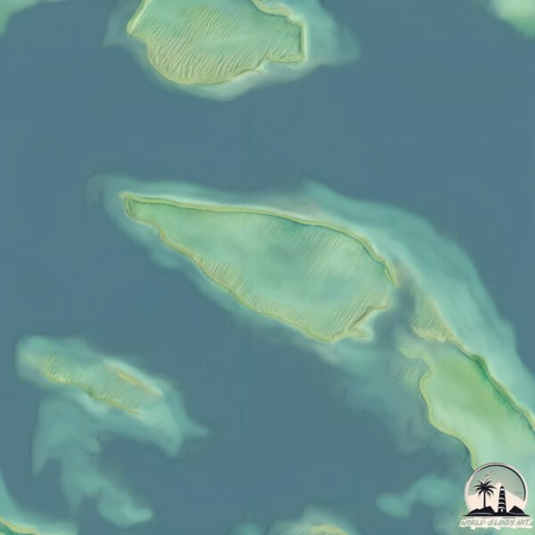
Geography and size of Uri
Size: 1.594 km²
Coastline: 5.4 km
Ocean: Pacific Ocean
Sea: Coral Sea
Continent: Oceania
Uri is a Small Island spanning 1.6 km² with a coastline of 5.4 km.
Archipel: Melanesia – A subregion of Oceania in the southwestern Pacific Ocean, including countries like Fiji, Solomon Islands, and Vanuatu, known for their diverse cultures and languages.
Tectonic Plate: Somalia – A large tectonic plate covering the Horn of Africa and parts of the Indian Ocean, known for the East African Rift where it’s splitting away from the African Plate.
The geographic heart of the island is pinpointed at these coordinates:
Latitude: -16.08958567 / Longitude: 167.45695656
Climate and weather of Uri
Climate Zone: Tropical
Climate Details: Tropical Rainforest Climate
Temperature: Hot
Climate Characteristics: This climate is typified by heavy rainfall throughout the year, high humidity, and consistently high temperatures, leading to lush rainforests and rich biodiversity. Seasonal temperature variations are minimal.
Topography and nature of Uri
Timezone: UTC+11:00
Timezone places: Pacific/Guadalcanal
Max. Elevation: 1 m
Mean Elevation: -10 m
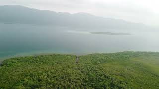
Vegetation: Evergreen Broadleaf Forest
Tree Coverage: 61%
The mean elevation is -10 m. The highest elevation on the island reaches approximately 1 meters above sea level. The island is characterized by Plains: Flat, low-lying lands characterized by a maximum elevation of up to 200 meters. On islands, plains are typically coastal lowlands or central flat areas.
Dominating Vegetation: Evergreen Broadleaf Forest
Characterized by dense, lush canopies of broadleaf trees that retain their leaves year-round. These forests are typically found in tropical and subtropical regions and are known for their high biodiversity. Uri has a tree cover of 61 %.
Vegetation: 3 vegetation zones – Moderately Diverse Island
These islands start to show a broader range of ecological niches. With three vegetation zones, they may offer a mix of ecosystems like coastal areas, inland woods, and perhaps a distinct wetland or dry area. This diversity supports a wider range of flora and fauna, making these islands more ecologically complex than those with minimal diversity.
Infrastructure and Travelling to Uri
Does the island have a public airport? no.
There is no public and scheduled airport on Uri. The nearest airport is Norsup Airport, located 5 km away.
Does the island have a major port? no.
There are no major ports on Uri. The closest major port is LUGANVILLE, approximately 70 km away.
The mean population of Uri is 14 per km². Uri is Gently Populated. The island belongs to Vanuatu.
Continuing your journey, Malakula is the next notable island, situated merely km away.
Malekula, Uri Island


Vanuatu is classified as Least developed region: Countries that exhibit the lowest indicators of socioeconomic development, with the lowest Human Development Index ratings. The level of income is Lower middle income.
News – Latest Updates and Headlines from Uri
Stay informed with the most recent news and important headlines from Uri. Here’s a roundup of the latest developments.
Please note: The data used here has been primarily extracted from satellite readings. Deviations from exact values may occur, particularly regarding the height of elevations and population density. Land area and coastline measurements refer to average values at mean high tide.