Welcome to Vardoya, a Temperate island in the Barentsz Sea, part of the majestic Arctic Ocean. This guide offers a comprehensive overview of what makes Vardoya unique – from its geography and climate to its population, infrastructure, and beyond. Dive into the details:
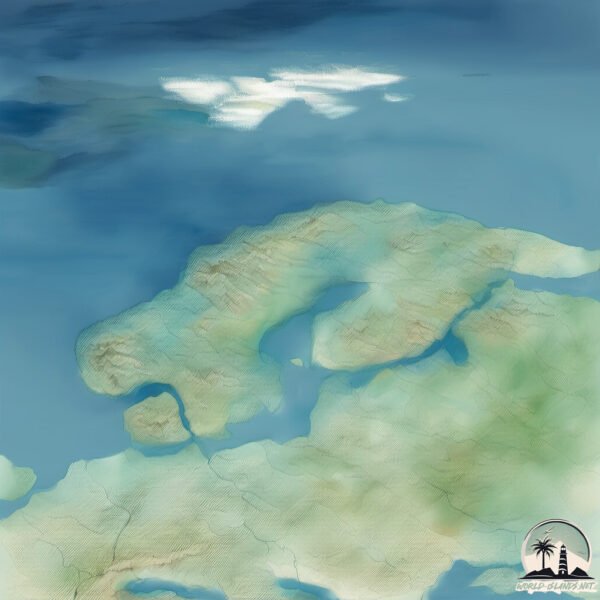
Geography and size of Vardoya
Size: 3.971 km²
Coastline: 17.4 km
Ocean: Arctic Ocean
Sea: Barentsz Sea
Continent: Europe
Vardoya is a Small Island spanning 4 km² with a coastline of 17.4 km.
Archipel: –
Tectonic Plate: Eurasia – One of the world’s largest tectonic plates, the Eurasian Plate covers a significant portion of Europe and Asia. It’s characterized by diverse geological features, including the Ural Mountains, the European Plain, and the Himalayas formed from its collision with the Indian Plate.
The geographic heart of the island is pinpointed at these coordinates:
Latitude: 68.60927724 / Longitude: 27.77948112
Climate and weather of Vardoya
Climate Zone: Temperate
Climate Details: Temperate Oceanic Climate
Temperature: Warm Summer
Climate Characteristics: Known for its moderate year-round temperatures with ample rainfall and no dry season. Warm summers are characteristic.
Topography and nature of Vardoya
Timezone: UTC+01:00
Timezone places: Europe/Paris
Max. Elevation: 50 m
Mean Elevation: 30 m
Vegetation: Evergreen Needleleaf Forest
Tree Coverage: 93%
The mean elevation is 30 m. The highest elevation on the island reaches approximately 50 meters above sea level. The island is characterized by Plains: Flat, low-lying lands characterized by a maximum elevation of up to 200 meters. On islands, plains are typically coastal lowlands or central flat areas.
Dominating Vegetation: Evergreen Needleleaf Forest
Dominated by evergreen coniferous trees such as pines and firs, which retain their needle-like leaves throughout the year. These forests are often found in cooler climates. Vardoya has a tree cover of 93 %.
Vegetation: 4 vegetation zones – Diverse Island
Four distinct vegetation zones mark these islands as ecologically diverse. They might feature varied landscapes such as forests, beaches, grasslands, and rocky areas. Such diversity reflects the island’s complex ecological interactions and varied habitats, which can support a rich array of wildlife and plant species.
Infrastructure and Travelling to Vardoya
Does the island have a public airport? no.
There is no public and scheduled airport on Vardoya. The nearest airport is Vardø Airport, Svartnes, located 4 km away.
Does the island have a major port? yes.
Vardoya is home to a major port. The following ports are situated on the island: VARDO.
The mean population of Vardoya is 8 per km². Vardoya is Gently Populated. The island belongs to Norway.
Continuing your journey, Tromoy is the next notable island, situated merely km away.
A Norwegian Gem: Horn Island - Hornøya/Vardø
Quite spectacular. The northernmost nature reserve in Europe. An isolated alluring island where birds create all sorts of drama ...A Norwegian Gem: Horn Island - Hornøya/Vardø
Quite spectacular. The northernmost nature reserve in Europe. An ...
Quite spectacular. The northernmost nature reserve in Europe. An isolated alluring island where birds create all sorts of drama ...
Amazing arctic birds - The island of Hornøya in Norway
A beautiful trip to Hornøya bird mountain.
A beautiful trip to Hornøya bird mountain.
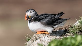
Puffins paradise at Hornøya in Vardø, Northern Norway
puffins #birds #birdingtrip Less than 3 hours driving from our ...
puffins #birds #birdingtrip Less than 3 hours driving from our cottages we visit the island of Hornøya, the easternmost point of ...
Hornoya Bird Island, Vardø, Norway
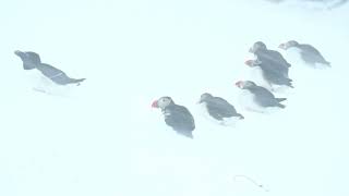
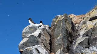
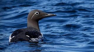
Guillemots, Black Guillemots, Brünnich's Guillemots, Puffins, ...
Guillemots, Black Guillemots, Brünnich's Guillemots, Puffins, Razorbill, Kittiwakes, Fulmars, Shags etc.
Crazy Bird Action on Remote Island, Arctic Norway
Watch your head. Shit happens. Birds everywhere on this remote bird ...
Watch your head. Shit happens. Birds everywhere on this remote bird location in the Norwegian arctic. Atlantic puffins, common ...
Hornoya Island, Norway
We visited Hornoya Island off of Vardo, Norway during Sunrise ...
We visited Hornoya Island off of Vardo, Norway during Sunrise Birding's 2018 Norway Birding Tour. The island has thousands of ...
Drakkar Leviathan - Insel Vardø in Norwegen
drakkar #norwegen #vikings Auf der kleinen Insel Vardø gibt es ...
drakkar #norwegen #vikings Auf der kleinen Insel Vardø gibt es allerhand zu entdecken. Die Einwohner haben die Skulptur zu ...
Visit Vardo movie © 2017 Biotope
Ostrov Hornøya, Norsko - Hornøya island, Norway
I Would've Missed This Arctic Fortress Without a Viewer’s Tip – Vardøhus, Norway #travel #mapguide
A viewer tipped me off—and Google Earth took me to Vardøhus Fortress, ...
A viewer tipped me off—and Google Earth took me to Vardøhus Fortress, the northernmost fortress in Europe, quietly standing ...
Puffins in a snowstorm on the island of Hornoya in Norway in March 2022. 4K HDR
Lunnit lumella ja oikeassa lumimyrskyssä Hornoyan saarella Norjassa. ...
Lunnit lumella ja oikeassa lumimyrskyssä Hornoyan saarella Norjassa. Kuvattu Sony A1 + FE 200-600 (original 8K)
Hornoya Aerial Drone 4K / Norway
Hornøya is a small, uninhabited island in Vardø Municipality in ...
Hornøya is a small, uninhabited island in Vardø Municipality in Finnmark county, Norway. It lies in the Barents Sea, just east of the ...
Hidden Paradises: Discovering a Secret Village
Join us as we unveil the hidden village of Vardø, Norway, a ...
Join us as we unveil the hidden village of Vardø, Norway, a breathtaking destination rich in culture and history. Explore this ...
Hornøya and Vardø June Week 24 2017 Tormod Amundsen Vlog © Biotope
This weeks videoblog: We did three trips to Hornøya this week. Biotope ...
This weeks videoblog: We did three trips to Hornøya this week. Biotope do not do your regular day to day guiding, but on special ...
Вардо норвегия крайний север остров
NORVEGIA NORD ISLAND VARDO,,TUNNEL 3KM,,,-88M.
NORVEGIA NORD ISLAND VARDO,,TUNNEL 3KM,,,-88M.
Op vakantie naar Vardo in Noorwegen
We zijn op vakantie naar Vardo van 3 t/m 10 mei, op bezoek bij Leo. ...
We zijn op vakantie naar Vardo van 3 t/m 10 mei, op bezoek bij Leo. Vardo is een eiland wat in het noord-oosten ligt van ...
The Enigmatic Vardo Witch Trials and Fortress: Norway's Chilling Past
This captivating script invites viewers to explore Norway's Vardo ...
This captivating script invites viewers to explore Norway's Vardo Island, revealing its haunting history with the witch trials and the ...
Bird island Hornøya in the far North East of Norway - Puffins
Puffin Brünnich's Guillemot Common Guillemot Razorbill Black Guillemot ...
Puffin Brünnich's Guillemot Common Guillemot Razorbill Black Guillemot Black-legged Kittiwake Glaucous Gull Herring Gull ...
Broedvogel eiland Hornoya, Varanager - Noorwegen
Tijdens onze fantastische vogelreis naar Finland en Varanger in 2022 ...
Tijdens onze fantastische vogelreis naar Finland en Varanger in 2022 zijn we natuurlijk op het broedvogeleiland Hornoya in ...
A trip to Hornøya in Norway
An unforgettable trip to the uninhabited island of Hornøya, occupied ...
An unforgettable trip to the uninhabited island of Hornøya, occupied only by thousands of seabirds,
Birding Finland and Varanger 5/9 Hornøya island
Birding Hornøya island in May 2023.
Birding Hornøya island in May 2023.
A night alone on the bird island - tips for bird photography
I spent 24 hours on the bird island of Hornoya in the north-east of ...
I spent 24 hours on the bird island of Hornoya in the north-east of Norway. With several 10000 seabirds (puffins, razorbills, ...
Hornøya
Hornøya is a bird watcher's paradise. This arctic island is situated ...
Hornøya is a bird watcher's paradise. This arctic island is situated near vardo norway. I've never been so close to so many birds..
Photographing Puffins on snow in Northern Norway - a guide
There is a unique moment in time each year in a small seabird nesting ...
There is a unique moment in time each year in a small seabird nesting island in the Barents Sea when the photogenic Puffins start ...
The Bird Island Hornøya In Norway 1Of2
Perched off mainland Norway's easternmost point, Hornøya is the jewel ...
Perched off mainland Norway's easternmost point, Hornøya is the jewel in Varanger's natural crown. A wild island inhabited by ...
Norway is classified as Developed region: nonG7: Developed economies outside of the Group of Seven, characterized by high income and advanced economic structures. The level of income is High income: OECD.
News – Latest Updates and Headlines from Vardoya
Stay informed with the most recent news and important headlines from Vardoya. Here’s a roundup of the latest developments.
Loading...
Please note: The data used here has been primarily extracted from satellite readings. Deviations from exact values may occur, particularly regarding the height of elevations and population density. Land area and coastline measurements refer to average values at mean high tide.