Welcome to Vlieland, a Temperate island in the North Sea, part of the majestic Atlantic Ocean. This guide offers a comprehensive overview of what makes Vlieland unique – from its geography and climate to its population, infrastructure, and beyond. Dive into the details:
Geography and size of Vlieland
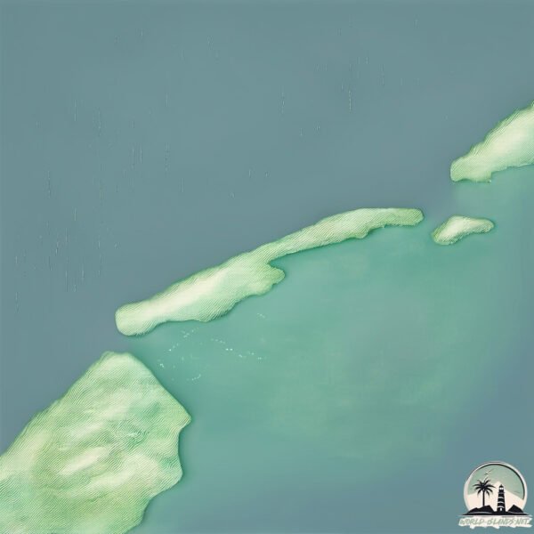
Size: 33.7 km²
Coastline: 69.2 km
Ocean: Atlantic Ocean
Sea: North Sea
Continent: Europe
Vlieland is a Medium Island spanning 34 km² with a coastline of 69 km.
Archipel: Frisian Islands – A chain of islands in the North Sea, off the coasts of the Netherlands, Germany, and Denmark, known for their distinctive culture and natural beauty.
Tectonic Plate: Eurasia – One of the world’s largest tectonic plates, the Eurasian Plate covers a significant portion of Europe and Asia. It’s characterized by diverse geological features, including the Ural Mountains, the European Plain, and the Himalayas formed from its collision with the Indian Plate.
The geographic heart of the island is pinpointed at these coordinates:
Latitude: 53.26086713 / Longitude: 4.96878704
Climate and weather of Vlieland
Climate Zone: Temperate
Climate Details: Temperate Oceanic Climate
Temperature: Warm Summer
Climate Characteristics: Known for its moderate year-round temperatures with ample rainfall and no dry season. Warm summers are characteristic.
Topography and nature of Vlieland
Timezone: UTC+01:00
Timezone places: Europe/Paris
Max. Elevation: 19 m
Mean Elevation: 2 m
Vegetation: Agricultural Mosaic
Tree Coverage: 63%
The mean elevation is 2 m. The highest elevation on the island reaches approximately 19 meters above sea level. The island is characterized by Plains: Flat, low-lying lands characterized by a maximum elevation of up to 200 meters. On islands, plains are typically coastal lowlands or central flat areas.
Dominating Vegetation: Agricultural Mosaic
A mix of cropland and natural vegetation, often seen in rural landscapes where agricultural fields are interspersed with patches of natural habitats. Vlieland has a tree cover of 63 %.
Vegetation: 12 vegetation zones – Exceptionally Diverse Island
Islands with more than ten vegetation zones are among the most ecologically rich and varied in the world. These islands are akin to miniature continents, boasting an incredible array of ecosystems. The sheer range of habitats, from high peaks to deep valleys, rainforests to deserts, creates a mosaic of life that is unparalleled. They are crucial for conservation and ecological studies.
Infrastructure and Travelling to Vlieland
Does the island have a public airport? no.
There is no public and scheduled airport on Vlieland. The nearest airport is Amsterdam Airport Schiphol, located 101 km away.
Does the island have a major port? no.
There are no major ports on Vlieland. The closest major port is DEN HELDER, approximately 28 km away.
The mean population of Vlieland is 24 per km². Vlieland is Gently Populated. The island belongs to Netherlands.
Continuing your journey, Texel is the next notable island, situated merely km away.
vlieland is the Best island
vlieland is the Best island
Vlieland - A Complete Impression in 4 minutes
Vlieland is such a wonderful place to be in the Netherlands. With its ...
Vlieland is such a wonderful place to be in the Netherlands. With its pure nature, the rough North sea and unique animals, ...
First time on an Island in the Netherlands! --- VLIELAND #Vlog #Netherlands
We spent two days on the Island Vlieland in the Northern part of the ...
We spent two days on the Island Vlieland in the Northern part of the Netherlands. There are about 5 Islands in total which are part ...
📍Vlieland, The Netherlands 🇳🇱 🏝️ #vlieland #thenetherlands #island #beach #drone
Vlieland — a tiny Dutch island without cars and bikes take the lead . ...
Vlieland — a tiny Dutch island without cars and bikes take the lead . Surrounded by dunes, sea and endless skies, it's the ...
Great North Sea | Vlieland | Dutch 🇳🇱 | Travel vLog | 2015
Beach View Time-lapse Vlieland island in the northern Netherlands. ...
Vlieland Extended Movie - 100% REAL Nature Sounds!
For all the nature lovers out there, we made a special video with 100% ...
For all the nature lovers out there, we made a special video with 100% real nature sounds of Vlieland. Enjoy the sound of the sea ...
Visiting Dutch island VLIELAND & documenting it all in my sketchbook 📚👩🎨
Welcome on my channel! In this video, I visit the Dutch Wadden Island ...
Welcome on my channel! In this video, I visit the Dutch Wadden Island Vlieland. I bring my sketchbook and paints with me to ...
CASTAWAY ISLAND/ VLIELAND THE NETHERLANDS
Island #Mavicpro #wanderlust I am taking you on my castaway adventure ...
Island #Mavicpro #wanderlust I am taking you on my castaway adventure in one of the small islands in the Netherlands.
Vlieland 4K
Vlieland Tour gefilmd in 4K Vlieland is vanuit het westen gerekend het ...
Vlieland Tour gefilmd in 4K Vlieland is vanuit het westen gerekend het tweede bewoonde Nederlandse Waddeneiland. Het ligt in ...
This is your sign to visit Vlieland - Hotel het Eiland
Tijd voor jezelf. Tijd voor Vlieland. Ontspan, ontdek, adem uit. Wij ...
Tijd voor jezelf. Tijd voor Vlieland. Ontspan, ontdek, adem uit. Wij zijn jouw oase van rust, midden in de natuur, aan de rand van ...
🌊 Discovering Tranquility at Vlieland Beach: A Hidden Gem in the Netherlands 🇳🇱
Vlieland is one of the Dutch Wadden Islands and has a beautiful beach ...
Vlieland is one of the Dutch Wadden Islands and has a beautiful beach on its northern side. The North Sea beach is one of the ...
Standing on top of the world at the island of Vlieland #vlieland #wadden
A short pan of the dunes between the village and the "Posthuis" ---- ...
A short pan of the dunes between the village and the "Posthuis" ---- buy me a coffee: ...
THE ISLAND LIFE IN VLIELAND // VISUAL FILM
A bit of a different video from me. No upbeat song, just a very ...
A bit of a different video from me. No upbeat song, just a very calming and relaxed video. I also decided to experiment with ...
Vlieland- Vliehors
Het Wadden eiland Vlieland. Langs het wad en over het Noordzeestrand ...
Het Wadden eiland Vlieland. Langs het wad en over het Noordzeestrand naar het einde van de Vliehors en terug op een grijze ...
Vlieland, The Wadden Islands, the Netherlands
Lekker even weg, een paar dagen uitwaaien op Vlieland. We waren al ...
Lekker even weg, een paar dagen uitwaaien op Vlieland. We waren al snel in de ban van de serene rust van het eiland.
🛳️ Saying Goodbye to Vlieland: A Bittersweet Journey Back to the Mainland 🇳🇱
As our time on Vlieland comes to an end, we board the ferry that will ...
As our time on Vlieland comes to an end, we board the ferry that will take us back to the mainland. It's a bittersweet moment, as we ...
Het wadden eiland Vlieland heeft een prachtig strand.
Vlieland heeft niet alleen een prachtig strand maar ook een leuk dorp, ...
Vlieland heeft niet alleen een prachtig strand maar ook een leuk dorp, een mooi bos, leuke fietsroutes en naast de Noordzee ook ...
'Vlieland' Impression for Landal Greenparks
This impression-video of the island 'Vlieland' in the Netherlands is ...
This impression-video of the island 'Vlieland' in the Netherlands is produced by Paul Ekelmans | ekelmans.tv carried out for Tin ...
The dutch island :Vlieland #netherlands #summer #nederland #island #traveling
Vlieland is one of the West Frisian Islands, lying in the Wadden Sea. ...
Vlieland is one of the West Frisian Islands, lying in the Wadden Sea. Vlieland can be reached by ferry from the Frisian town of ...
20180822 ~ Beach & Dunes of Wadden Sea Island Vlieland
① memo 20180822 ~ Beach & Dunes of Wadden Sea Island Vlieland ~ Lazy ...
① memo 20180822 ~ Beach & Dunes of Wadden Sea Island Vlieland ~ Lazy saturday afternoon around the beach last month ...
🦭Seals of Vlieland: Captivating Marine Mammals in a Natural Paradise 🇳🇱
Vlieland, one of the Dutch Wadden Islands located in the North Sea, is ...
Vlieland, one of the Dutch Wadden Islands located in the North Sea, is a fascinating destination known for its stunning natural ...
A Quick Tour Around Dutch VLIELAND (Friesland) | Islands of the Netherlands | car free Oost-Vlieland
Thank you for watching! Don't forget to subscribe and like, it really ...
Thank you for watching! Don't forget to subscribe and like, it really makes a difference. #Vlieland #dutchIslands ...
Vlieland - Hiking the Wadden Sea Islands
Een trekkers film van het Waddeneiland Vlieland. Met de rugzak het ...
Een trekkers film van het Waddeneiland Vlieland. Met de rugzak het eiland rond. A trekking film from the Wadden Sea Island of ...
Island Hopping across the Wadden Sea when Cyling to Oost-Vlieland - Part (1/2) (10/08/2025)
On August 10th 2025, after 2 nights in Den Helder just 2 days after ...
On August 10th 2025, after 2 nights in Den Helder just 2 days after Amsterdam previously, I decided to hop on board the ferry from ...
Are There Campsites On Vlieland? - Exploring The Benelux
Are There Campsites On Vlieland? If you're looking for a unique ...
Are There Campsites On Vlieland? If you're looking for a unique camping experience, Vlieland Island in the Benelux region is a ...
Netherlands is classified as Developed region: nonG7: Developed economies outside of the Group of Seven, characterized by high income and advanced economic structures. The level of income is High income: OECD.
News – Latest Updates and Headlines from Vlieland
Stay informed with the most recent news and important headlines from Vlieland. Here’s a roundup of the latest developments.
Loading...
Please note: The data used here has been primarily extracted from satellite readings. Deviations from exact values may occur, particularly regarding the height of elevations and population density. Land area and coastline measurements refer to average values at mean high tide.