Watota
Welcome to Watota, a Tropical island in the Solomon Sea, part of the majestic Pacific Ocean. This guide offers a comprehensive overview of what makes Watota unique – from its geography and climate to its population, infrastructure, and beyond. Dive into the details:
- Geography and Size: Explore the island’s size and location.
- Climate and Weather: Weather patterns and temperature.
- Topography and Nature: Uncover the natural wonders of the island.
- Infrastructure and Travelling: Insights on reaching, staying, and making the most of your visit.
- News and Headlines: Latest News.
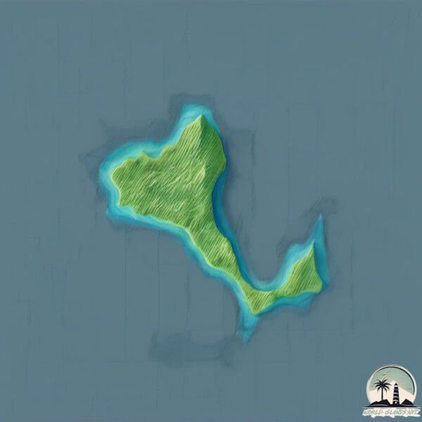
Geography and size of Watota
Size: 2.666 km²
Coastline: 11.9 km
Ocean: Pacific Ocean
Sea: Solomon Sea
Continent: Oceania
Watota is a Small Island spanning 2.7 km² with a coastline of 11.9 km.
Archipel: Melanesia – A subregion of Oceania in the southwestern Pacific Ocean, including countries like Fiji, Solomon Islands, and Vanuatu, known for their diverse cultures and languages.
Tectonic Plate: Woodlark – Situated in the eastern part of Papua New Guinea, the Woodlark Plate is a small tectonic plate primarily consisting of oceanic crust and undergoing active rifting, contributing to the complex geology of the region.
The geographic heart of the island is pinpointed at these coordinates:
Latitude: -9.30087265 / Longitude: 150.7053318
Climate and weather of Watota
Climate Zone: Tropical
Climate Details: Tropical Rainforest Climate
Temperature: Hot
Climate Characteristics: This climate is typified by heavy rainfall throughout the year, high humidity, and consistently high temperatures, leading to lush rainforests and rich biodiversity. Seasonal temperature variations are minimal.
Topography and nature of Watota
Timezone: UTC+10:00
Timezone places: Australia/Sydney
Max. Elevation: 84 m
Mean Elevation: 47 m
Vegetation: Evergreen Broadleaf Forest
Tree Coverage: 84%
The mean elevation is 47 m. The highest elevation on the island reaches approximately 84 meters above sea level. The island is characterized by Plains: Flat, low-lying lands characterized by a maximum elevation of up to 200 meters. On islands, plains are typically coastal lowlands or central flat areas.
Dominating Vegetation: Evergreen Broadleaf Forest
Characterized by dense, lush canopies of broadleaf trees that retain their leaves year-round. These forests are typically found in tropical and subtropical regions and are known for their high biodiversity. Watota has a tree cover of 84 %.
Vegetation: 4 vegetation zones – Diverse Island
Four distinct vegetation zones mark these islands as ecologically diverse. They might feature varied landscapes such as forests, beaches, grasslands, and rocky areas. Such diversity reflects the island’s complex ecological interactions and varied habitats, which can support a rich array of wildlife and plant species.
Infrastructure and Travelling to Watota
Does the island have a public airport? no.
There is no public and scheduled airport on Watota. The nearest airport is Losuia Airport, located 96 km away.
Does the island have a major port? no.
There are no major ports on Watota. The closest major port is ALOTOA, approximately 115 km away.
The mean population of Watota is 30 per km². Watota is Gently Populated. The island belongs to Papua New Guinea.
Continuing your journey, Fergusson is the next notable island, situated merely km away.
We Will Go - Watoto Children's Choir (Official Music Video)


Papua New Guinea is classified as Developing region: Regions characterized by lower income levels, with economies in the process of industrialization and modernization. The level of income is Lower middle income.
News – Latest Updates and Headlines from Watota
Stay informed with the most recent news and important headlines from Watota. Here’s a roundup of the latest developments.
Please note: The data used here has been primarily extracted from satellite readings. Deviations from exact values may occur, particularly regarding the height of elevations and population density. Land area and coastline measurements refer to average values at mean high tide.